METAR & TAF KSUX
Current METAR
Observed 20:52Z
KSUX 272052Z 08005KT 9SM CLR 36/21 A2980 RMK AO2 SLP078 T03560206 55002 $
- Wind
- 080° @ 5 kt
- Visibility
- 9 SM
- Temp / Dew
- 36°C / 21°C
- Altimeter
- 29.80 inHg
- Clouds
- CLR
- Density alt
- 4,031 ft
- Ceiling
- Unlimited
- Rules
- VFR
Airport info & contacts
Manager on record, flight service, ARTCC, attendance schedule and pattern altitude — published by the FAA and refreshed every 28 days.
Location
- From city
- 6 NM S
- VFR sectional
- OMAHA
- ARTCC
- ZMP · MINNEAPOLIS
- NOTAM facility
- SUX (NOTAM-D)
Airport manager
- Name
- MR. ALVIN LORENZO
- Phone
- 720-365-6312
- Address
- 2403 AVIATION BLVD., SIOUX CITY IA 51111
Flight service · Hours
- FSS FOD
- FORT DODGE1-800-WX-BRIEF
- Attendance
- MON-SUN · 0400-0000
Frequencies
Tap any row to copy the frequency to your clipboard.
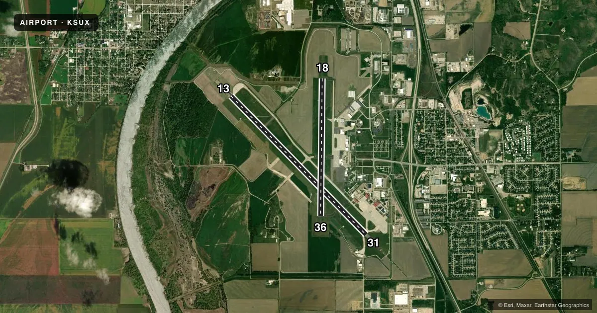
Runways & pattern
Full pagePattern entry · RWY 13
LEFT TRAFFIC| Runway | Heading (°M) | Length | Surface | Traffic |
|---|---|---|---|---|
| 13/31Favored | 133° / 313° | 9,002 ft | CONC | Standard L |
| 18/36 | 178° / 358° | 6,401 ft | ASPH | Standard L |
Runway end performance
| End | TORA | TODA | ASDA | LDA | VGSI | Approach lights | Obstruction |
|---|---|---|---|---|---|---|---|
| 13 | 9,002' | 9,002' | 9,002' | 9,002' | VASI 4-box left(3°) | MALS | 72', tree, 3100' from thr, 475' R of cntrln, slope 40 |
| 31 | 9,002' | 9,002' | 9,002' | 9,002' | VASI 4-box left(3°) | MALSR | — |
| 18 | 6,400' | 6,400' | 6,400' | 6,400' | PAPI 4-box right(3°) | — | 47', trees, 1160' from thr, 350' R of cntrln, slope 20 |
| 36 | 6,400' | 6,400' | 6,400' | 6,400' | PAPI 4-box left(3°) | — | 16', pole, 900' from thr, 0' R of cntrln, slope 43 |
Declared distances in feet. TORA = takeoff run available, TODA = takeoff distance, ASDA = accelerate-stop, LDA = landing distance.
Airport sketch
Runways drawn to scale from FAA survey coordinates, rendered over satellite imagery. Not for navigation.
Approaches & charts
ILS · 2
Services on the field
Fuel grades, oxygen, maintenance, ramp storage and lighting — as declared to the FAA by the airport operator.
Fuel & services
- Fuel
- 100LLA
- Oxygen (bottled)
- HIGH/LOW
- Oxygen (bulk)
- HIGH/LOW
- Airframe repair
- Major
- Power plant repair
- Major
- Other services
- AFRT,AMB,CHTR,INSTR,RNTL,SALES,SURV
Ramp & ground
- Transient storage
- Tie-down
- Hangar
- Landing fee
- No fee published
- Customs
- Not available
- Lighting schedule
- SEE RMK
- Beacon schedule
- SS-SR
- Beacon
- White / Green (civil land)(WG)
- Wind indicator
- Lighted
- Segmented circle
- No
Fuel & FBOs
Cheapest 100LL and Jet A on the field and nearby. Always confirm with the FBO before taxi.
Airport notes
Surface conditions, obstructions, local procedures, lighting outages and other notes published with each FAA cycle.
General notes
- APCH END RWY 31 - BAK-12(B)/14 LCTD (1492').
- APCH END RY 13 - BAK-12/14(B) LCTD(1500').
- PPR FOR USE OF ANG RAMP V(712)-233-0210.
- ANG RMRKS: OFFL BUS ONLY/PPR. COMMAND POST (24 HR OPN) DSN 585-0211 OR 585-0212 OR C712-233-0211/0212. EXTREMELY LIMITED PARKING. TRANS ACFT PAX IDENT & BAGGAGE SEARCH UNAVBL.BASE OPS OPR 1230-2230Z++ TUE-FRI EXC HOL. C712-233-0276 DSN 585-0276.
- (E60-13) BAK12/14 LCTD 1392' FROM THR.
- PAEW 2130-0600 DURING INCLEMENT WEATHER NOV-APR.
- CTN: OCNL BIRDWATCH COND - SEV DRG SPRING/FALL DUE TO MIGRATORY WATERFOWL. CIVILIAN TWR DOES NOT BROADCAST USAF BIRDWATCH COND. CTC AFLD MGMT FOR BIRD STS.
- RY 31 IS CALM WIND RY.
- SERVICE-FLUID: LPOX & LHNIT.
- SERVICE-JASU: 6(A/M32A-86) 6(A/M32-95).
- AFLD SURFACE CONDITIONS NOT MONITORED BY ARPT MANAGEMENT BTN 0000 - 0400 LCL DAILY.
- RSTD: ALL MIL OPS OPR 1300-2200Z++ TUE-FRI EXC HOL.
- SERVICE-OIL: JOAP- AVBL ONLY DUR ANG DUTY HR.
- CAUTION: PORTIONS OF TWY A SE OF TWY B NOT VIS BY TWR.
- FUEL: A++
- ATCT HAS LIMITED VISIBILITY OF TWY A NEAR ARFF BLDG AND OF TWY G.
- FOR CD IF UNA TO CTC ON FSS FREQ, CTC MINNEAPOLIS ARTCC AT 651-463-5588.
Lighting notes
- DUSK-DAWN. WHEN ATCT CLSD ACTVT MALS RWY 13; MALSR RWY 31; REIL RWY 18; VASI RWY 13 & 31; HIRL RWY 13/31; MIRL RWY 18/36 - CTAF.
Fuel notes
- AFOR FUEL AND SUPPORT AFT HRS BY PPR OR CALL IN.
Runway surface & condition
- 13/31PCR VALUE: 540/R/C/W/T
- 18/36PCR VALUE: 430/F/D/X/T
Arresting gear
- 13_BAK-12BAK-14 BAK-12B(B) (1392').
- 31_BAK-12BAK-14 BAK-12B(B) (1492').
Other notes
- ARFF INDEX D FIRE FIGHTING EQUIPTMENT AVBL ON REQUEST.
VFR map & nearby airports
VFR sectional. Tap any ICAO chip to open that airport.
Key facts · KSUX
Answer card- ICAO
- KSUX
- Name
- SIOUX GATEWAY/BRIG GENERAL BUD DAY FLD
- Location
- SIOUX CITY, IOWA
- Elevation
- 1,098.5 ft MSL
- Traffic pattern altitude
- 2,098.5 ft MSL (1,000 AGL)
- Control tower
- Towered · 0600-2130
- Total runways
- 2
- Longest runway
- 13/31 · 9,002 ft
- Published ILS approaches
- 2
- Published frequencies
- 11
- Magnetic variation
- 3°
- Current flight rules
- VFR
- Current wind
- 080° at 5 kt
- Favored runway now
- RWY 13
KSUX is in Sioux City, Iowa. Field elevation is 1,098.5 ft MSL. The airport has two runways. The longest is runway 13/31 at 9,002 ft. Runway 18/36 is 6,401 ft. The field is towered. The control tower is open from 0600 to 2130. KSUX has ILS approaches on runway ends 13 and 31.
Pattern altitude is not published in the facts. Use the current Chart Supplement and local traffic advisories before you go. The field sits in a busy part of northwest Iowa. Expect a controlled airport with multiple radio frequencies in use. Runway 31 is listed as the calm wind runway. That matters when winds are light or variable.
Ascension FBO is on the field. It carries 100LL, Jet A and Jet A Prist. After-hours fuel and support require prior permission or a call in advance. The published remarks also note limited tower visibility near taxiway A by the ARFF building and near taxiway G. There are bird hazards here too. Seasonal waterfowl can make spring and fall operations more demanding. Check current conditions before arrival. Runway 13/31 has a pavement rating of 540/R/C/W/T. Runway 18/36 has a rating of 430/F/D/X/T. If you need clearance delivery after hours, the remarks point pilots to Minneapolis ARTCC when flight service is not available.