METAR & TAF KSPS
Current METAR
Observed 14:52Z
KSPS 271452Z 18007KT 10SM FEW120 20/14 A3018 RMK AO2 SLP211 T02000139 53009
- Wind
- 180° @ 7 kt
- Visibility
- 10 SM
- Temp / Dew
- 20°C / 14°C
- Altimeter
- 30.18 inHg
- Clouds
- FEW
- Density alt
- 1,541 ft
- Ceiling
- Unlimited
- Rules
- VFR
Airport info & contacts
Manager on record, flight service, ARTCC, attendance schedule and pattern altitude — published by the FAA and refreshed every 28 days.
Location
- From city
- 5 NM N
- VFR sectional
- DALLAS-FT WORTH
- ARTCC
- ZFW · FORT WORTH
- NOTAM facility
- SPS (NOTAM-D)
Airport manager
- Name
- JENNY STEVENS
- Phone
- 940-676-7674
- Address
- 4000 ARMSTRONG DR, STE 8, WICHITA FALLS TX 76305
Flight service · Hours
- FSS FTW
- FORT WORTH1-800-WX-BRIEF
- Attendance
- ALL
Frequencies
Tap any row to copy the frequency to your clipboard.
Runways & pattern
Full pagePattern entry · RWY 18
RIGHT TRAFFIC| Runway | Heading (°M) | Length | Surface | Traffic |
|---|---|---|---|---|
| 15R/33L | 153° / 333° | 13,100 ft | CONC | 15R R |
| 15C/33C | 153° / 333° | 10,003 ft | ASPH-CONC | Standard L |
| 18/36Favored | 175° / 355° | 7,021 ft | ASPH | 18 R |
| 15L/33R | 153° / 333° | 6,000 ft | ASPH-CONC | Standard L |
Runway end performance
| End | TORA | TODA | ASDA | LDA | VGSI | Approach lights | Obstruction |
|---|---|---|---|---|---|---|---|
| 15R | — | — | — | — | PAPI 4-box left(3°) | MALSR | — |
| 33L | — | — | — | — | PAPI 4-box left(3°) | MALSR | — |
| 15C | — | — | — | — | PAPI 4-box left(3°) | ALSF1 | — |
| 33C | — | — | — | — | PAPI 4-box left(3°) | ALSF1 | — |
| 15L | — | — | — | — | PAPI 4-box left(3°) | — | — |
| 33R | — | — | — | — | PAPI 4-box left(3°) | — | — |
Declared distances in feet. TORA = takeoff run available, TODA = takeoff distance, ASDA = accelerate-stop, LDA = landing distance.
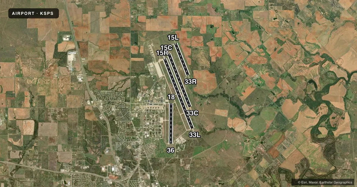
Airport sketch
Runways drawn to scale from FAA survey coordinates, rendered over satellite imagery. Not for navigation.
Approaches & charts
ILS · 2
Services on the field
Fuel grades, oxygen, maintenance, ramp storage and lighting — as declared to the FAA by the airport operator.
Fuel & services
- Fuel
- 100LLA
- Oxygen (bottled)
- Not available
- Airframe repair
- Minor
- Power plant repair
- Minor
Ramp & ground
- Transient storage
- Tie-down
- Landing fee
- No fee published
- Customs
- Not available
- Lighting schedule
- SEE RMK
- Beacon schedule
- SS-SR
- Beacon
- White / Green (civil land)(WG)
- Wind indicator
- Lighted
- Segmented circle
- No
Fuel & FBOs
Cheapest 100LL and Jet A on the field and nearby. Always confirm with the FBO before taxi.
Airport notes
Surface conditions, obstructions, local procedures, lighting outages and other notes published with each FAA cycle.
General notes
- TRAN ALERT: OPR 1200-0200Z++ WKD; 1800-2300Z++ SUN, CLSD SAT AND HOL.
- RSTD: PPR, 24 HR PN RQR, CTC AFLD OPS DSN 736-2180/6474, C940-676-2180/6474.
- DURING PERIODS WHEN CTL TWR IS CLSD EXERCISE CAUTION WHEN TAXIING; THE CIVIL ARPT IS LCTD TO THE S AND THE MIL RAMP IS LCTD TO THE W OF THE RWYS. FLD COND NOTAM (FICON) (RSC/RCR) NOT RPRTD WHEN TWR CLSD.
- RSTD: TRAN ACFT LTD TO ONE APCH TO A FULL STOP LDG AND MUST TAXI TO PRKG DURG STU TRNG.
- MIGRATORY BIRD ACTIVITY ON & INVOF ARPT FM OCT-APR.
- CAUTION: MIL ARPT CONDUCTS HI PERFORMANCE JET TRNG IN A HI DENSITY ENVIRONMENT WITHIN 95 NM OF KSPS, 1200-0200Z++ MON-FRI TO FL390, AND WHEN TWR HR EXTN BY NOTAM, OCCASIONALLY SAT AND SUN.
- (A89) LC CALL TO FSS 855-5574.
- A-GEAR: MA-1A RWY 15R-33L NOT RAISED, UNLESS 80TH FTW IS FLYING, RQR 30 MIN PN WHEN TWR OPR.
- MISC: BASE OPS 1200-0200Z++ WKD; 1800-2300Z++ SUN; CLSD SAT AND HOL.
- DUE TO CLOSE PROXIMITY OF RWYS 33L & 33C USE VIGILANCE WITH MONITOR GND TRACK FOR THE HI-TACAN RWY 33C APCH.
- SERVICE-LGT: RWY 15R-33L PAPI RRP AND ILS RPI NOT COINCIDENTAL.
- RSTD: ALL TRAN ACFT MUST BE CHOCKED 30 MIN PRIOR TO TRANS ALERT CLOSING; PPR EXPIRES 30 MIN PRIOR TO AFLD CLOSING.
- CAUTION: DO NOT CONFUSE PARL TWY WITH RWY 15R-33L.
- MISC: AETC ACFT EXP REDUCED RWY SEPARATION. DAY/VFR, SIMILAR TYPE ACFT 3000 FT, DISSIMILAR TYPE ACFT 6000 FT, NIGHT 6000 FT ALL AETC ACFT. TRAN AETC ACFT NOTIFY TWR ON INITIAL CTC IF REDUCED RWY SEPARATION IS NOT DESIRED.
- MISC: MIL WX ADVSY/WARNING AVBL O/R-METRO.
- SERVICE - TRAN ALERT: OPR 1130 -0300Z++ WKD; 1800-2300++ SUN; CLSD SAT AND HOL. QUALIFIED WEAPONS/MUNITIONS PERS NOT AVBL TO SAFE FTR TYPE ACFT.
- JASU: 3(AM32-95) 1(MC-1) 3(AM/32A-86D).
- FLUID: SP PRESAIR LOX.
- SERVICE-OIL JOAP RESULTS AVBL 1345-2100Z++ WKD EXC HOL.
- MISC: CLASS D AIRSPACE EFF 1130-0300Z++ MON-FRI; 1800-2300Z++ SUN; EXC HOL; OT CLASS E.
- CAUTION: ATC PERS IAW THE COOPERATIVE WX WATCH (CWW) WILL ALERT WX PERS ON ANY UNREPORTED WX COND THAT COULD AFFECT FLT SAFETY.
- CAUTION: MIL ARPT CONDUCTS HI PER JET TRNG IN A HI DENSITY ENVIRONMENT MON-FRI 1200-0200Z++ AND WHEN TWR HR EXTN BY NOTAM, OCNL SAT AND SUN.
- MISC: EXPECT NO AF SVC WHILE PRK AT THE RGNL ARPT.
- MISC: CTC BASE TAXI DSN 736-1843 C940-676-1843, OR U-DRIVE DSN 736-6813 C940-676-6813 PRIOR TO ARR.
- SERVICE-FUEL: A++.
- AFLD OPS FLT/COMMAND POST AT C940-676-2616.
- CD PHONE: 940-676-8354 (MON-FRI 1200-0200Z++, SUN 1800-2300Z++: CLSD SAT AND HOL, OT CTC FSS OR FORT WORTH ARTCC 817-858-7584).
- MISC: FOR INFO ABT THE WICHITA FALLS MUNI ARR PROCS VISIT: WWW.SHEPPARD.AF.MIL/CONTACT/SHARE-THE-AIR.
- ILS/RADAR: ILS OR LOC/DME - ILS 15C NOT AVBL.
- CAUTION: RWY 15C/33C AND RWY 15R/33L OVERRUNS HIGH POTENTIAL FOR FOD.
- SERVICE-LGT: RWY 15C/33C LED LGT IN USE.
- MISC: WHEN RWY 15C IN USE, TWY K AND L CLSD EXC MIL BASE ASGN ACFT. WHEN RWY 33C IN USE, TWY K AND L CLSD EXC ACFT WITH WINGSPAN LESS THAN 133 FT.
Lighting notes
- WHEN ATCT CLSD ACTVT MALSR RWY 33L - CTAF.
Approach & departure obstructions
- 15RRAIL OTS UFN.
Other notes
- TPA: 800 FT AGL LGT ACFT, 800 FT AGL, 1300 FT AGL CONVENTIONAL & JET, RWY 15R/33L 1800 FT AGL OVERHEAD.
- MANAGERFBO 940-855-5460.
VFR map & nearby airports
VFR sectional. Tap any ICAO chip to open that airport.
Key facts · KSPS
Answer card- ICAO
- KSPS
- Name
- SHEPPARD AFB/WICHITA FALLS MUNI
- Location
- WICHITA FALLS, TEXAS
- Elevation
- 1,019.1 ft MSL
- Traffic pattern altitude
- 2,019.1 ft MSL (1,000 AGL)
- Control tower
- Towered · OPR 1200-0200Z++ MON-FRI; 1800-2300Z++ SUN; CLSD SAT AND HOL, OT USE CTAF.
- Total runways
- 4
- Longest runway
- 15R/33L · 13,100 ft
- Published ILS approaches
- 2
- Published frequencies
- 18
- Magnetic variation
- 5°
- Current flight rules
- VFR
- Current wind
- 180° at 7 kt
- Favored runway now
- RWY 18
KSPS sits in Wichita Falls, Texas. Field elevation is 1,019.1 ft MSL. The airport has four runways. The longest is 15R/33L at 13,100 ft. Runway 15C/33C is closed, so plan around the active pavement that is actually available. The field has a control tower. Tower hours are 1200-0200Z Monday through Friday. It is 1800-2300Z Sunday. It is closed Saturday and holidays, so use CTAF outside tower hours.
Two ILS approaches are published. They serve runway ends 15C and 33L. Pattern altitude is not published in the standard way for this field. The published remarks call for 800 ft AGL for light aircraft. They also note 800 ft AGL and 1,300 ft AGL for conventional and jet aircraft. Overhead runway 15R/33L is 1,800 ft AGL. That matters here because this is a busy military and civil mix with special transient rules. Solo student operations are not authorized. Transient aircraft also have arrival and parking requirements that need a close read in the current Chart Supplement.
Wichita Falls Regional Airport is the on-field FBO. It carries 100LL, Jet A and Jet A Prist. Expect no Air Force service while parked at the regional airport. The remarks also warn not to confuse the parallel taxiway with runway 15R/33L. If you need clearance delivery help, the remarks give a Fort Worth ARTCC phone number when flight service is not available.