METAR & TAF KSDM
Current METAR
Observed 12:53Z
KSDM 271253Z AUTO 00000KT 9SM OVC007 22/19 A2993 RMK AO2 SLP129 T02170194
- Wind
- 000° @ 0 kt
- Visibility
- 9 SM
- Temp / Dew
- 22°C / 19°C
- Altimeter
- 29.93 inHg
- Clouds
- OVC
- Density alt
- 1,480 ft
- Ceiling
- 700 ft AGL
- Rules
- IFR
Airport info & contacts
Manager on record, flight service, ARTCC, attendance schedule and pattern altitude — published by the FAA and refreshed every 28 days.
Location
- From city
- 13 NM SE
- VFR sectional
- LOS ANGELES
- ARTCC
- ZLA · LOS ANGELES
- NOTAM facility
- SDM (NOTAM-D)
Airport manager
- Name
- ANDY SCHWARTZ
- Phone
- 619-424-0456
- Address
- 1424 CONTINENTAL ST, SAN DIEGO CA 92154
Flight service · Hours
- FSS SAN
- SAN DIEGO1-800-WX-BRIEF
- Attendance
- 0900-1700
Frequencies
Tap any row to copy the frequency to your clipboard.
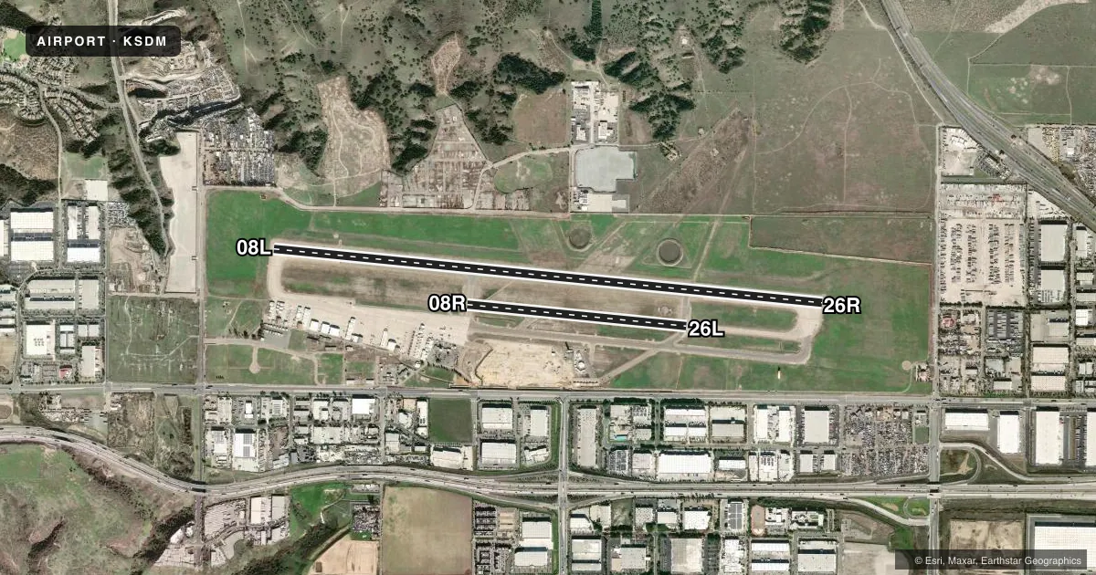
Runways & pattern
Full pagePattern entry · RWY 08L
LEFT TRAFFIC| Runway | Heading (°M) | Length | Surface | Traffic |
|---|---|---|---|---|
| 08L/26R | 82° / 262° | 7,972 ft | ASPH-CONC | 26R R |
| 08R/26L | 82° / 262° | 3,185 ft | ASPH | 08R R |
Runway end performance
| End | TORA | TODA | ASDA | LDA | VGSI | Approach lights | Obstruction |
|---|---|---|---|---|---|---|---|
| 08L | — | — | — | — | PAPI 4-box left(3°) | — | — |
| 26R | — | — | — | — | PAPI 4-box left(4°) | — | — |
Declared distances in feet. TORA = takeoff run available, TODA = takeoff distance, ASDA = accelerate-stop, LDA = landing distance.
Airport sketch
Runways drawn to scale from FAA survey coordinates, rendered over satellite imagery. Not for navigation.
Approaches & charts
Services on the field
Fuel grades, oxygen, maintenance, ramp storage and lighting — as declared to the FAA by the airport operator.
Fuel & services
- Fuel
- 100LLAA+
- Oxygen (bottled)
- HIGH/LOW
- Oxygen (bulk)
- HIGH/LOW
- Airframe repair
- Major
- Power plant repair
- Major
- Other services
- AFRT,AVNCS,CARGO,CHTR,INSTR,PAJA,RNTL,SALES
Ramp & ground
- Transient storage
- Tie-down
- Landing fee
- No fee published
- Customs
- Not available
- Lighting schedule
- SEE RMK
- Beacon schedule
- SS-SR
- Beacon
- White / Green (civil land)(WG)
- Wind indicator
- Lighted
- Segmented circle
- Yes
Fuel & FBOs
Cheapest 100LL and Jet A on the field and nearby. Always confirm with the FBO before taxi.
Airport notes
Surface conditions, obstructions, local procedures, lighting outages and other notes published with each FAA cycle.
General notes
- BE ALERT TO ARPT BDRY ONE MILE NORTH FM MEXICAN/USA INTL BORDER.
- NO ENGINE OPNS ON RAMPS EXCEPT AS NECESSARY FOR ARRIVALS/DEPARTURES.
- PARA JUMPING ON AIRPORT AND 3 MILES EAST.
- BE ALERT TO HIGH TERRAIN 3,566 FT. MSL SIX MILES EAST OF AIRPORT.
- BE ALERT WHEN DEPARTING ON RY 08L AT NIGHT DUE TO RISING TERRAIN TO THE EAST.
- NOISE SENSITIVE AREAS APPROX 1 MILE WEST OF AIRPORT, 1/2 MILE NORTHWEST, AND 2 MILES NORTH.
- TWY G WEST OF TWY B RESTRICTED TO AIRCRAFT WITH WINGSPANS OF 133 FT OR LESS.
- AVOID DCT OVERFLIGHT OF PIO PICO ENERGY CENTER BLO 2000 FT AGL, 3 NM EAST OF AP.
- FOR CD WHEN ATCT CLSD CTC SOCAL APCH AT 800-448-3724.
Lighting notes
- ACTVT REIL RWY 08L, PAPI RWY 08L & RWY 26R, HIRL RWY 08L/26R, AND MIRL RWY 08R/26L - CTAF.
Fuel notes
- A+FOR JET FUEL AFT HRS CALL FBO AT 619-671-9222; FEE FOR CALLOUT. MIL FUEL AVBL BY CALLING 619-671-9222.
Runway surface & condition
- 08R/26LOPERATOR PERMITS ONLY 12500 LBS.
Approach & departure obstructions
- 26RRWY 26R PAPI UNUSABLE BYD 3 NM.
Other notes
- <TPA: RWY 8L-26R 1000'AGL; 8R-26L 600'AGL.
VFR map & nearby airports
VFR sectional. Tap any ICAO chip to open that airport.
Key facts · KSDM
Answer card- ICAO
- KSDM
- Name
- BROWN FLD MUNI
- Location
- SAN DIEGO, CALIFORNIA
- Elevation
- 526.1 ft MSL
- Traffic pattern altitude
- 1,526.1 ft MSL (1,000 AGL)
- Control tower
- Towered · 0800-2000
- Total runways
- 2
- Longest runway
- 08L/26R · 7,972 ft
- Published ILS approaches
- 0
- Published frequencies
- 13
- Magnetic variation
- 14°
- Current flight rules
- IFR
- Current wind
- 000° at 0 kt
- Favored runway now
- –
Brown Field Muni sits in San Diego, California. Field elevation is 526.1 ft MSL. The airport has two runways. The longest is 08L/26R at 7,972 ft. The shorter runway is 08R/26L at 3,185 ft. The tower is open 0800-2000. No ILS approaches are published here. Pattern altitude is 1,000 ft AGL for 08L/26R. Pattern altitude is 600 ft AGL for 08R/26L.
This is a busy border-area field with SoCal Class B procedures in play. First-time arrivals should be ready for the radio work. They should also watch terrain near the airport. Published remarks call out rising terrain east of runway 08L at night. They also note high terrain 3,566 ft MSL about 6 miles east. Noise-sensitive areas sit west, northwest and north of the airport. Parachute jumping also occurs on the airport and 3 miles east. Runway lighting is pilot-controlled from CTAF.
Two on-field FBOs are listed. First Flight Corporation carries 100LL, Jet A and Jet A Prist. Air Center San Diego carries 100LL, Jet A and Jet A Prist. The airport remarks also say no engine operations are allowed on ramps except as needed for arrivals and departures. Runway 08R/26L is limited to aircraft with a gross weight of 12,500 lb. Taxiway G west of Taxiway B is limited to aircraft with wingspans of 133 ft or less.