METAR & TAF KRVS
Current METAR
Observed 15:53Z
KRVS 271553Z 22008KT 10SM CLR 33/22 A2990 RMK AO2 SLP124 T03330217
- Wind
- 220° @ 8 kt
- Visibility
- 10 SM
- Temp / Dew
- 33°C / 22°C
- Altimeter
- 29.90 inHg
- Clouds
- CLR
- Density alt
- 2,976 ft
- Ceiling
- Unlimited
- Rules
- VFR
Airport info & contacts
Manager on record, flight service, ARTCC, attendance schedule and pattern altitude — published by the FAA and refreshed every 28 days.
Location
- From city
- 5 NM S
- VFR sectional
- KANSAS CITY
- ARTCC
- ZKC · KANSAS CITY
- NOTAM facility
- RVS (NOTAM-D)
Airport manager
- Name
- AUSTIN WHEELER
- Phone
- 918-299-5886
- Address
- 8303 S. HANGAR RD., TULSA OK 74132
Flight service · Hours
- FSS MLC
- MC ALESTER1-800-WX-BRIEF
- Attendance
- 0600 - 2200
Frequencies
Tap any row to copy the frequency to your clipboard.
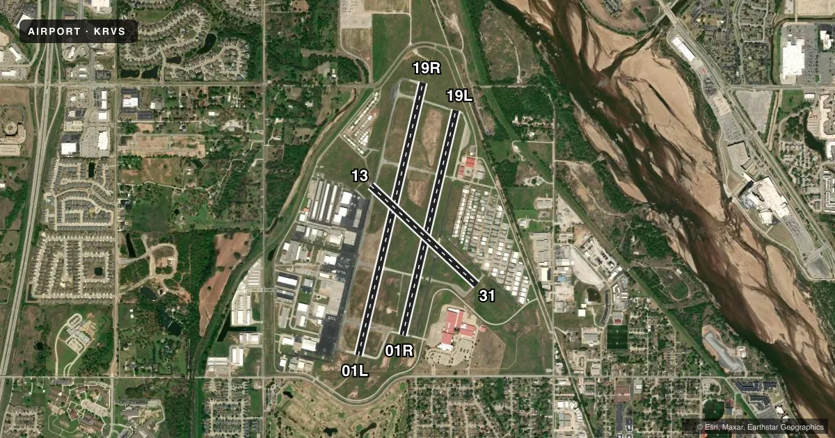
Runways & pattern
Full pagePattern entry · RWY 19R
RIGHT TRAFFIC| Runway | Heading (°M) | Length | Surface | Traffic |
|---|---|---|---|---|
| 01L/19RFavored | 10° / 190° | 5,101 ft | ASPH | 19R R |
| 01R/19L | 10° / 190° | 4,205 ft | ASPH | 01R R |
| 13/31 | 130° / 310° | 2,639 ft | ASPH | 31 R |
Runway end performance
| End | TORA | TODA | ASDA | LDA | VGSI | Approach lights | Obstruction |
|---|---|---|---|---|---|---|---|
| 01L | — | — | — | — | PAPI 4-box left(3°) | — | 31', trees, 1450' from thr, 0' R of cntrln, slope 40 |
| 19R | — | — | — | — | PAPI 4-box left(3.2°) | — | 36', trees, 1076' from thr, 151' R of cntrln, slope 24 |
| 01R | — | — | — | — | PAPI 4-box left(2.83°) | — | — |
| 19L | — | — | — | — | PAPI 4-box left(2.83°) | — | 48', pline, 826' from thr, 0' R of cntrln, slope 13 |
| 13 | — | — | — | — | — | — | 71', trees, 1329' from thr, 0' R of cntrln, slope 15 |
Declared distances in feet. TORA = takeoff run available, TODA = takeoff distance, ASDA = accelerate-stop, LDA = landing distance.
Airport sketch
Runways drawn to scale from FAA survey coordinates, rendered over satellite imagery. Not for navigation.
Approaches & charts
ILS · 1
Services on the field
Fuel grades, oxygen, maintenance, ramp storage and lighting — as declared to the FAA by the airport operator.
Fuel & services
- Fuel
- 100LLAA+
- Oxygen (bottled)
- Low pressure
- Airframe repair
- Major
- Power plant repair
- Major
- Other services
- AMB,AVNCS,CHTR,INSTR,RNTL,SALES
Ramp & ground
- Transient storage
- Tie-down
- Hangar
- Landing fee
- No fee published
- Customs
- Not available
- Lighting schedule
- SEE RMK
- Beacon schedule
- SS-SR
- Beacon
- White / Green (civil land)(WG)
- Wind indicator
- Lighted
- Segmented circle
- Yes
Fuel & FBOs
Cheapest 100LL and Jet A on the field and nearby. Always confirm with the FBO before taxi.
Airport notes
Surface conditions, obstructions, local procedures, lighting outages and other notes published with each FAA cycle.
General notes
- NE, NW & SW RAMPS, PTNS OF TXL CC, DD & GG NOT VSB FM ATCT.
- NOISE ABATEMENT: TURNS ON DEP PRIOR TO 1500 FT MSL NA.
- BIRDS ON & INVOF ARPT.
- TXL BB & NW PVT HNGR AREA TXL 20 FT WIDE.
- NE & NW PVT HNGR AREA WINGSPAN GTR THAN 49 FT NA; TXL WT LMT 12500 LB.
Lighting notes
- WHEN ATCT CLSD ACTVT MIRL RWY 01R/19L & 13/31; HIRL RWY 01L/19R; TWY H, L, T & Z; TXL DD - CTAF. HIRL RWY 01L/19R PRESET MED INTST; INCR INTST - CTAF.
Approach & departure obstructions
- 19L8 FT ROAD 200 FT FM RWY THR, BOTH SIDES.
- 13L TURN ON DEP BFR 1500 FT MSL NA.
- 31MNTN TPA UNTIL ABEAM AER ON DOWNWIND LEG.
- 01R48 FT PLINE 826 FT FM RWY 19L END CREATES 20:1 APCH CLNC SLP TO DTHR.
Other notes
- 1AFT HR PPR.
- 01L/19RONLY CNTR 80 FT GRVD.
VFR map & nearby airports
VFR sectional. Tap any ICAO chip to open that airport.
Key facts · KRVS
Answer card- ICAO
- KRVS
- Name
- TULSA RIVERSIDE
- Location
- TULSA, OKLAHOMA
- Elevation
- 638.2 ft MSL
- Traffic pattern altitude
- 1,638.2 ft MSL (1,000 AGL)
- Control tower
- Towered · 0700-2200
- Total runways
- 3
- Longest runway
- 01L/19R · 5,101 ft
- Published ILS approaches
- 1
- Published frequencies
- 9
- Magnetic variation
- 3°
- Current flight rules
- VFR
- Current wind
- 220° at 8 kt
- Favored runway now
- RWY 19R
Tulsa Riverside is in Tulsa, Oklahoma. Field elevation is 638.2 ft MSL. The airport has three asphalt runways. The longest is 5,101 ft on 01L/19R. The tower is open 0700-2200. One ILS approach is published for runway 01L. Pattern altitude is not published, so use the standard 1,000 ft AGL for light piston traffic unless the current Chart Supplement says otherwise.
This field has two on-field FBOs. Riverside Jet Center carries AVGAS 100LL and Jet A. Christiansen Aviation carries AVGAS 100LL and Jet A Prist. For after-hours operations, prior permission is required. The airport also has published noise abatement. Turns on departure are not authorized before 1,500 ft MSL. That matters here because the field sits in a busy metro area with towered traffic and multiple runway choices.
There are a few operational items to plan around. Runway 01R has a displaced-threshold issue tied to a power line near the 19L end. Runway 01L/19R is grooved only in the center 80 ft. Birds are reported on and near the airport. The northeast and northwest private hangar areas do not allow wingspans greater than 49 ft. Taxiway weight limit is 12,500 lb. When the tower is closed, runway and taxiway lighting is activated on CTAF. Check the current Chart Supplement for any details before you go.