METAR & TAF KRID
Current METAR
Observed 13:15Z
KRID 121315Z AUTO 27007KT 10SM BKN008 OVC022 21/19 A2995 RMK AO2
- Wind
- 270° @ 7 kt
- Visibility
- 10 SM
- Temp / Dew
- 21°C / 19°C
- Altimeter
- 29.95 inHg
- Clouds
- OVC
- Density alt
- 2,096 ft
- Ceiling
- 800 ft AGL
- Rules
- IFR
Airport info & contacts
Manager on record, flight service, ARTCC, attendance schedule and pattern altitude — published by the FAA and refreshed every 28 days.
Location
- From city
- 5 NM SE
- VFR sectional
- CINCINNATI
- ARTCC
- ZID · INDIANAPOLIS
- NOTAM facility
- HUF (NOTAM-D)
Airport manager
- Name
- RODNEY MAYSE
- Phone
- 765-983-7296
- Address
- 5169 SR 227 S., RICHMOND IN 47374
Flight service · Hours
- FSS HUF
- TERRE HAUTE1-800-WX-BRIEF
- Attendance
- 0800-1745
Frequencies
Tap any row to copy the frequency to your clipboard.
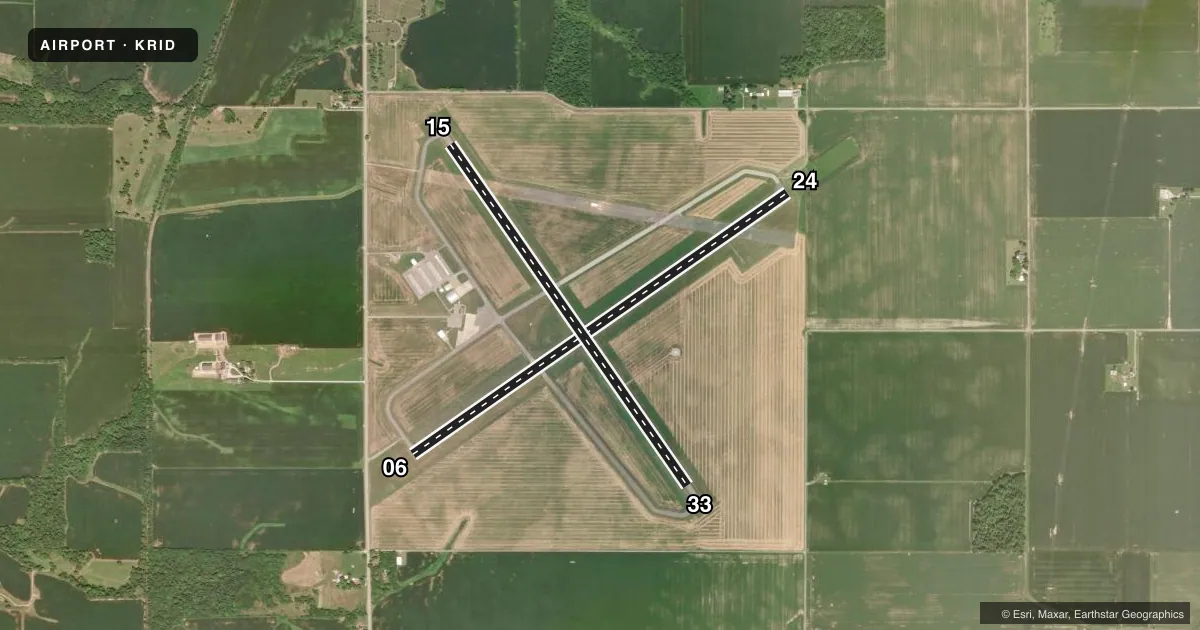
Runways & pattern
Full pagePattern entry · RWY 24
LEFT TRAFFIC| Runway | Heading (°M) | Length | Surface | Traffic |
|---|---|---|---|---|
| 06/24Favored | 52° / 232° | 5,502 ft | ASPH | Standard L |
| 15/33 | 142° / 322° | 4,999 ft | ASPH | Standard L |
Runway end performance
| End | TORA | TODA | ASDA | LDA | VGSI | Approach lights | Obstruction |
|---|---|---|---|---|---|---|---|
| 06 | 5,500' | 5,500' | 5,500' | 5,200' | PAPI 4-box left(3°) | — | 18', road, 320' from thr, 510' R of cntrln, slope 6 |
| 24 | 5,500' | 5,500' | 5,500' | 5,500' | PAPI 4-box left(3°) | — | 72', trees, 1740' from thr, 730' R of cntrln, slope 21 |
| 33 | — | — | — | — | — | — | 66', trees, 2550' from thr, 15' R of cntrln, slope 35 |
Declared distances in feet. TORA = takeoff run available, TODA = takeoff distance, ASDA = accelerate-stop, LDA = landing distance.
Airport sketch
Runways drawn to scale from FAA survey coordinates, rendered over satellite imagery. Not for navigation.
Approaches & charts
Services on the field
Fuel grades, oxygen, maintenance, ramp storage and lighting — as declared to the FAA by the airport operator.
Fuel & services
- Fuel
- 100LLA
- Airframe repair
- Minor
- Power plant repair
- Minor
Ramp & ground
- Transient storage
- Tie-down
- Hangar
- Landing fee
- No fee published
- Customs
- Not available
- Lighting schedule
- SEE RMK
- Beacon schedule
- SS-SR
- Beacon
- White / Green (civil land)(WG)
- Wind indicator
- Lighted
- Segmented circle
- No
Fuel & FBOs
Cheapest 100LL and Jet A on the field and nearby. Always confirm with the FBO before taxi.
Airport notes
Surface conditions, obstructions, local procedures, lighting outages and other notes published with each FAA cycle.
Lighting notes
- ACTVT REIL RWY 06; PAPI RWY 06 & 24; MIRL RWY 06/24 & RWY 15/33 - CTAF.
Approach & departure obstructions
- 1510 FT CROPS 105 FT L OF RWY END CNTRLN.
- 3310 FT CROPS 100 FT L & R OF RWY END CNTRLN.
- 06APCH RATIO 34:1 TO DTHR.
- 24APCH RATIO 24:1 TO THR.
Other notes
- MANAGERAFT HR 765-993-4139.
VFR map & nearby airports
VFR sectional. Tap any ICAO chip to open that airport.
Key facts · KRID
Answer card- ICAO
- KRID
- Name
- RICHMOND MUNI
- Location
- RICHMOND, INDIANA
- Elevation
- 1,139.8 ft MSL
- Traffic pattern altitude
- 2,139.8 ft MSL (1,000 AGL)
- Control tower
- Non-towered (use CTAF)
- Total runways
- 2
- Longest runway
- 06/24 · 5,502 ft
- Published ILS approaches
- 0
- Published frequencies
- 5
- Magnetic variation
- 3°
- Current flight rules
- IFR
- Current wind
- 270° at 7 kt
- Favored runway now
- RWY 24
Richmond Muni sits in Richmond, Indiana. The field elevation is 1,139.8 ft MSL. It has two asphalt runways. The longest is runway 06/24 at 5,502 ft. There is no control tower. Pattern altitude is not published, so use the standard 1,000 ft AGL for light piston operations unless the current Chart Supplement says otherwise.
No ILS approaches are published here. That makes the visual setup and local weather check more important before arrival. The airport uses CTAF 122.7 and UNICOM 122.7. The on-field FBO is Richmond Municipal Airport. It carries 100LL, Jet A and Jet A Prist. Call (765) 983-7296 for current service details.
A few published remarks matter for planning. Runway 06 has end identifier lights activated by CTAF. Runways 06/24 and 15/33 have PAPI. Medium intensity runway lights are on both runways and are CTAF-activated. There are also crop obstructions near the ends of runways 15 and 33. The approach clearance slopes on 06 and 24 are also published, so pay attention to threshold setup on those ends. After hours contact is listed in the Chart Supplement remarks. Richmond is an uncontrolled field. Expect self-announce traffic. Keep a close eye on runway selection, especially with the two crossing asphalt strips.