METAR & TAF KPTK
Current METAR
Observed 20:53Z
KPTK 272053Z 27010G20KT 10SM -RA FEW025 SCT050 BKN100 OVC200 28/19 A2980 RMK RAE13B45 SLPNO T02830193
- Wind
- 270° @ 10G20 kt
- Visibility
- 10 SM
- Temp / Dew
- 28°C / 19°C
- Altimeter
- 29.80 inHg
- Clouds
- OVC
- Density alt
- 2,925 ft
- Ceiling
- 10,000 ft AGL
- Rules
- VFR
Airport info & contacts
Manager on record, flight service, ARTCC, attendance schedule and pattern altitude — published by the FAA and refreshed every 28 days.
Location
- From city
- 5 NM W
- VFR sectional
- DETROIT
- ARTCC
- ZOB · CLEVELAND
- NOTAM facility
- PTK (NOTAM-D)
Airport manager
- Name
- CHERYL BUSH
- Phone
- 248-666-3900
- Address
- 6500 PATTERSON PKWY, WATERFORD MI 48327-1683
Flight service · Hours
- FSS LAN
- LANSING1-800-WX-BRIEF
- Attendance
- ALL
Frequencies
Tap any row to copy the frequency to your clipboard.
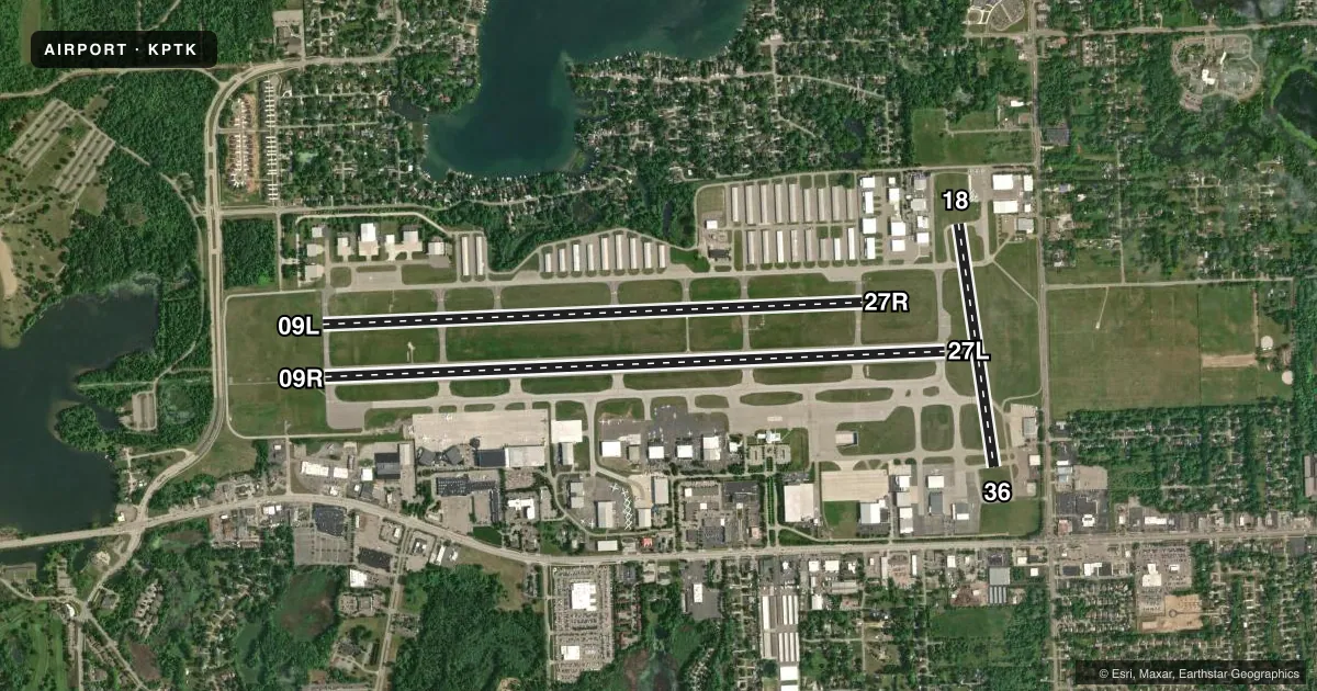
Runways & pattern
Full pagePattern entry · RWY 27L
LEFT TRAFFIC| Runway | Heading (°M) | Length | Surface | Traffic |
|---|---|---|---|---|
| 09R/27LFavored | 81° / 261° | 6,521 ft | ASPH | Standard L |
| 09L/27R | 81° / 261° | 5,676 ft | ASPH | Standard L |
| 18/36 | 165° / 345° | 2,582 ft | ASPH | Standard L |
Runway end performance
| End | TORA | TODA | ASDA | LDA | VGSI | Approach lights | Obstruction |
|---|---|---|---|---|---|---|---|
| 09R | 6,520' | 6,520' | 6,520' | 6,520' | PAPI 4-box left(3°) | MALSR | — |
| 27L | 6,520' | 6,520' | 6,520' | 6,520' | PAPI 4-box left(3°) | — | — |
| 09L | 5,675' | 5,675' | 5,675' | 5,675' | PAPI 4-box left(3°) | — | — |
| 27R | 5,675' | 5,675' | 5,675' | 5,675' | PAPI 4-box left(3°) | — | — |
| 36 | — | — | — | — | PAPI 2-box left(3°) | — | — |
Declared distances in feet. TORA = takeoff run available, TODA = takeoff distance, ASDA = accelerate-stop, LDA = landing distance.
Airport sketch
Runways drawn to scale from FAA survey coordinates, rendered over satellite imagery. Not for navigation.
Approaches & charts
ILS · 1
Services on the field
Fuel grades, oxygen, maintenance, ramp storage and lighting — as declared to the FAA by the airport operator.
Fuel & services
- Fuel
- 100LLA
- Oxygen (bottled)
- Not available
- Oxygen (bulk)
- High pressure
- Airframe repair
- Major
- Power plant repair
- Major
- Other services
- AFRT,AVNCS,CARGO,CHTR,INSTR,RNTL,SALES
Ramp & ground
- Transient storage
- Tie-down
- Hangar
- Landing fee
- Yes
- Customs
- Not available
- Lighting schedule
- SEE RMK
- Beacon schedule
- SS-SR
- Beacon
- White / Green (civil land)(WG)
- Wind indicator
- Lighted
- Segmented circle
- No
Fuel & FBOs
Cheapest 100LL and Jet A on the field and nearby. Always confirm with the FBO before taxi.
Airport notes
Surface conditions, obstructions, local procedures, lighting outages and other notes published with each FAA cycle.
General notes
- ATCT UNA TO SEE MORE THAN 200 FT SOUTH OF RWY 36 THR AND TWY A2 BTN TWYS A & B.
- BIRDS & DEER ON & INVOF ARPT.
- SEAPLANE TKOFS & LDGS PROHIBITED ON LAKE ANGELUS 4.5 NM ENE.
- FOR CD WHEN ATCT IS CLSD CTC DETROIT APCH AT 734-955-1404.
- 41D SPB LCTD 1.4 NM WEST. ACFT OPRG AT 41D WILL ANNC INTNS ON PTK CTAF.
- ARFF PSNL MNT CTAF WHEN ATCT IS CLSD.
Lighting notes
- WHEN ATCT CLSD ACTVT MALSR RWY 09R; REIL RWY 27L; PAPI RWY 09R & 27L; HIRL RWY 09R/27L - CTAF.
Runway surface & condition
- 09L/27RPCR VALUE: 400/F/A/X/T
- 09R/27LPCR VALUE: 400/F/A/X/T
- 09L/27RRWY 09L/27R NOT AVBL FOR PART 121/PART 380 OPS WITH SKED PAX CARRYING OPS MORE THAN 9 PAX SEATS AND NON-SKED PAX CARRYING OPS MORE THAN 30 PAX SEATS.
- 18/36RWY 18/36 NOT AVBL FOR PART 121/PART 380 OPS WITH SKED PAX CARRYING OPS MORE THAN 9 PAX SEATS AND NON-SKED PAX CARRYING OPS MORE THAN 30 PAX SEATS. DAY VFR USE AND CLSD TO ACFT OVR 12500 LBS.
Approach & departure obstructions
- 27LPAPI UNUSBL BYD 8 DEGS RIGHT OF CNTRLN.
Other notes
- CLSD TO SKEDD ACR OPS GTR THAN 9 PAX SEATS. 48 HR PPR FOR INDEX B SVC & UNSKED ACR OPS GTR THAN 30 PAX SEATS - CALL AMGR.
- LDG FEE FOR ACFT OVR 12500 LBS; AFT HRS/WKEND FEES APPLY TO ALL ACFT.
- CUST FEES APPLY TO ACFT OVR 10000 LBS; CTC US CUST 0700-2200 MON-FRI AT 248-666-7717; OTR TIMES MNM 3 HRS PN AT 734-942-9000.
VFR map & nearby airports
VFR sectional. Tap any ICAO chip to open that airport.
Key facts · KPTK
Answer card- ICAO
- KPTK
- Name
- OAKLAND COUNTY INTL
- Location
- PONTIAC, MICHIGAN
- Elevation
- 980.6 ft MSL
- Traffic pattern altitude
- 1,980.6 ft MSL (1,000 AGL)
- Control tower
- Towered · 0600-0000
- Total runways
- 3
- Longest runway
- 09R/27L · 6,521 ft
- Published ILS approaches
- 1
- Published frequencies
- 10
- Magnetic variation
- 7°
- Current flight rules
- VFR
- Current wind
- 270° at 10 kt
- Favored runway now
- RWY 27L
KPTK is Oakland County Intl in Pontiac, Michigan. The field sits at 980.6 ft MSL. It has three asphalt runways. The longest is 09R/27L at 6,521 ft. The tower is open from 0600 to 0000. One ILS approach is published for runway 09R. Pattern altitude is not published in the facts, so use the standard 1,000 ft AGL for light piston traffic unless the current Chart Supplement says otherwise.
This is a busy metro airport with mixed piston, turbine and jet traffic. The field is in the Detroit area, so expect close attention to ATC and be ready for frequency changes. When the tower is closed, use CTAF 120.5 for traffic calls. The published remarks also note limited tower visibility south of runway 36 and near taxiway A2 between taxiways A and B. Birds and deer are reported on and near the airport. Keep a sharp scan on taxi and final.
On the field, Maven by Midfield, PremierFBO, Royal Air, Pentastar Aviation, Elite Jet Center at Contact and Michigan Aviation all serve the airport. Confirm services by phone before arrival. Published remarks also note lighting procedures for tower-closed operations on runway 09R/27L. Check the current Chart Supplement for any operating limits, landing fee notes, or customs timing before you go.