METAR & TAF KPHK
KPHK does not publish a METAR.
Showing the nearest reporting station: KOBE (OKEECHOBEE COUNTY) · 30.1 NM away. Conditions at KPHK may differ.
METAR · KOBE
Observed 17:15Z
KOBE 271715Z AUTO 30006KT 10SM SCT036 SCT042 SCT049 34/26 A2991 RMK AO2
- Wind
- 300° @ 6 kt
- Visibility
- 10 SM
- Temp / Dew
- 34°C / 26°C
- Altimeter
- 29.91 inHg
- Clouds
- SCT
- Density alt
- 2,312 ft
- Ceiling
- Unlimited
- Rules
- VFR
Airport info & contacts
Manager on record, flight service, ARTCC, attendance schedule and pattern altitude — published by the FAA and refreshed every 28 days.
Location
- From city
- 3 NM SW
- VFR sectional
- MIAMI
- ARTCC
- ZMA · MIAMI
- NOTAM facility
- MIA (NOTAM-D)
Airport manager
- Name
- LAURA BEEBE
- Phone
- 561-471-7420
- Address
- 846 PALM BEACH INTL AIRPORT, WEST PALM BEACH FL 33406-1470
Flight service · Hours
- FSS MIA
- MIAMI1-800-WX-BRIEF
- Attendance
- 0800-1800
Frequencies
Tap any row to copy the frequency to your clipboard.
Runways & pattern
Full pagePattern entry · RWY 36
LEFT TRAFFICRunway end performance
| End | TORA | TODA | ASDA | LDA | VGSI | Approach lights | Obstruction |
|---|---|---|---|---|---|---|---|
| 18 | 4,069' | 4,069' | 4,119' | 4,016' | PAPI 2-box left(3°) | — | 40', trees, 1050' from thr, 150' R of cntrln, slope 21 |
| 36 | 4,016' | 4,016' | 4,170' | 4,069' | PAPI 2-box left(3°) | — | 27', trees, 885' from thr, 10' R of cntrln, slope 25 |
Declared distances in feet. TORA = takeoff run available, TODA = takeoff distance, ASDA = accelerate-stop, LDA = landing distance.
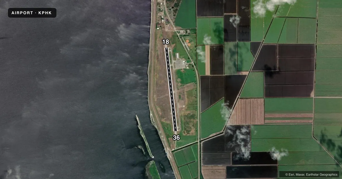
Airport sketch
Runways drawn to scale from FAA survey coordinates, rendered over satellite imagery. Not for navigation.
Approaches & charts
Services on the field
Fuel grades, oxygen, maintenance, ramp storage and lighting — as declared to the FAA by the airport operator.
Fuel & services
- Fuel
- 100LLA
- Oxygen (bottled)
- Not available
- Oxygen (bulk)
- Not available
- Airframe repair
- Not available
- Power plant repair
- Not available
- Other services
- PAJA
Ramp & ground
- Transient storage
- Tie-down
- Hangar
- Landing fee
- No fee published
- Customs
- Not available
- Lighting schedule
- SEE RMK
- Beacon schedule
- SS-SR
- Beacon
- White / Green (civil land)(WG)
- Wind indicator
- Lighted
Fuel & FBOs
Cheapest 100LL and Jet A on the field and nearby. Always confirm with the FBO before taxi.
Airport notes
Surface conditions, obstructions, local procedures, lighting outages and other notes published with each FAA cycle.
General notes
- BIRDS ON AND INVOF ARPT.
- ARPT SFC COND NOT RPRTD FOR ALL RWYS.
- FOR CD IF UNA TO CTC ON FSS FREQ, CTC PALM BEACH APCH AT 561-275-1430 OR 561-684-9047.
- FBO SVC FEE MAY APPLY.
- 24-HR PPR RQ FOR ALL ACFT EQUIPPED WITH WX MODIFICATION EQPT OR ACFT CPBL OF WX MODIFICATION AND/OR GEOENGINEERING BY CTC THE DEPT OF ARPT COMMUNICATIONS CNTR AT (561) 471-7420..
Lighting notes
- ACTVT MIRL RWY 18/36 - CTAF.
Approach & departure obstructions
- 18RY 18 APCH RATIO 28:1 AT DSPLCD THLD.
- 36RY 36 APCH RATIO 35:1 AT DSPLCD THLD.
Other notes
- THIS AIRPORT HAS BEEN SURVEYED BY THE NATIONAL GEODETIC SURVEY.
- 1SVC AFT HR - 561-626-9799.
VFR map & nearby airports
VFR sectional. Tap any ICAO chip to open that airport.
Key facts · KPHK
Answer card- ICAO
- KPHK
- Name
- PALM BEACH COUNTY GLADES
- Location
- PAHOKEE, FLORIDA
- Elevation
- 15.9 ft MSL
- Traffic pattern altitude
- 1,015.9 ft MSL (1,000 AGL)
- Control tower
- Non-towered (use CTAF)
- Total runways
- 1
- Longest runway
- 18/36 · 4,116 ft
- Published ILS approaches
- 0
- Published frequencies
- 4
- Magnetic variation
- 7°
- Current flight rules
- VFR
- Current wind
- 300° at 6 kt
- Favored runway now
- RWY 36
Palm Beach County Glades Airport sits in Pahokee, Florida. Field elevation is 15.9 ft MSL. The airport has one runway, 18/36, which is 4,116 ft long and paved with asphalt. There is no control tower. CTAF and UNICOM are both 122.8. Palm Beach Approach uses 125.2 and 317.4 for the area. No ILS approaches are published here.
Pattern altitude is not published. For light piston traffic, plan on the standard 1,000 ft AGL pattern unless local procedures or ATC say otherwise. Signature Aviation is on the field. It carries 100LL and Jet A. Call ahead at (561) 924-5253 if you need current service details.
A few published remarks matter for planning. Runway 18 and Runway 36 both have displaced-threshold obstacle notes, so pay attention to your arrival path. Medium intensity runway lights on 18/36 are activated by CTAF. Birds are reported on and near the airport. Airport surface condition is not reported for all runways, so get the latest picture before you go. If you need after-hours service, the published number is available in the Chart Supplement. This is a low-elevation field in flat country, so weather and traffic are usually the bigger planning items than terrain.