METAR & TAF KOWK
KOWK does not publish a METAR.
Showing the nearest reporting station: KWVL (WATERVILLE RGNL) · 13.6 NM away. Conditions at KOWK may differ.
METAR · KWVL
Observed 09:56Z
KWVL 120956Z AUTO 00000KT 6SM BR BKN070 20/20 A2967 RMK AO2 SLP048 T02000200
- Wind
- 000° @ 0 kt
- Visibility
- 6 SM
- Temp / Dew
- 20°C / 20°C
- Altimeter
- 29.67 inHg
- Clouds
- BKN
- Density alt
- 1,245 ft
- Ceiling
- 7,000 ft AGL
- Rules
- VFR
Airport info & contacts
Manager on record, flight service, ARTCC, attendance schedule and pattern altitude — published by the FAA and refreshed every 28 days.
Location
- From city
- 4 NM W
- VFR sectional
- MONTREAL
- ARTCC
- ZBW · BOSTON
- NOTAM facility
- BGR (NOTAM-D)
Airport manager
- Name
- RICHARD LABELLE
- Phone
- 207-634-2252
- Address
- PO BOX 7, NORRIDGEWOCK ME 04957
Flight service · Hours
- FSS BGR
- BANGOR1-800-WX-BRIEF
- Attendance
- MON-FRI · 0700-1400
- SAT-SUN · Unattended
Frequencies
Tap any row to copy the frequency to your clipboard.
Runways & pattern
Full pagePattern entry · RWY 15
LEFT TRAFFIC| Runway | Heading (°M) | Length | Surface | Traffic |
|---|---|---|---|---|
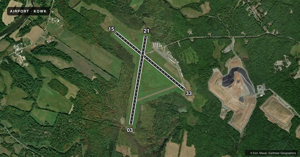
| 15/33 | 112° / 292° | 4,000 ft | ASPH | Standard L |
| 03/21 | 352° / 172° | 3,998 ft | ASPH | Standard L |
Runway end performance
| End | TORA | TODA | ASDA | LDA | VGSI | Approach lights | Obstruction |
|---|---|---|---|---|---|---|---|
| 15 | — | — | — | — | PAPI 2-box left(3°) | — | 35', tree, 767' from thr, 285' R of cntrln, slope 16 |
| 03 | — | — | — | — | — | — | 21', trees, 243' from thr, 121' R of cntrln, slope 2 |
| 21 | — | — | — | — | — | — | 69', trees, 790' from thr, 180' R of cntrln, slope 8 |
Declared distances in feet. TORA = takeoff run available, TODA = takeoff distance, ASDA = accelerate-stop, LDA = landing distance.
Airport sketch
Runways drawn to scale from FAA survey coordinates, rendered over satellite imagery. Not for navigation.
Approaches & charts
Services on the field
Fuel grades, oxygen, maintenance, ramp storage and lighting — as declared to the FAA by the airport operator.
Fuel & services
- Fuel
- 100LLMOGAS
- Oxygen (bottled)
- Not available
- Oxygen (bulk)
- Not available
- Airframe repair
- Major
- Power plant repair
- Major
- Other services
- INSTR,RNTL,SURV
Ramp & ground
- Transient storage
- Tie-down
- Landing fee
- No fee published
- Customs
- Not available
- Lighting schedule
- SEE RMK
- Beacon schedule
- SS-SR
- Beacon
- White / Green (civil land)(WG)
- Wind indicator
- Lighted
- Segmented circle
- Yes
Fuel & FBOs
Cheapest 100LL and Jet A on the field and nearby. Always confirm with the FBO before taxi.
Airport notes
Surface conditions, obstructions, local procedures, lighting outages and other notes published with each FAA cycle.
General notes
- BIRDS & DEER ON & INVOF ARPT.
- RWY 21 HAS 30 FT DROPOFF 100 FT FM END OF RWY.
- FOR CD CTC PORTLAND APCH AT 207-874-7320. WHEN PORTLAND APCH CLSD, CTC BOSTON ARTCC AT 603-879-6859.
Lighting notes
- ACTVT REIL RWY 15 & 33; PAPI RWY 15; MIRL RWY 15/33 - CTAF.
Fuel notes
- 100LL24 HR FUEL AVBL WITH MAJOR CREDIT CARD.
Approach & departure obstructions
- 03+10 FT -20 FT TREES & BRUSH 75 FT FM THR, 230-250 FT R OF CNTRLN.
- 1510 FT TREES, 90-175 FT FM RWY END, 130-250 FT R.
- 21+4-8 FT BRUSH 110-120 FT FM THR, 100 FT L & R OF CNTRLN; +25 FT TREES 100-175 FT FM THR, 185-250 FT L OF CNTRLN.
- 21MRKGS FADED. CNTRLN & THR BARS MISG.
- 03MRKGS FADED. CNTRLN & THR BARS MISG.
Other notes
- EXISTED PRIOR TO 1959.
- MANAGERARPT ADS: 603 AIRPORT RD.
- MANAGERALTN CTC: BRUCE HURLEY 207-449-2995.
VFR map & nearby airports
VFR sectional. Tap any ICAO chip to open that airport.
Key facts · KOWK
Answer card- ICAO
- KOWK
- Name
- CENTRAL MAINE/NORRIDGEWOCK
- Location
- NORRIDGEWOCK, MAINE
- Elevation
- 270.2 ft MSL
- Traffic pattern altitude
- 1,270.2 ft MSL (1,000 AGL)
- Control tower
- Non-towered (use CTAF)
- Total runways
- 2
- Longest runway
- 15/33 · 4,000 ft
- Published ILS approaches
- 0
- Published frequencies
- 4
- Magnetic variation
- 18°
- Current flight rules
- VFR
- Current wind
- 000° at 0 kt
- Favored runway now
- –
Central Maine/Norridgewock Airport sits in Norridgewock, Maine. Field elevation is 270.2 ft MSL. The airport has two asphalt runways. The longest is 4,000 ft on runway 15/33. There is no control tower. CTAF and UNICOM are both 122.8. No ILS approaches are published. Pattern altitude is not published, so use the standard 1,000 ft AGL pattern unless the current Chart Supplement says otherwise.
On the field, Central Maine Regional Airport carries 100LL and MOGAS. Twenty-four hour fuel is available with a major credit card for 100LL. That is useful for late arrivals or early departures. Runway 15 has a PAPI. Runways 15 and 33 have medium intensity runway lights. Use CTAF for lighting control. The published remarks also note faded markings on runways 03 and 21. Centerline and threshold bars are missing at both ends. Runway 21 has a 30 ft dropoff 100 ft from the runway end. Brush and trees are reported near the runway ends on 03, 15 and 21. Birds and deer are also reported on and near the airport. For clearance delivery, Portland Approach is listed in the remarks. Boston ARTCC is the backup when Portland Approach is closed.