METAR & TAF KMLD
KMLD does not publish a METAR.
Showing the nearest reporting station: KLGU (LOGAN-CACHE) · 30.1 NM away. Conditions at KMLD may differ.
METAR · KLGU
Observed 04:51Z
KLGU 120451Z AUTO 00000KT 10SM CLR 12/03 A3010 RMK AO2 SLP169 T01170028
- Wind
- 000° @ 0 kt
- Visibility
- 10 SM
- Temp / Dew
- 12°C / 3°C
- Altimeter
- 30.10 inHg
- Clouds
- CLR
- Density alt
- 5,001 ft
- Ceiling
- Unlimited
- Rules
- VFR
Airport info & contacts
Manager on record, flight service, ARTCC, attendance schedule and pattern altitude — published by the FAA and refreshed every 28 days.
Location
- From city
- 3 NM SW
- VFR sectional
- SALT LAKE CITY
- ARTCC
- ZLC · SALT LAKE CITY
- NOTAM facility
- MLD (NOTAM-D)
Airport manager
- Name
- CHASE ALBRETSEN
- Phone
- 208-604-3680
- Address
- 368 N MAIN ST, MALAD CITY ID 83252
Flight service · Hours
- FSS BOI
- BOISE1-800-WX-BRIEF
- Attendance
- Unattended
Frequencies
Tap any row to copy the frequency to your clipboard.
Runways & pattern
Full pagePattern entry · RWY 17
LEFT TRAFFIC| Runway | Heading (°M) | Length | Surface | Traffic |
|---|---|---|---|---|
| 17/35 | 165° / 345° | 4,946 ft | ASPH | Standard L |
| 08/26 | 75° / 255° | 3,918 ft | TURF-DIRT | Standard L |
Runway end performance
| End | TORA | TODA | ASDA | LDA | VGSI | Approach lights | Obstruction |
|---|---|---|---|---|---|---|---|
| 17 | — | — | — | — | — | — | 15', other, 600' from thr, 180' R of cntrln, slope 26 |
Declared distances in feet. TORA = takeoff run available, TODA = takeoff distance, ASDA = accelerate-stop, LDA = landing distance.
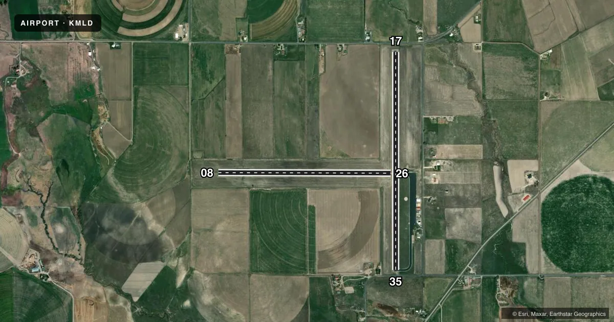
Airport sketch
Runways drawn to scale from FAA survey coordinates, rendered over satellite imagery. Not for navigation.
Approaches & charts
Services on the field
Fuel grades, oxygen, maintenance, ramp storage and lighting — as declared to the FAA by the airport operator.
Fuel & services
- Fuel
- 100LL
- Oxygen (bottled)
- Not available
- Oxygen (bulk)
- Not available
- Airframe repair
- Not available
- Power plant repair
- Not available
Ramp & ground
- Transient storage
- Tie-down
- Landing fee
- No fee published
- Lighting schedule
- SEE RMK
- Beacon schedule
- SS-SR
- Beacon
- White / Green (civil land)(WG)
- Wind indicator
- Lighted
- Segmented circle
- Yes
Fuel & FBOs
Cheapest 100LL and Jet A on the field and nearby. Always confirm with the FBO before taxi.
Airport notes
Surface conditions, obstructions, local procedures, lighting outages and other notes published with each FAA cycle.
General notes
- REFLECTORS ON TWY AND RAMP.
- FOR CD IF UNA TO CTC ON FSS FREQ, CTC SALT LAKE ARTCC AT 801-320-2568.
Lighting notes
- ACTVT MIRL RWY 17/35 - CTAF.
Fuel notes
- 100LLFOR FUEL CALL 208-221-9031. GAS PUMP IS CREDIT CARD OPR.
Runway surface & condition
- 17/35ASPH PAVEMENT IS 60 FT WIDE, 45 FT WIDE ASPH-TRTD SHOULDERS ON EACH SIDE OF PAVEMENT.
Approach & departure obstructions
- 17RWY 17 + 3 FT FENCE AT 100 FT & 180 FT ON CNTRLN; 15 FT ROAD AT 160 FT ON CNTRLN.
- 35+4 FT FENCE AT 60 FT ON CNTRLN; 15 FT ROAD AT 80 FT ON CNTRLN.
- 17PERM +20 FT SPRINKLER LINE.
Other notes
- ESTABD PRIOR TO 15 MAY 1959. RWY 08/26 NO OBJECTION.
- MANAGERROXANNE@HESSPUMICE.COM
VFR map & nearby airports
VFR sectional. Tap any ICAO chip to open that airport.
Key facts · KMLD
Answer card- ICAO
- KMLD
- Name
- MALAD CITY
- Location
- MALAD CITY, IDAHO
- Elevation
- 4,503 ft MSL
- Traffic pattern altitude
- 5,503 ft MSL (1,000 AGL)
- Control tower
- Non-towered (use CTAF)
- Total runways
- 2
- Longest runway
- 17/35 · 4,946 ft
- Published ILS approaches
- 0
- Published frequencies
- 1
- Magnetic variation
- 15°
- Current flight rules
- VFR
- Current wind
- 000° at 0 kt
- Favored runway now
- –
Malad City Airport sits in Malad City, Idaho. Field elevation is 4,503 ft MSL. The airport has two runways. The longest is 4,946 ft on runway 17/35. There is no control tower. CTAF is 122.9.
No ILS approaches are published here. Pattern altitude is not published, so use the current FAA Chart Supplement before you fly. The field is served by Malad City Airport on the field. It carries AVGAS 100LL. Call ahead if you need fuel or ramp details. The published remarks say the fuel pump is credit card operated.
Runway 17/35 is asphalt. It has medium intensity runway lights that activate on CTAF. The remarks also note a sprinkler line near the 17 end. There are fence and road obstructions near both ends of 17/35. Runway 08/26 is turf-dirt and is listed with no objection. The airport sits at higher elevation, so expect performance to matter on warm days. If you need clearance delivery help and cannot raise Flight Service, the Chart Supplement says to contact Salt Lake ARTCC. Check the current FAA Chart Supplement for any noise or curfew restrictions before flying into the field.