METAR & TAF KBMC
Current METAR
Observed 06:35Z
KBMC 120635Z AUTO 12001KT 10SM CLR 12/02 A3009 RMK AO2
- Wind
- 120° @ 1 kt
- Visibility
- 10 SM
- Temp / Dew
- 12°C / 2°C
- Altimeter
- 30.09 inHg
- Clouds
- CLR
- Density alt
- 4,674 ft
- Ceiling
- Unlimited
- Rules
- VFR
Airport info & contacts
Manager on record, flight service, ARTCC, attendance schedule and pattern altitude — published by the FAA and refreshed every 28 days.
Location
- From city
- 3 NM NW
- VFR sectional
- SALT LAKE CITY
- ARTCC
- ZLC · SALT LAKE CITY
- NOTAM facility
- CDC (NOTAM-D)
Airport manager
- Name
- TYLER PUGSLEY
- Phone
- 435-226-1437
- Address
- PO BOX 1005, BRIGHAM CITY UT 84302
Flight service · Hours
- FSS CDC
- CEDAR CITY1-800-WX-BRIEF
- Attendance
- MON-SAT · 0800-1800
Frequencies
Tap any row to copy the frequency to your clipboard.
Runways & pattern
Full pagePattern entry · RWY 17
LEFT TRAFFICRunway end performance
| End | TORA | TODA | ASDA | LDA | VGSI | Approach lights | Obstruction |
|---|---|---|---|---|---|---|---|
| 17 | — | — | — | — | PAPI 2-box left(3°) | — | — |
| 35 | — | — | — | — | PAPI 2-box left(3°) | — | — |
Declared distances in feet. TORA = takeoff run available, TODA = takeoff distance, ASDA = accelerate-stop, LDA = landing distance.
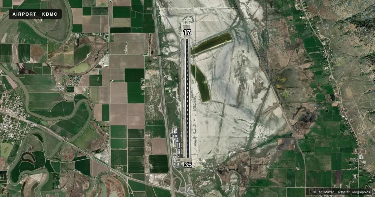
Airport sketch
Runways drawn to scale from FAA survey coordinates, rendered over satellite imagery. Not for navigation.
Approaches & charts
Services on the field
Fuel grades, oxygen, maintenance, ramp storage and lighting — as declared to the FAA by the airport operator.
Fuel & services
- Fuel
- 100LLA
- Oxygen (bottled)
- Not available
- Oxygen (bulk)
- Not available
- Airframe repair
- Major
- Power plant repair
- Major
- Other services
- AGRI,AVNCS,INSTR,RNTL,SURV
Ramp & ground
- Transient storage
- Tie-down
- Hangar
- Landing fee
- No fee published
- Customs
- Not available
- Lighting schedule
- SEE RMK
- Beacon schedule
- SS-SR
- Beacon
- White / Green (civil land)(WG)
- Wind indicator
- Lighted
- Segmented circle
- Yes
Fuel & FBOs
Cheapest 100LL and Jet A on the field and nearby. Always confirm with the FBO before taxi.
Airport notes
Surface conditions, obstructions, local procedures, lighting outages and other notes published with each FAA cycle.
General notes
- BIRDS INVOF APCH END OF RY 17.
- FOR CD CTC SALT LAKE CITY APCH AT 801-325-9670.
Lighting notes
- ACTVT REIL RWY 17 & 35; PAPI RWY 17 & 35; MIRL RWY 17/35 - CTAF.
Fuel notes
- 100LL24 HRS SELF SVC.
Approach & departure obstructions
- 17PAPI DOES NOT PROVD OBSTN CLNC BYD 2.5 NM FM THR.
Other notes
- MANAGERPUBLIC WORKS DIRECTOR/AMGR.
- MANAGEREMERGENCY NR 435-723-3800 (BOX ELDER COOMMUNICATION CENTER).
VFR map & nearby airports
VFR sectional. Tap any ICAO chip to open that airport.
Key facts · KBMC
Answer card- ICAO
- KBMC
- Name
- BRIGHAM CITY RGNL
- Location
- BRIGHAM CITY, UTAH
- Elevation
- 4,229.9 ft MSL
- Traffic pattern altitude
- 5,229.9 ft MSL (1,000 AGL)
- Control tower
- Non-towered (use CTAF)
- Total runways
- 1
- Longest runway
- 17/35 · 8,900 ft
- Published ILS approaches
- 0
- Published frequencies
- 5
- Magnetic variation
- 13°
- Current flight rules
- VFR
- Current wind
- 120° at 1 kt
- Favored runway now
- RWY 17
Brigham City Rgnl Airport (KBMC) sits in Brigham City, Utah. Field elevation is 4,229.9 ft MSL. The airport has one runway, 17/35, which is 8,900 ft long. There is no control tower. Pattern altitude is not published, so use standard 1,000 ft AGL for light piston aircraft unless the current Chart Supplement says otherwise.
No ILS approaches are published here. Runway 17 and 35 have runway end identifier lights. Medium intensity runway lights are available on 17/35 and are controlled by CTAF. PAPI is available for both runway ends. The published remarks also note birds near the approach end of runway 17. The PAPI does not provide obstruction clearance beyond 2.5 NM from the threshold. Treat that as a real planning item on final.
Two on-field FBOs are listed. Airmotive Service carries 100LL, JET A and JET A Prist. Mountain Air carries 100LL and JET A Prist. 100LL is available 24 hours by self-service. For clearance delivery, contact Salt Lake City Approach. First-time arrivals should expect a non-towered field with mountain-area performance considerations from the higher elevation. Verify current procedures with the airport operator or the current FAA Chart Supplement before departure.