METAR & TAF KMKL
Current METAR
Observed 15:53Z
KMKL 271553Z 28007KT 10SM CLR 31/24 A2992 RMK AO1 SLP124 T03060239 PNO
- Wind
- 280° @ 7 kt
- Visibility
- 10 SM
- Temp / Dew
- 31°C / 24°C
- Altimeter
- 29.92 inHg
- Clouds
- CLR
- Density alt
- 2,459 ft
- Ceiling
- Unlimited
- Rules
- VFR
Airport info & contacts
Manager on record, flight service, ARTCC, attendance schedule and pattern altitude — published by the FAA and refreshed every 28 days.
Location
- From city
- 4 NM W
- VFR sectional
- MEMPHIS
- ARTCC
- ZME · MEMPHIS
- NOTAM facility
- MKL (NOTAM-D)
Airport manager
- Name
- STEVE SMITH
- Phone
- 731-423-0995
- Address
- 308 GRADY MONTGOMERY DR, JACKSON TN 38301
Flight service · Hours
- FSS MKL
- JACKSON1-800-WX-BRIEF
- Attendance
- MON-FRI · 0600-2030
- SAT-SUN · 0700-1930
Frequencies
Tap any row to copy the frequency to your clipboard.
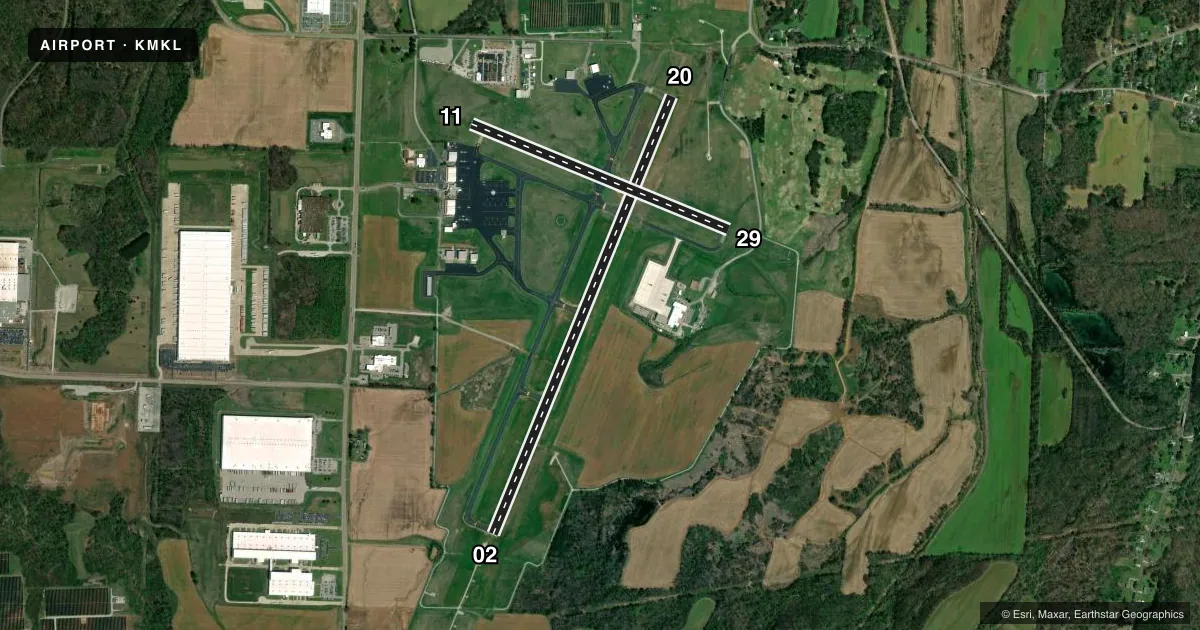
Runways & pattern
Full pagePattern entry · RWY 29
LEFT TRAFFIC| Runway | Heading (°M) | Length | Surface | Traffic |
|---|---|---|---|---|
| 02/20 | 21° / 201° | 6,007 ft | ASPH | Standard L |
| 11/29Favored | 111° / 291° | 3,539 ft | ASPH | Standard L |
Runway end performance
| End | TORA | TODA | ASDA | LDA | VGSI | Approach lights | Obstruction |
|---|---|---|---|---|---|---|---|
| 02 | — | — | — | — | PAPI 4-box left(3°) | MALSR | — |
| 20 | — | — | — | — | PAPI 4-box left(3°) | — | 40', tree, 1400' from thr, 600' R of cntrln, slope 30 |
| 11 | — | — | — | — | PAPI 4-box left(3°) | — | 66', tree, 1650' from thr, 50' R of cntrln, slope 21 |
| 29 | — | — | — | — | PAPI 4-box left(3°) | — | 45', tree, 1100' from thr, 320' R of cntrln, slope 20 |
Declared distances in feet. TORA = takeoff run available, TODA = takeoff distance, ASDA = accelerate-stop, LDA = landing distance.
Airport sketch
Runways drawn to scale from FAA survey coordinates, rendered over satellite imagery. Not for navigation.
Approaches & charts
ILS · 1
Services on the field
Fuel grades, oxygen, maintenance, ramp storage and lighting — as declared to the FAA by the airport operator.
Fuel & services
- Fuel
- 100LLA
- Airframe repair
- Major
- Power plant repair
- Major
- Other services
- AFRT,AVNCS,CHTR,INSTR,RNTL,SALES
Ramp & ground
- Transient storage
- Tie-down
- Hangar
- Landing fee
- No fee published
- Customs
- Not available
- Lighting schedule
- SEE RMK
- Beacon schedule
- SS-SR
- Beacon
- White / Green (civil land)(WG)
- Wind indicator
- Lighted
- Segmented circle
- Yes
Fuel & FBOs
Cheapest 100LL and Jet A on the field and nearby. Always confirm with the FBO before taxi.
Airport notes
Surface conditions, obstructions, local procedures, lighting outages and other notes published with each FAA cycle.
General notes
- MILITARY: ARNG: BASE OPS 1200-2130Z++ MON-FRI. CLSD EVERY OTHER MONDAY, FAC CLSD SAT, SUN & HOL. PPR C629-332-9658. ARNG OPS 49.95.
- PPR FOR GND ACCESS TO FLD 2130-0600 - 731-394-1755.
- ACR OPS MORE THAN 9 PAX SEATS NA IN EXCESS OF 15 MIN BFR OR AFT SKED ARR OR DEP TIMES WO PRIOR AVBLTY COORD WITH AMGR & CFM.
- FOR CD CTC MEMPHIS ARTCC AT 901-368-8453/8449.
Lighting notes
- WHEN ATCT CLSD ACTVT MALSR RWY 02; HIRL RWY 02/20, MIRL RWY 11/29 - CTAF. PAPI RWY 02 & 20 OPR CONSLY.
Runway surface & condition
- 02/20PCR VALUE: 1230/F/C/X/T
Other notes
- CLSD TO UNSKED ACR OPS MORE THAN 30 PAX SEATS EXC 24 HR PPR - AMGR.
- 1AFT HR - 731-394-1755.
- 02/20FADED.
- 11/29FADED.
- 02/20GROOVED 55 FT EACH SIDE OF CNTRLN.
VFR map & nearby airports
VFR sectional. Tap any ICAO chip to open that airport.
Key facts · KMKL
Answer card- ICAO
- KMKL
- Name
- JACKSON RGNL
- Location
- JACKSON, TENNESSEE
- Elevation
- 434.8 ft MSL
- Traffic pattern altitude
- 1,434.8 ft MSL (1,000 AGL)
- Control tower
- Towered · 0700-1900
- Total runways
- 2
- Longest runway
- 02/20 · 6,007 ft
- Published ILS approaches
- 1
- Published frequencies
- 5
- Magnetic variation
- 1°
- Current flight rules
- VFR
- Current wind
- 280° at 7 kt
- Favored runway now
- RWY 29
Jackson Rgnl is in Jackson, Tennessee. Field elevation is 434.8 ft MSL. The airport has two asphalt runways. The longest is 6,007 ft on runway 02/20. The tower is open from 0700 to 1900. One ILS is published for runway 02. Pattern altitude is not published. For light piston traffic, use 1,000 ft AGL as the standard pattern reference unless local procedures say otherwise.
The on-field FBO is Jackson Regional Airport. It carries 100LL, Jet A and Jet A Prist. Call (731) 423-0191 for current service details. This field also has several operational notes that matter on a first visit. Base operations run from 0630 to 1600 Monday through Friday. Prior permission is required by calling 731-425-5600. Ground access from 2130 to 0600 also needs prior permission by calling 731-394-1755.
Runway 02/20 is grooved 55 feet each side of centerline. Runway 11/29 is faded. Runway 02/20 is also faded. When the tower is closed, use CTAF for lighting activation. The published notes say runway 02 has medium intensity approach lights with runway alignment indicator lights. Runways 02 and 20 have high intensity runway lights. Runway 11/29 has medium intensity runway lights. Clearance delivery goes through Memphis ARTCC. This is the kind of airport where it pays to brief the published remarks before taxi.