METAR & TAF KJST
Current METAR
Observed 17:54Z
KJST 271754Z AUTO 28009KT 10SM FEW026 FEW033 24/17 A2994 RMK AO2 SLP123 T02440172 10244 20183 58007
- Wind
- 280° @ 9 kt
- Visibility
- 10 SM
- Temp / Dew
- 24°C / 17°C
- Altimeter
- 29.94 inHg
- Clouds
- FEW
- Density alt
- 3,888 ft
- Ceiling
- Unlimited
- Rules
- VFR
Airport info & contacts
Manager on record, flight service, ARTCC, attendance schedule and pattern altitude — published by the FAA and refreshed every 28 days.
Location
- From city
- 3 NM NE
- VFR sectional
- DETROIT
- ARTCC
- ZOB · CLEVELAND
- NOTAM facility
- JST (NOTAM-D)
Airport manager
- Name
- CORY CREE
- Phone
- 814-536-0002
- Address
- 479 ARPT ROAD, JOHNSTOWN PA 15904
Flight service · Hours
- FSS AOO
- ALTOONA1-800-WX-BRIEF
- Attendance
- 0700-2300
Frequencies
Tap any row to copy the frequency to your clipboard.
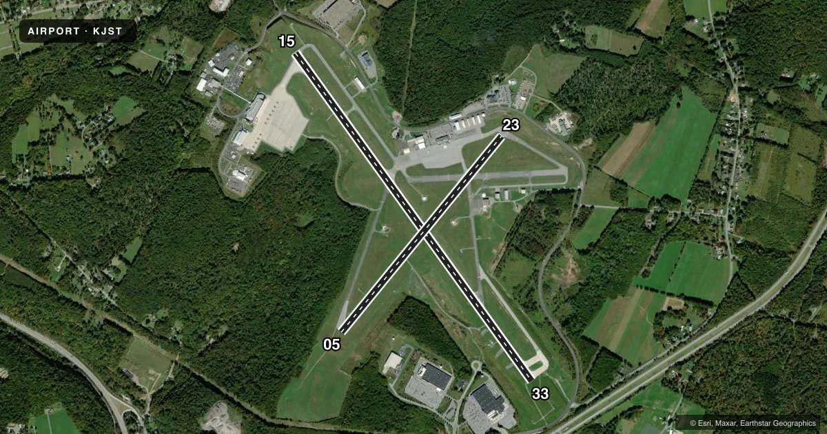
Runways & pattern
Full pagePattern entry · RWY 33
LEFT TRAFFIC| Runway | Heading (°M) | Length | Surface | Traffic |
|---|---|---|---|---|
| 15/33Favored | 134° / 314° | 7,004 ft | CONC | Standard L |
| 05/23 | 29° / 209° | 4,387 ft | ASPH | Standard L |
Runway end performance
| End | TORA | TODA | ASDA | LDA | VGSI | Approach lights | Obstruction |
|---|---|---|---|---|---|---|---|
| 15 | 7,004' | 7,004' | 6,698' | 6,698' | VASI 4-box left(3°) | — | 36', trees, 480' from thr, 394' R of cntrln, slope 7 |
| 33 | 7,004' | 7,004' | 6,484' | 6,484' | PAPI 4-box right(3°) | MALSR | 17', trees, 928' from thr, 436' R of cntrln, slope 42 |
| 05 | 4,387' | 4,387' | 4,387' | 4,387' | PAPI 4-box left(3°) | — | 26', trees, 261' from thr, 402' R of cntrln, slope 2 |
| 23 | 4,387' | 4,387' | 4,387' | 4,387' | VASI 4-box left(3°) | — | 46', bldg, 746' from thr, 576' R of cntrln, slope 11 |
Declared distances in feet. TORA = takeoff run available, TODA = takeoff distance, ASDA = accelerate-stop, LDA = landing distance.
Airport sketch
Runways drawn to scale from FAA survey coordinates, rendered over satellite imagery. Not for navigation.
Approaches & charts
ILS · 1
Services on the field
Fuel grades, oxygen, maintenance, ramp storage and lighting — as declared to the FAA by the airport operator.
Fuel & services
- Fuel
- 100LLAA+
- Airframe repair
- Major
- Power plant repair
- Major
- Other services
- AFRT,CHTR,INSTR,RNTL,SURV
Ramp & ground
- Transient storage
- Tie-down
- Hangar
- Landing fee
- Yes
- Lighting schedule
- SEE RMK
- Beacon schedule
- SS-SR
- Beacon
- White / Green (civil land)(WG)
- Wind indicator
- Lighted
- Segmented circle
- No
Fuel & FBOs
Cheapest 100LL and Jet A on the field and nearby. Always confirm with the FBO before taxi.
Airport notes
Surface conditions, obstructions, local procedures, lighting outages and other notes published with each FAA cycle.
General notes
- ARNG: RSTD PPR 24 HR, CALL DUR NML DUTY HOURS 1300-2130Z++ EXC WKEND AND HOL. CTC OPS C814-532-7720. ALL TFC TO ARNG MILITARY RAMP CTC KEYSTONE OPS: 138.55, 241.35, 46.75, RAMP DECONFLICTION 46.75.
- DEER & BIRDS ON & INVOF ARPT.
- FOR CD CTC JOHNSTOWN APCH AT 814-532-5960, WHEN APCH CLSD CTC CLEVELAND ARTCC AT 440-774-0213.
- TWY B BTN RWY 05/23 AND TWY B2 RSTRD TO ACFT WITH WINGSPAN 78 FT OR LESS.
Lighting notes
- WHEN TWR CLSD ACTVT MALSR RWY 33; PAPI RWY 33; HIRL RWY 15/33, MIRL RWY 5/23 AND ALL TWY LGTS - CTAF. PAPI RWY 05 UNAVBL WHEN ATCT CLSD.
Runway surface & condition
- 05/232S-110.
- 05/23PCR VALUE: 240/F/D/X/T
- 15/33PCR VALUE: 630/R/B/W/T
Other notes
- 48 HR PPR FOR UNSKED ACR OPS WITH MORE THAN 30 PAX SEATS; CALL AMGR 814-536-0002.
- UNICOM FREQ 122.950 AVBL FOR GND SVCS ONLY.
VFR map & nearby airports
VFR sectional. Tap any ICAO chip to open that airport.
Key facts · KJST
Answer card- ICAO
- KJST
- Name
- JOHN MURTHA JOHNSTOWN/CAMBRIA COUNTY
- Location
- JOHNSTOWN, PENNSYLVANIA
- Elevation
- 2,284.2 ft MSL
- Traffic pattern altitude
- 3,284.2 ft MSL (1,000 AGL)
- Control tower
- Towered · 0700-2300
- Total runways
- 2
- Longest runway
- 15/33 · 7,004 ft
- Published ILS approaches
- 1
- Published frequencies
- 10
- Magnetic variation
- 10°
- Current flight rules
- VFR
- Current wind
- 280° at 9 kt
- Favored runway now
- RWY 33
John Murtha Johnstown/Cambria County Airport is in Johnstown, Pennsylvania. Field elevation is 2,284.2 ft MSL. The airport has two runways. The longest is runway 15/33 at 7,004 ft. The tower is open 0700-2300. An ILS is available for runway 33.
Pattern altitude is not published in the facts. For light piston traffic, use the standard 1,000 ft AGL unless the current Chart Supplement says otherwise. Nulton Aviation Services is on the field. It carries 100LL, Jet A and Jet A Prist. Call the FBO directly for current service details.
A few published remarks matter here. Clearance delivery is handled through Johnstown Approach when it is open. When the tower is closed, runway 33 lighting and taxiway lights can be activated on CTAF. The PAPI for runway 05 is not available when the tower is closed. Deer and birds are reported on and near the airport. Taxiway B between runway 05/23 and taxiway B2 is limited to aircraft with wingspan 78 ft or less. Pilots should also note the airport sits at a fairly high field elevation. Performance planning matters, especially on warm days.