METAR & TAF KGRB
Current METAR
Observed 13:33Z
KGRB 271333Z 16005KT 8SM OVC009 26/23 A2974 RMK AO2 T02610233
- Wind
- 160° @ 5 kt
- Visibility
- 8 SM
- Temp / Dew
- 26°C / 23°C
- Altimeter
- 29.74 inHg
- Clouds
- OVC
- Density alt
- 2,405 ft
- Ceiling
- 900 ft AGL
- Rules
- IFR
Airport info & contacts
Manager on record, flight service, ARTCC, attendance schedule and pattern altitude — published by the FAA and refreshed every 28 days.
Location
- From city
- 7 NM SW
- VFR sectional
- GREEN BAY
- ARTCC
- ZMP · MINNEAPOLIS
- NOTAM facility
- GRB (NOTAM-D)
Airport manager
- Name
- MARTY PIETTE
- Phone
- 920-498-4800
- Address
- 2077 AIRPORT DRIVE, GREEN BAY WI 54313-5596
Flight service · Hours
- FSS GRB
- GREEN BAY1-800-WX-BRIEF
- Attendance
- 0500-2200
Frequencies
Tap any row to copy the frequency to your clipboard.
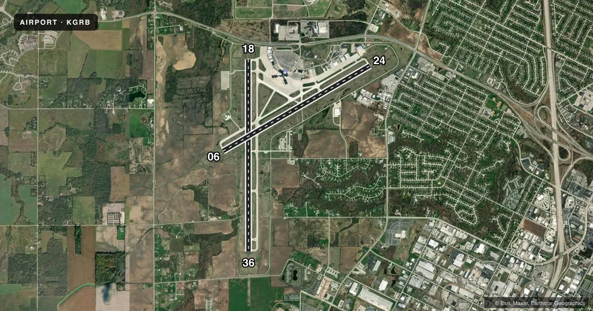
Runways & pattern
Full pagePattern entry · RWY 18
RIGHT TRAFFIC| Runway | Heading (°M) | Length | Surface | Traffic |
|---|---|---|---|---|
| 18/36Favored | 178° / 358° | 8,700 ft | CONC | 18 R |
| 06/24 | 58° / 238° | 7,700 ft | CONC | Standard L |
Runway end performance
| End | TORA | TODA | ASDA | LDA | VGSI | Approach lights | Obstruction |
|---|---|---|---|---|---|---|---|
| 18 | 8,700' | 8,700' | 8,700' | 8,201' | PAPI 4-box right(3°) | — | 12', road, 580' from thr, 540' R of cntrln, slope 31 |
| 36 | 8,201' | 8,201' | 8,201' | 8,201' | PAPI 4-box left(3°) | MALSR | — |
| 06 | 7,699' | 7,699' | 7,699' | 7,699' | PAPI 4-box left(3°) | MALSR | — |
| 24 | 7,699' | 7,699' | 7,699' | 7,699' | PAPI 4-box left(3°) | — | — |
Declared distances in feet. TORA = takeoff run available, TODA = takeoff distance, ASDA = accelerate-stop, LDA = landing distance.
Airport sketch
Runways drawn to scale from FAA survey coordinates, rendered over satellite imagery. Not for navigation.
Approaches & charts
ILS · 2
Services on the field
Fuel grades, oxygen, maintenance, ramp storage and lighting — as declared to the FAA by the airport operator.
Fuel & services
- Fuel
- 100LLA
- Oxygen (bottled)
- High pressure
- Oxygen (bulk)
- High pressure
- Airframe repair
- Major
- Power plant repair
- Major
Ramp & ground
- Transient storage
- Tie-down
- Hangar
- Customs
- Not available
- Lighting schedule
- SEE RMK
- Beacon schedule
- SS-SR
- Beacon
- White / Green (civil land)(WG)
- Wind indicator
- Lighted
- Segmented circle
- No
Fuel & FBOs
Cheapest 100LL and Jet A on the field and nearby. Always confirm with the FBO before taxi.
Airport notes
Surface conditions, obstructions, local procedures, lighting outages and other notes published with each FAA cycle.
General notes
- AVOID NOISE SENSITIVE AREAS N & E OF ARPT 2400-0600.
- TWY C NOT AVBL FOR ACR MORE THAN 30 PAX SEATS.
- TWY D WBND NO TURN ONTO TWY J.
- TWY J SWB NO TURN ONTO NBND TWY M.
- TWY M SBND NO TURN ONTO TWY J.
- TWY J SWB NO TURN ONTO EB TWY D.
- WHEN ATC CLSD FOR CD IF UNA TO CTC ON FSS FREQ, CTC MINNEAPOLIS ARTCC AT 651-463-5588.
- BIRDS ON & INVOF ARPT.
- TWY D BTN TWY H & RWY 24 APCH END CLSD TO WINGSPAN GTR THAN 118 FT.
Lighting notes
- ACTVT MALSR RWY 06 & 36; REIL RWY 18; HIRL RWY 06/24 & 18/36 - CTAF. PAPI RWY 06, 18, 24 & 36 OPR CONSLY. WHEN ATCT CLSD PREFERRED RWY PRESET ON LOW OR MED INTST; INCR INTST - CTAF.
Runway surface & condition
- 06/24PCR VALUE: 520/R/B/W/T
- 18/36PCR VALUE: 520/R/B/W/T
Approach & departure obstructions
- 18APCH RATIO 50:1 TO THE DTHR.
VFR map & nearby airports
VFR sectional. Tap any ICAO chip to open that airport.
Key facts · KGRB
Answer card- ICAO
- KGRB
- Name
- GREEN BAY/AUSTIN STRAUBEL INTL
- Location
- GREEN BAY, WISCONSIN
- Elevation
- 695.1 ft MSL
- Traffic pattern altitude
- 1,695.1 ft MSL (1,000 AGL)
- Control tower
- Towered · 0530-2330
- Total runways
- 2
- Longest runway
- 18/36 · 8,700 ft
- Published ILS approaches
- 2
- Published frequencies
- 13
- Magnetic variation
- 2°
- Current flight rules
- IFR
- Current wind
- 160° at 5 kt
- Favored runway now
- RWY 18
Green Bay/Austin Straubel Intl sits in Green Bay, Wisconsin. The field elevation is 695.1 ft MSL. KGRB has two concrete runways. The longest is 8,700 ft on 18/36. The other runway is 06/24 at 7,700 ft. The tower is open daily from 0530 to 2330. Two ILS approaches are published for runway ends 06 and 36.
Pattern altitude is not published in the facts. Use the standard 1,000 ft AGL for light piston traffic unless ATC or the current Chart Supplement says otherwise. The airport is in a busy Class C environment. Expect normal tower and approach coordination on arrival and departure.
Jet Air Group is on the field. Avlight Green Bay is also on the field. Both carry 100LL, Jet A and Jet A Prist. The published remarks also note birds in the area. Noise-sensitive areas north and east of the airport should be avoided from 2400 to 0600. There is also a lighting note. Some approach lighting components are reported as malfunctioning. The runway lights and PAPI operate with CTAF procedures when the tower is closed. If you are planning a night arrival or a low-weather approach, verify the current status with ATC or the airport operator before you go.