METAR & TAF KGEV
Current METAR
Observed 12:55Z
KGEV 271255Z AUTO 00000KT 10SM SCT020 BKN028 21/19 A3005 RMK AO2 T02070193
- Wind
- 000° @ 0 kt
- Visibility
- 10 SM
- Temp / Dew
- 21°C / 19°C
- Altimeter
- 30.05 inHg
- Clouds
- BKN
- Density alt
- 4,499 ft
- Ceiling
- 2,800 ft AGL
- Rules
- MVFR
Airport info & contacts
Manager on record, flight service, ARTCC, attendance schedule and pattern altitude — published by the FAA and refreshed every 28 days.
Location
- From city
- 3 NM E
- VFR sectional
- CINCINNATI
- ARTCC
- ZTL · ATLANTA
- NOTAM facility
- GEV (NOTAM-D)
Airport manager
- Name
- ERIC PAYNE
- Phone
- 336-982-5144
- Address
- 639 AIRPORT ROAD, JEFFERSON NC 28640
Flight service · Hours
- FSS RDU
- RALEIGH1-800-WX-BRIEF
- Attendance
- 0830-1630
Frequencies
Tap any row to copy the frequency to your clipboard.
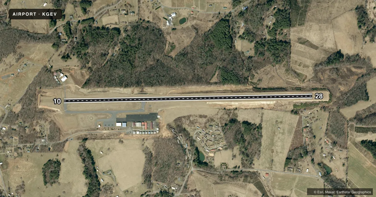
Runways & pattern
Full pagePattern entry · RWY 10
LEFT TRAFFICRunway end performance
| End | TORA | TODA | ASDA | LDA | VGSI | Approach lights | Obstruction |
|---|---|---|---|---|---|---|---|
| 10 | — | — | — | — | — | — | 20', trees, 583' from thr, 87' R of cntrln, slope 19 |
| 28 | — | — | — | — | PAPI 2-box left(3°) | — | 7', brush, 257' from thr, 101' R of cntrln, slope 8 |
Declared distances in feet. TORA = takeoff run available, TODA = takeoff distance, ASDA = accelerate-stop, LDA = landing distance.
Airport sketch
Runways drawn to scale from FAA survey coordinates, rendered over satellite imagery. Not for navigation.
Approaches & charts
ILS · 1
Services on the field
Fuel grades, oxygen, maintenance, ramp storage and lighting — as declared to the FAA by the airport operator.
Fuel & services
- Fuel
- 100LLA1+
- Oxygen (bottled)
- Not available
- Oxygen (bulk)
- Not available
- Airframe repair
- Major
- Power plant repair
- Major
- Other services
- AGRI,INSTR,RNTL
Ramp & ground
- Transient storage
- Tie-down
- Landing fee
- No fee published
- Lighting schedule
- SEE RMK
- Beacon schedule
- SS-SR
- Beacon
- White / Green (civil land)(WG)
- Wind indicator
- Lighted
- Segmented circle
- Yes
Fuel & FBOs
Cheapest 100LL and Jet A on the field and nearby. Always confirm with the FBO before taxi.
Airport notes
Surface conditions, obstructions, local procedures, lighting outages and other notes published with each FAA cycle.
General notes
- RISING TRRN ALL QUADS.
- DEER INVOF ARPT.
- RWYS 10 & 28 SAFETY AREAS HAVE 100 FT DROP-OFFS 270 FT FM THR.
- RWY 28 HAS AN UPHILL GRADE.
- OCNL CROPS AND FARMING EQPT ADJ TO RWY.
- RWY 28 HAS 100 FT DROP-OFFS 90 FT LEFT AND RIGHT OF CNTRLN.
- FOR CD CTC ATLANTA ARTCC AT 770-210-7692.
- COLD TEMPERATURE AIRPORT. ALTITUDE CORRECTION REQUIRED AT OR BELOW -16C.
Lighting notes
- ACTVT REIL RWY 28; PAPI RWY 28; MIRL RWY 10/28 - CTAF.
Fuel notes
- 100LL24 HR JET A FUEL AVBL WITH CREDIT CARD.
Approach & departure obstructions
- 28DUE TO 7 FT BRUSH 0-50 FT FM THR OFFSET 121 FT RIGHT OF CNTRLN AND 7 FT BRUSH 0-25 FT FM THR OFFSET 168 FT LEFT OF CNTRLN.
Other notes
- 1UNATNDD THANKSGIVING AND CHRISTMAS.
- 1FOR SVC AFT HRS CALL 336-877-1102.
VFR map & nearby airports
VFR sectional. Tap any ICAO chip to open that airport.
Key facts · KGEV
Answer card- ICAO
- KGEV
- Name
- ASHE COUNTY
- Location
- JEFFERSON, NORTH CAROLINA
- Elevation
- 3,177.5 ft MSL
- Traffic pattern altitude
- 4,177.5 ft MSL (1,000 AGL)
- Control tower
- Non-towered (use CTAF)
- Total runways
- 1
- Longest runway
- 10/28 · 5,002 ft
- Published ILS approaches
- 1
- Published frequencies
- 2
- Magnetic variation
- 7°
- Current flight rules
- MVFR
- Current wind
- 000° at 0 kt
- Favored runway now
- –
Ashe County Airport sits in Jefferson, North Carolina. The field elevation is 3,177.5 ft MSL. It has one runway, 10/28, which is 5,002 ft long. There is no control tower. CTAF and UNICOM are both 122.8. The airport has one ILS approach to runway 28. Pattern altitude is not published in the facts, so use the standard 1,000 ft AGL for light piston traffic unless the current FAA Chart Supplement says otherwise.
This is a mountain airport. Rising terrain is in all quadrants. Runway 28 has 100 foot drop-offs on both sides of the centerline. The runway also has end identifier lights and a PAPI. Medium intensity runway lights are installed on 10 and 28. All lighting is controlled on CTAF. The published remarks also call out deer in the area. There are trees near the runway 10 threshold. Brush sits near the runway 28 threshold. Occasional crops and farm equipment can be adjacent to the runway.
Ashe County Airport has one on-field FBO, Ashe County Airport. It carries 100LL and Jet A Prist. Jet A is listed as available 24 hours with credit card. For service after hours, call the number in the Chart Supplement or the airport directly. This field is unattended on Thanksgiving and Christmas. Cold weather performance matters here. Altitude correction is required at or below minus 16 degrees Celsius.