METAR & TAF KFMY
Current METAR
Observed 19:53Z
KFMY 271953Z 32016G21KT 10SM FEW040 32/23 A2991 RMK AO2 LTG DSNT NE SLP129 T03170228
- Wind
- 320° @ 16G21 kt
- Visibility
- 10 SM
- Temp / Dew
- 32°C / 23°C
- Altimeter
- 29.91 inHg
- Clouds
- FEW
- Density alt
- 2,073 ft
- Ceiling
- Unlimited
- Rules
- VFR
Airport info & contacts
Manager on record, flight service, ARTCC, attendance schedule and pattern altitude — published by the FAA and refreshed every 28 days.
Location
- From city
- 3 NM S
- VFR sectional
- MIAMI
- ARTCC
- ZMA · MIAMI
- NOTAM facility
- FMY (NOTAM-D)
Airport manager
- Name
- SCOTT SHEETS
- Phone
- 239-590-6601
- Address
- 5200 CAPTAIN CHANNING PAGE DRIVE, FORT MYERS FL 33907
Flight service · Hours
- FSS MIA
- MIAMI1-800-WX-BRIEF
- Attendance
- 0700-2000
Frequencies
Tap any row to copy the frequency to your clipboard.
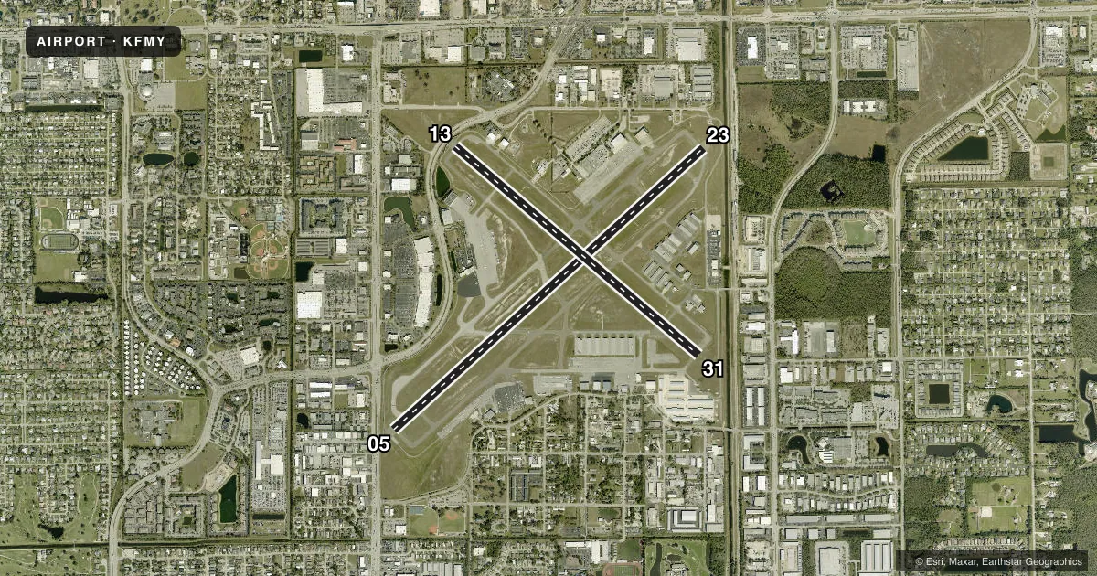
Runways & pattern
Full pagePattern entry · RWY 31
LEFT TRAFFIC| Runway | Heading (°M) | Length | Surface | Traffic |
|---|---|---|---|---|
| 05/23 | 45° / 225° | 6,406 ft | ASPH | Standard L |
| 13/31Favored | 127° / 307° | 4,910 ft | ASPH | Standard L |
Runway end performance
| End | TORA | TODA | ASDA | LDA | VGSI | Approach lights | Obstruction |
|---|---|---|---|---|---|---|---|
| 05 | 6,406' | 6,406' | 6,005' | 5,545' | PAPI 4-box left(3°) | — | 15', road, 200' from thr, 125' R of cntrln, slope 1 |
| 23 | 6,406' | 6,406' | 5,946' | 5,545' | PAPI 4-box left(3°) | — | 23', rr, 180' from thr, 500' R of cntrln, slope 0 |
| 13 | 4,910' | 4,910' | 4,910' | 4,296' | PAPI 4-box left(3°) | — | 15', road, 200' from thr, 0' R of cntrln, slope 1 |
| 31 | 4,705' | 4,910' | 4,705' | 4,705' | PAPI 4-box right(3°) | — | 24', rr, 545' from thr, 250' R of cntrln, slope 14 |
Declared distances in feet. TORA = takeoff run available, TODA = takeoff distance, ASDA = accelerate-stop, LDA = landing distance.
Airport sketch
Runways drawn to scale from FAA survey coordinates, rendered over satellite imagery. Not for navigation.
Approaches & charts
ILS · 1
Services on the field
Fuel grades, oxygen, maintenance, ramp storage and lighting — as declared to the FAA by the airport operator.
Fuel & services
- Fuel
- 100LLA
- Oxygen (bottled)
- HIGH/LOW
- Oxygen (bulk)
- HIGH/LOW
- Airframe repair
- Major
- Power plant repair
- Major
- Other services
- AMB,AVNCS,CHTR,INSTR,RNTL,SALES
Ramp & ground
- Transient storage
- Tie-down
- Hangar
- Landing fee
- Yes
- Customs
- Not available
- Lighting schedule
- SEE RMK
- Beacon schedule
- SS-SR
- Beacon
- White / Green (civil land)(WG)
- Wind indicator
- Lighted
Fuel & FBOs
Cheapest 100LL and Jet A on the field and nearby. Always confirm with the FBO before taxi.
Airport notes
Surface conditions, obstructions, local procedures, lighting outages and other notes published with each FAA cycle.
General notes
- HIGH DENSITY BIRD POPULATION WITHIN THE ARPT BOUNDARIES.
- BRIGHTLY LGTD BALL FIELD 1500 FT SE OF AER 05.
- NOISE SENSITIVE AIRPORT - VOLUNTARY RESTRICTION FOR LARGE AIRCRAFT AND JET AIRCRAFT CONDUCTING MULTIPLE APPROACHES AND/OR CLOSED TRAFFIC.
- TWY 'B' SE OF TWY 'A' IS NON-MOVEMENT AREA NOT VSB FM ATCT.
- PAEW ADJ TO RYS & TWYS DURING DALGT HRS.
- NO SKED COML PSGN OPNS. FOR INFO CALL AMGR 239-590-6600.
- TAXILANE D FROM D-3 TO TWY A IS A NON-MOVEMENT AREA.
- ACFT ON ALL RAMPS CTC GC PRIOR TO TAXI.
- FOR CD IF UNA TO CTC ON FSS FREQ, CTC FT MYERS APCH AT 239-416-1026, WHEN APCH CLSD CTC MIAMI ARTCC AT 305-716-1731.
- TWY E2 BTN TWY E AND WEST RAMP CLSD TO ACFT WINGSPAN MORE THAN 79 FT.
- WEST RAMP IS DSGND AS THE FBO RAMP. ALL OTR RAMPS ARE DSGND AS GA TENANT RAMPS.
- SELF SERVE FUEL RAMP CLSD TO ACFT WINGSPAN MORE THAN 49 FT.
- 24 HR ADVN NOTICE OR IMT REPORTING UPON LDG FOR ACFT EQUIPPED WITH WEATHER MODIFICATION OR GEOENGINEERING EQUIP CTC ARPT OPS 239-590-4810.
Lighting notes
- WHEN ATCT CLSD, ACTVT REIL RWY 5, 13, 23, & 31; PAPI RWY 5, 13, 23, & 31; MIRL RWY 5/23 & 13/31 - CTAF.
Approach & departure obstructions
- 05RWY 05 HAS 6 FT FENCE & 15 FT ROAD 185 FT FM RWY END.
- 1315 FT BLAST FENCE & ROAD END OF RY.
- 23RWY 23 HAS 23 FT RR 180 FT FM END OF RWY, 500 FT LEFT OF CNTRLN.
- 05RWY 05 APCH SLOPE TO DSPLCD THR 34:1 DUE TO 24 FT BLDG 345 FM END OF RWY 255 FT LEFT OF CNTRLN.
- 13RWY 13 APCH SLOPE 47:1 TO DSPLCD THR.
- 23RY 23 APCH SLOPE 25:1 TO DSPLCD THLD.
- 31RWY 31 APCH SLOPE 34:1 TO AER.
Other notes
- AIR TO FBO COMM AVBL ON 130.55.
- MANAGERAIRPORT PHYSICAL ADDRESS: 5200 CAPT. CHANNING PAGE DRIVE.
- OWNERCTC PERSON: STEVE HENNIGAN 239-590-4700
VFR map & nearby airports
VFR sectional. Tap any ICAO chip to open that airport.
Key facts · KFMY
Answer card- ICAO
- KFMY
- Name
- PAGE FLD
- Location
- FORT MYERS, FLORIDA
- Elevation
- 17 ft MSL
- Traffic pattern altitude
- 1,017 ft MSL (1,000 AGL)
- Control tower
- Towered · 0700-2200
- Total runways
- 2
- Longest runway
- 05/23 · 6,406 ft
- Published ILS approaches
- 1
- Published frequencies
- 11
- Magnetic variation
- 3°
- Current flight rules
- VFR
- Current wind
- 320° at 16 kt
- Favored runway now
- RWY 31
Page Field sits in Fort Myers, Florida. The field elevation is 17 ft MSL. It has 2 asphalt runways. The longest is 6,406 ft on runway 05/23. The tower is open 0700-2200. One ILS approach is published for runway 05. Pattern altitude is not published, so use the standard 1,000 ft AGL for light piston traffic unless ATC says otherwise.
Base Operations is on the field. It carries 100LL, Jet A and Jet A Prist. Air-to-FBO communication is available on 130.55. This is a noise sensitive airport with voluntary restrictions for large aircraft and jet aircraft doing multiple approaches or closed traffic. That matters here if you are planning pattern work.
Runway 23 has a railroad 180 ft from the end of the runway. It sits 500 ft left of centerline. The runway 23 approach slope is 25 to 1 to the displaced threshold. There is also a brightly lighted ball field 1,500 ft southeast of the airport near runway 05. When the tower is closed, use CTAF for runway end identifier lights, PAPI and medium intensity runway lights on both runways. If you need clearance delivery help, Fort Myers Approach can assist when Flight Service is not available. Check the current FAA Chart Supplement for any current noise or operational notes before you go.