METAR & TAF KEAT
Current METAR
Observed 12:55Z
KEAT 221255Z 27006KT 10SM CLR 22/11 A2994
- Wind
- 270° @ 6 kt
- Visibility
- 10 SM
- Temp / Dew
- 22°C / 11°C
- Altimeter
- 29.94 inHg
- Clouds
- CLR
- Density alt
- 2,364 ft
- Ceiling
- Unlimited
- Rules
- VFR
Airport info & contacts
Manager on record, flight service, ARTCC, attendance schedule and pattern altitude — published by the FAA and refreshed every 28 days.
Location
- From city
- 4 NM E
- VFR sectional
- SEATTLE
- ARTCC
- ZSE · SEATTLE
- NOTAM facility
- EAT (NOTAM-D)
Airport manager
- Name
- TRENT MOYERS
- Phone
- 509-884-4700
- Address
- ONE CAMPBELL PARKWAY, EAST WENATCHEE WA 98802
Flight service · Hours
- FSS SEA
- SEATTLE1-800-WX-BRIEF
- Attendance
- 0800-1800
Frequencies
Tap any row to copy the frequency to your clipboard.
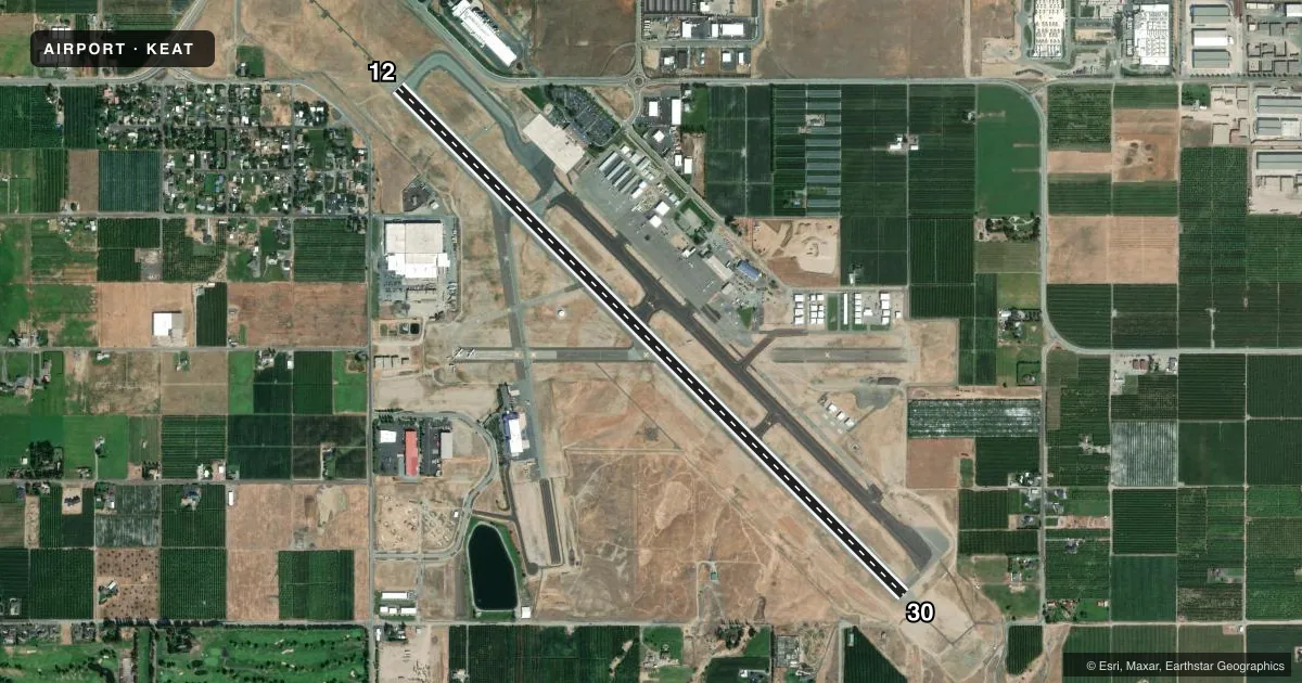
Runways & pattern
Full pagePattern entry · RWY 30
LEFT TRAFFICRunway end performance
| End | TORA | TODA | ASDA | LDA | VGSI | Approach lights | Obstruction |
|---|---|---|---|---|---|---|---|
| 12 | 7,000' | 7,000' | 7,000' | 7,000' | PAPI 4-box left(3.6°) | MALSR | 18', road, 500' from thr, 280' R of cntrln, slope 16 |
| 30 | 7,000' | 7,000' | 7,000' | 7,000' | PAPI 4-box left(3.6°) | — | — |
Declared distances in feet. TORA = takeoff run available, TODA = takeoff distance, ASDA = accelerate-stop, LDA = landing distance.
Airport sketch
Runways drawn to scale from FAA survey coordinates, rendered over satellite imagery. Not for navigation.
Approaches & charts
ILS · 1
Services on the field
Fuel grades, oxygen, maintenance, ramp storage and lighting — as declared to the FAA by the airport operator.
Fuel & services
- Fuel
- 100LLA
- Oxygen (bottled)
- Not available
- Oxygen (bulk)
- HIGH/LOW
- Airframe repair
- Major
- Power plant repair
- Major
- Other services
- AFRT,AMB,GLD,INSTR,RNTL,TOW
Ramp & ground
- Transient storage
- Tie-down
- Landing fee
- Yes
- Customs
- Not available
- Lighting schedule
- SEE RMK
- Beacon schedule
- SS-SR
- Beacon
- White / Green (civil land)(WG)
- Wind indicator
- Lighted
- Segmented circle
- Yes
Fuel & FBOs
Cheapest 100LL and Jet A on the field and nearby. Always confirm with the FBO before taxi.
Airport notes
Surface conditions, obstructions, local procedures, lighting outages and other notes published with each FAA cycle.
General notes
- GLIDER ACTIVITY FROM MAR-NOV.
- COLD TEMPERATURE AIRPORT. ALTITUDE CORRECTION REQUIRED AT OR BELOW -6C.
- UAS ACTVTY 1.56 NM E OF THE EAT VOR, 400 FT & BLW DURG DALGT HRS.
- FOR CD IF UNA TO CTC ON FSS FREQ, CTC SEATTLE ARTCC AT 253-351-3694.
Lighting notes
- ACTVT MALSR RWY 12; REIL 30; HIRL RWY 12/30 - CTAF. PAPI RWY 12 & 30 OPR CONSLY.
Runway surface & condition
- 12/30PCR VALUE: 450/F/A/X/T
Approach & departure obstructions
- 30UNUSBL BYD 2.6 NM DUE TO TRRN.
Other notes
- ESTABD PRIOR TO 15 MAY 1959.
- 24 HR PPR FOR UNSKED ACR OPNS WITH MORE THAN 30 PAX SEATS CALL AP OPS (509) 860-1852.
VFR map & nearby airports
VFR sectional. Tap any ICAO chip to open that airport.
Key facts · KEAT
Answer card- ICAO
- KEAT
- Name
- PANGBORN MEML
- Location
- WENATCHEE, WASHINGTON
- Elevation
- 1,248.9 ft MSL
- Traffic pattern altitude
- 2,248.9 ft MSL (1,000 AGL)
- Control tower
- Non-towered (use CTAF)
- Total runways
- 1
- Longest runway
- 12/30 · 7,000 ft
- Published ILS approaches
- 1
- Published frequencies
- 2
- Magnetic variation
- 15°
- Current flight rules
- VFR
- Current wind
- 270° at 6 kt
- Favored runway now
- RWY 30
Pangborn Memorial Airport is in Wenatchee, Washington. Field elevation is 1,248.9 ft MSL. The airport has one runway. Runway 12/30 is 7,000 ft asphalt, which gives good room for piston traffic, turboprops and larger aircraft within performance limits. There is no control tower. CTAF and UNICOM are both 123.0. The airport has 1 ILS approach, published to runway 12. Pattern altitude is not published in the facts. Use the current Chart Supplement before flying the pattern.
Pangborn Flight Center is on the field. It carries 100LL, Jet A and Jet A Prist. Glider activity occurs from March through November, so expect mixed traffic during that season. Runway lighting is pilot-controlled on CTAF. MALSR is on runway 12. REIL is on runway 30. PAPI operates continuously on both ends. This is also a cold temperature airport. Altitude correction is required at or below minus 6 degrees Celsius. If you are planning an unscheduled aircraft operation with more than 30 passenger seats, call airport operations first. The field is established in a valley setting near Wenatchee. Check density altitude, terrain and approach planning before arrival.