METAR & TAF KDWX
Current METAR
Observed 04:15Z
KDWX 120415Z AUTO 03006KT 10SM CLR 09/M08 A3020 RMK AO2 T00941082
- Wind
- 030° @ 6 kt
- Visibility
- 10 SM
- Temp / Dew
- 9°C / -8°C
- Altimeter
- 30.20 inHg
- Clouds
- CLR
- Density alt
- 7,053 ft
- Ceiling
- Unlimited
- Rules
- VFR
Airport info & contacts
Manager on record, flight service, ARTCC, attendance schedule and pattern altitude — published by the FAA and refreshed every 28 days.
Location
- From city
- 2 NM E
- VFR sectional
- CHEYENNE
- ARTCC
- ZDV · DENVER
- NOTAM facility
- DWX (NOTAM-D)
Airport manager
- Name
- KODY STOCKS
- Phone
- 307-380-7278
- Address
- PO BOX 6, RAWLINS WY 82301
Flight service · Hours
- FSS CPR
- CASPER1-800-WX-BRIEF
- Attendance
- Unattended
Frequencies
Tap any row to copy the frequency to your clipboard.
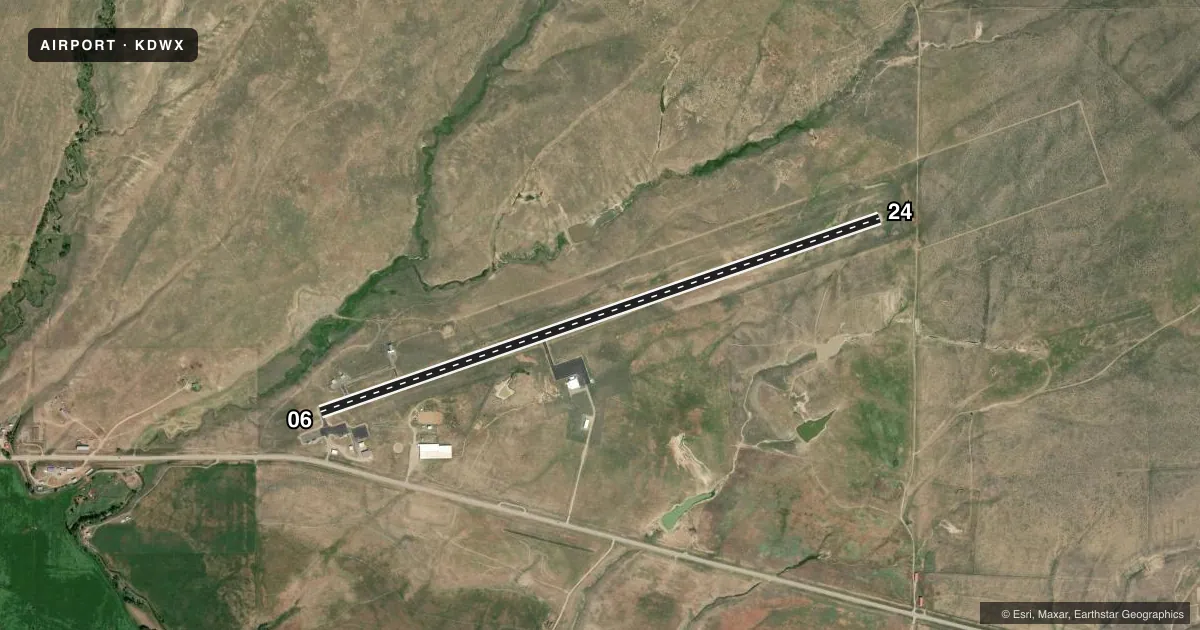
Runways & pattern
Full pagePattern entry · RWY 06
LEFT TRAFFICRunway end performance
| End | TORA | TODA | ASDA | LDA | VGSI | Approach lights | Obstruction |
|---|---|---|---|---|---|---|---|
| 06 | — | — | — | — | PAPI 2-box left(3°) | — | — |
| 24 | — | — | — | — | — | — | 8', brush, 324' from thr, 14' R of cntrln, slope 15 |
Declared distances in feet. TORA = takeoff run available, TODA = takeoff distance, ASDA = accelerate-stop, LDA = landing distance.
Airport sketch
Runways drawn to scale from FAA survey coordinates, rendered over satellite imagery. Not for navigation.
Approaches & charts
Services on the field
Fuel grades, oxygen, maintenance, ramp storage and lighting — as declared to the FAA by the airport operator.
Fuel & services
- Fuel
- 100LL
- Oxygen (bottled)
- Not available
- Oxygen (bulk)
- Not available
- Airframe repair
- Not available
- Power plant repair
- Not available
Ramp & ground
- Transient storage
- Tie-down
- Landing fee
- No fee published
- Lighting schedule
- SEE RMK
- Beacon schedule
- SS-SR
- Beacon
- White / Green (civil land)(WG)
- Wind indicator
- Lighted
- Segmented circle
- Yes
Fuel & FBOs
Cheapest 100LL and Jet A on the field and nearby. Always confirm with the FBO before taxi.
Airport notes
Surface conditions, obstructions, local procedures, lighting outages and other notes published with each FAA cycle.
General notes
- WILDLIFE ON & INVOF ARPT. 6 FT WILDLIFE FENCE ALL AROUND ARPT WITH GATED, CATTLE GUARD ENTRANCES.
- SNOW BANKS +4 FT ALONG ENTIRE RY WINTER MONTHS.
- +500 FT TERRAIN 9700 FT FM AER 24.
- FOR CD CTC DENVER ARTCC AT 303-651-4257.
- COLD TEMPERATURE AIRPORT. ALTITUDE CORRECTION REQUIRED AT OR BELOW -37C.
Lighting notes
- ACTV REILS RWY 6 & 24; PAPI RWY 6, MIRL RWY 06/24 - CTAF.
Fuel notes
- 100LLFUEL 24 HR CREDIT CARD SVC AVBL.
Other notes
- PRVDD AN OBSTN-FREE PRIMARY SFC OF 125' EITHER SIDE OF CNTRLN IS PRVDD; IF OBSTNS WITHIN APCH AREA CANNOT BE LOWERED OR REMOVED; THE THRS ARE LCTD TO PRVD A MIN 20:1 CLEARANCE OVER ALL OBSTNS.
- PILOT SUPPLIED ROPES REQUIRED FOR TIE DOWNS
VFR map & nearby airports
VFR sectional. Tap any ICAO chip to open that airport.
Key facts · KDWX
Answer card- ICAO
- KDWX
- Name
- DIXON
- Location
- DIXON, WYOMING
- Elevation
- 6,548.9 ft MSL
- Traffic pattern altitude
- 7,548.9 ft MSL (1,000 AGL)
- Control tower
- Non-towered (use CTAF)
- Total runways
- 1
- Longest runway
- 06/24 · 7,000 ft
- Published ILS approaches
- 0
- Published frequencies
- 1
- Magnetic variation
- 9°
- Current flight rules
- VFR
- Current wind
- 030° at 6 kt
- Favored runway now
- RWY 06
Dixon Airport sits in Dixon, Wyoming. Field elevation is 6,548.9 ft MSL. The airport has one runway. Runway 06/24 is 7,000 ft long and asphalt. There is no control tower. CTAF is 122.9.
No ILS approaches are published here. Pattern altitude is not published, so use standard 1,000 ft AGL for light piston operations unless the current Chart Supplement says otherwise. The field has a 6-foot wildlife fence with gated, cattle guard entrances. Wildlife is still a factor on and near the airport. Winter snow banks can also line the runway.
Dixon Airport is a cold temperature airport. Altitude correction is required at or below minus 37 degrees Celsius. Terrain rises more than 500 feet about 9,700 feet from the airport reference point. That matters on departure planning, especially on a cold day with a heavy load. Runway 06 and 24 have medium intensity lighting. Runway 6 also has a PAPI. Both ends have runway end identifier lights.
Dixon Airport is on the field. It carries AVGAS 100LL. Fuel is available 24 hours with credit card service. Pilot supplied ropes are required for tie downs. For clearance delivery, contact Denver ARTCC. Use the current Chart Supplement for any additional local procedures before you go.