METAR & TAF KCPR
Current METAR
Observed 15:53Z
KCPR 271553Z 21007KT 10SM CLR 28/11 A3010 RMK AO2 SLP111 T02780106
- Wind
- 210° @ 7 kt
- Visibility
- 10 SM
- Temp / Dew
- 28°C / 11°C
- Altimeter
- 30.10 inHg
- Clouds
- CLR
- Density alt
- 7,963 ft
- Ceiling
- Unlimited
- Rules
- VFR
Airport info & contacts
Manager on record, flight service, ARTCC, attendance schedule and pattern altitude — published by the FAA and refreshed every 28 days.
Location
- From city
- 7 NM NW
- VFR sectional
- CHEYENNE
- ARTCC
- ZDV · DENVER
- NOTAM facility
- CPR (NOTAM-D)
Airport manager
- Name
- GLENN JANUSKA
- Phone
- 307-472-6688
- Address
- 8500 AIRPORT PARKWAY, SUITE 208, CASPER WY 82604
Flight service · Hours
- FSS CPR
- CASPER1-800-WX-BRIEF
- Attendance
- ALL
Frequencies
Tap any row to copy the frequency to your clipboard.
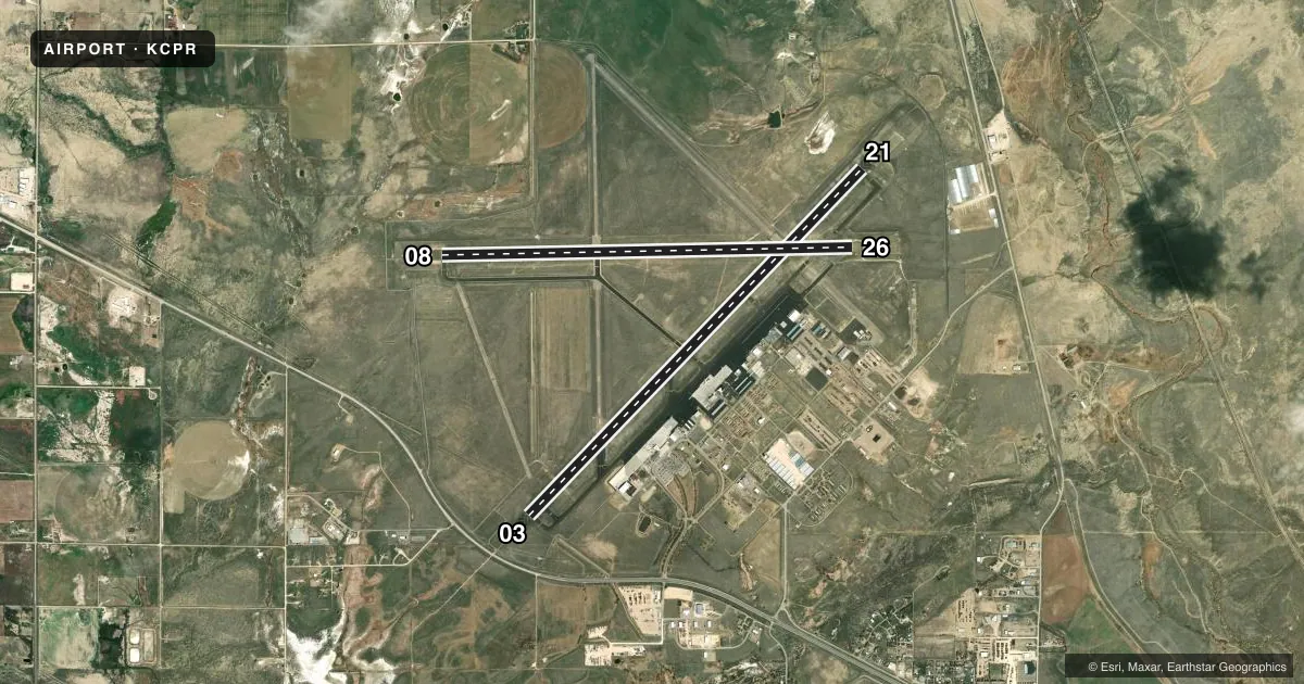
Runways & pattern
Full pagePattern entry · RWY 21
LEFT TRAFFIC| Runway | Heading (°M) | Length | Surface | Traffic |
|---|---|---|---|---|
| 03/21Favored | 32° / 212° | 10,165 ft | ASPH | Standard L |
| 08/26 | 77° / 257° | 8,679 ft | ASPH | Standard L |
Runway end performance
| End | TORA | TODA | ASDA | LDA | VGSI | Approach lights | Obstruction |
|---|---|---|---|---|---|---|---|
| 03 | 10,165' | 10,165' | 10,165' | 10,165' | PAPI 4-box right(3°) | MALSR | — |
| 21 | 10,165' | 10,165' | 10,165' | 10,165' | VASI 4-box left(3°) | — | — |
| 08 | 8,679' | 8,679' | 8,679' | 8,679' | PAPI 4-box right(3°) | MALSR | — |
| 26 | 8,679' | 8,679' | 8,679' | 8,679' | PAPI 4-box right(3°) | — | — |
Declared distances in feet. TORA = takeoff run available, TODA = takeoff distance, ASDA = accelerate-stop, LDA = landing distance.
Airport sketch
Runways drawn to scale from FAA survey coordinates, rendered over satellite imagery. Not for navigation.
Approaches & charts
ILS · 1
Services on the field
Fuel grades, oxygen, maintenance, ramp storage and lighting — as declared to the FAA by the airport operator.
Fuel & services
- Fuel
- 100LLA
- Oxygen (bottled)
- HIGH/LOW
- Oxygen (bulk)
- HIGH/LOW
- Airframe repair
- Major
- Power plant repair
- Major
- Other services
- AFRT,AMB,AVNCS,CARGO,CHTR,INSTR,RNTL,SALES,SURV
Ramp & ground
- Transient storage
- Tie-down
- Hangar
- Landing fee
- No fee published
- Customs
- Not available
- Lighting schedule
- SEE RMK
- Beacon schedule
- SS-SR
- Beacon
- White / Green (civil land)(WG)
- Wind indicator
- Lighted
- Segmented circle
- Yes
Fuel & FBOs
Cheapest 100LL and Jet A on the field and nearby. Always confirm with the FBO before taxi.
Airport notes
Surface conditions, obstructions, local procedures, lighting outages and other notes published with each FAA cycle.
General notes
- EMERG PWR AVBL RWY 08/26 & 03/21.
- RWY 08/26 & 03/21 HAVE LGTD DIST RMNG SIGNS.
- 225 FT CRANE 1 NM NE OF ARPT.
- RWYS CLSD TO FSL, TGL, AND PLA ACFT MORE THAN 250000 LBS EXC FOR 4 HRS PPR 307-995-3949.
- FOR CD CTC CASPER APCH AT 307-472-8940, WHEN APCH CLSD CTC DENVER ARTCC AT 303-651-4257.
Lighting notes
- ATC-CTL. WHEN ATCT CLSD ACTVT MALSR RWY 03 & 08; REIL RWY 21; PAPI RWY 03 & 26; HIRL RWY 03/21 & 08/26; TWY LGTS - CTAF.
Runway surface & condition
- 03/21PCR VALUE: 1190/F/C/X/T
- 08/26PCR VALUE: 1000/F/D/X/T
VFR map & nearby airports
VFR sectional. Tap any ICAO chip to open that airport.
Key facts · KCPR
Answer card- ICAO
- KCPR
- Name
- CASPER/NATRONA COUNTY INTL
- Location
- CASPER, WYOMING
- Elevation
- 5,344 ft MSL
- Traffic pattern altitude
- 6,344 ft MSL (1,000 AGL)
- Control tower
- Towered · 0500-2100
- Total runways
- 2
- Longest runway
- 03/21 · 10,165 ft
- Published ILS approaches
- 1
- Published frequencies
- 11
- Magnetic variation
- 12°
- Current flight rules
- VFR
- Current wind
- 210° at 7 kt
- Favored runway now
- RWY 21
Casper/Natrona County Intl sits in Casper, Wyoming at 5,344 ft MSL. It has two asphalt runways. The longest is 03/21 at 10,165 ft. Runway 08/26 is 8,679 ft. The field is towered from 0500 to 2100. When the tower is closed, the airport still has published lighting procedures. The MALSR works for runway 03 and 08. The REIL works for runway 21. The PAPI works for runway 03 and 26. The HIRL works on both runways. Taxiway lights are on CTAF.
There is one ILS approach. It is for runway 03. Pattern altitude is not published. Use the standard 1,000 ft AGL for light piston traffic unless ATC gives you something different. The airport is in a high-elevation part of Wyoming, so performance planning matters. Expect density altitude to be a factor, especially on warm days.
Atlantic Aviation is on the field. It carries 100LL and Jet A. Aero Center is also on the field. It carries 100LL, Jet A and Jet A Prist. A 225-foot crane sits 1 NM northeast of the airport, so keep that in mind on arrival and departure. For clearance delivery, contact Casper Approach. If approach is closed, use Denver ARTCC. Check the current FAA Chart Supplement for any current operational notes before you go.