METAR & TAF 49U
49U does not publish a METAR.
Showing the nearest reporting station: KRIW (CENTRAL WYOMING RGNL) · 18.6 NM away. Conditions at 49U may differ.
METAR · KRIW
Observed 10:53Z
KRIW 271053Z AUTO 05005KT 10SM CLR 22/09 A3011 RMK AO2 SLP107 T02220094 $
- Wind
- 050° @ 5 kt
- Visibility
- 10 SM
- Temp / Dew
- 22°C / 9°C
- Altimeter
- 30.11 inHg
- Clouds
- CLR
- Density alt
- 6,579 ft
- Ceiling
- Unlimited
- Rules
- VFR
Airport info & contacts
Manager on record, flight service, ARTCC, attendance schedule and pattern altitude — published by the FAA and refreshed every 28 days.
Location
- From city
- 1 NM N
- VFR sectional
- CHEYENNE
- ARTCC
- ZLC · SALT LAKE CITY
- NOTAM facility
- CPR (NOTAM-D)
Airport manager
- Name
- MIKE QUIVER
- Phone
- 307-876-2515
- Address
- BOX 267, SHOSHONI WY 82649
Flight service · Hours
- FSS CPR
- CASPER1-800-WX-BRIEF
- Attendance
- Unattended
Frequencies
Tap any row to copy the frequency to your clipboard.
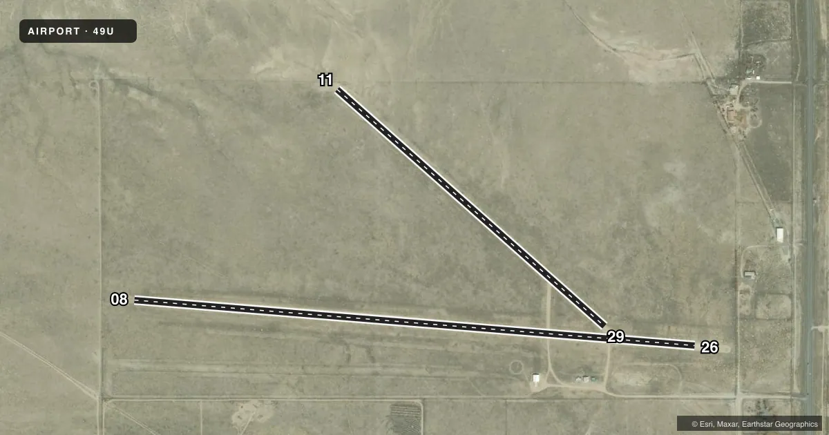
Runways & pattern
Full pagePattern entry · RWY 08
LEFT TRAFFIC| Runway | Heading (°M) | Length | Surface | Traffic |
|---|---|---|---|---|
| 08/26Favored | 81° / 261° | 4,650 ft | DIRT | Standard L |
| 11/29 | 117° / 297° | 2,950 ft | DIRT | Standard L |
Runway end performance
| End | TORA | TODA | ASDA | LDA | VGSI | Approach lights | Obstruction |
|---|---|---|---|---|---|---|---|
| 08 | — | — | — | — | — | — | 14', pline, 330' from thr, 0' R of cntrln, slope 23 |
| 26 | — | — | — | — | — | — | 7', fence, 71' from thr, slope 10 |
Declared distances in feet. TORA = takeoff run available, TODA = takeoff distance, ASDA = accelerate-stop, LDA = landing distance.
Airport sketch
Runways drawn to scale from FAA survey coordinates, rendered over satellite imagery. Not for navigation.
Approaches & charts
Services on the field
Fuel grades, oxygen, maintenance, ramp storage and lighting — as declared to the FAA by the airport operator.
Fuel & services
- Fuel
- Not available
- Oxygen (bottled)
- Not available
- Oxygen (bulk)
- Not available
- Airframe repair
- Not available
- Power plant repair
- Not available
Ramp & ground
- Transient storage
- Tie-down
- Landing fee
- No fee published
- Customs
- Not available
- Wind indicator
- Yes
- Segmented circle
- Yes
Fuel & FBOs
Cheapest 100LL and Jet A on the field and nearby. Always confirm with the FBO before taxi.
Airport notes
Surface conditions, obstructions, local procedures, lighting outages and other notes published with each FAA cycle.
General notes
- ARPT HAS UNCONTROLLED VEHICLE ACCESS.
- RYS 08/26 & 11/29 THLDS NOT MARKED.
- RY 08/26 NO LINE OF SIGHT BTN RY ENDS.
- ANTELOPE ON AIRPORT.
- FOR CD CTC SALT LAKE ARTCC AT 801-320-2568.
Other notes
- SEGEMENTED CIRCLE IS NSTD WITH ALTERNATING 4 WHITE TIRES AND 4 YELLOW TIRES. NO SPACING BETWEEN SETS.
- STRETCHED CABLE S OF HNGR AREA IN GRASS. PILOT SUPD ROPES RQRD.
- MANAGERTOWN PUBLIC WORKS DIRECTOR.
- 08/26RWY SOFT WHEN WET.
- 11/29RWY SOFT WHEN WET.
VFR map & nearby airports
VFR sectional. Tap any ICAO chip to open that airport.
Key facts · 49U
Answer card- ICAO
- 49U
- Name
- SHOSHONI MUNI
- Location
- SHOSHONI, WYOMING
- Elevation
- 4,818 ft MSL
- Traffic pattern altitude
- 5,818 ft MSL (1,000 AGL)
- Control tower
- Non-towered (use CTAF)
- Total runways
- 2
- Longest runway
- 08/26 · 4,650 ft
- Published ILS approaches
- 0
- Published frequencies
- 1
- Magnetic variation
- 14°
- Current flight rules
- VFR
- Current wind
- 050° at 5 kt
- Favored runway now
- RWY 08
Shoshoni Muni sits in Shoshoni, Wyoming at 4,818 ft MSL. It has two dirt runways. The longest is runway 08/26 at 4,650 ft. Runway 11/29 is 2,950 ft. There is no control tower. CTAF is 122.9. No ILS approaches are published here.
Pattern altitude is not published. Use the standard 1,000 ft AGL pattern for light piston aircraft unless the current Chart Supplement says otherwise. The field can be a little different from a paved strip. Both runways are soft when wet. Runway 08/26 also has no line of sight between the ends, so plan your taxi and back taxi with that in mind. Touchdown zones are not marked on either runway.
Published remarks matter here. The airport has uncontrolled vehicle access. Antelope are present on the airport. There is also a stretched cable south of the hangar area in the grass, so use ropes as required and keep a close eye on the ground when taxiing or backtracking. The segmented circle is nonstandard, so do not rely on a quick glance from the air. For clearance delivery, contact Salt Lake ARTCC at 801-320-2568. No on-field FBOs are listed, so verify fuel and service availability with the airport operator or the FBO directly by phone before you go.