METAR & TAF KCMX
Current METAR
Observed 23:53Z
KCMX 272353Z AUTO 03005KT 10SM CLR 19/16 A2979 RMK AO2 SLP085 T01940156 10222 20189 50002
- Wind
- 030° @ 5 kt
- Visibility
- 10 SM
- Temp / Dew
- 19°C / 16°C
- Altimeter
- 29.79 inHg
- Clouds
- CLR
- Density alt
- 1,999 ft
- Ceiling
- Unlimited
- Rules
- VFR
Airport info & contacts
Manager on record, flight service, ARTCC, attendance schedule and pattern altitude — published by the FAA and refreshed every 28 days.
Location
- From city
- 4 NM NE
- VFR sectional
- GREEN BAY
- ARTCC
- ZMP · MINNEAPOLIS
- NOTAM facility
- CMX (NOTAM-D)
Airport manager
- Name
- CASEY J POLKINGHORNE
- Phone
- 906-482-3970
- Address
- 23810 AIRPARK BLVD STE 113, CALUMET MI 49913-9233
Flight service · Hours
- FSS GRB
- GREEN BAY1-800-WX-BRIEF
- Attendance
- 0400-0000
Frequencies
Tap any row to copy the frequency to your clipboard.
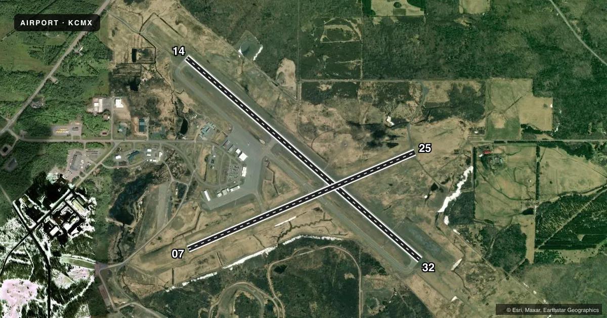
Runways & pattern
Full pagePattern entry · RWY 07
LEFT TRAFFIC| Runway | Heading (°M) | Length | Surface | Traffic |
|---|---|---|---|---|
| 14/32 | 129° / 309° | 6,501 ft | ASPH | Standard L |
| 07/25Favored | 65° / 245° | 5,201 ft | ASPH | Standard L |
Runway end performance
| End | TORA | TODA | ASDA | LDA | VGSI | Approach lights | Obstruction |
|---|---|---|---|---|---|---|---|
| 14 | 6,501' | 6,501' | 6,501' | 6,501' | PAPI 4-box left(3°) | — | 73', trees, 1872' from thr, 715' R of cntrln, slope 22 |
| 32 | 6,501' | 6,501' | 6,501' | 6,501' | PAPI 4-box left(3°) | MALSR | — |
| 07 | 5,201' | 5,201' | 5,201' | 5,201' | PAPI 2-box left(3°) | — | 55', trees, 1660' from thr, 465' R of cntrln, slope 26 |
| 25 | 5,201' | 5,201' | 5,201' | 5,201' | PAPI 4-box left(3°) | — | 51', trees, 1630' from thr, 250' R of cntrln, slope 28 |
Declared distances in feet. TORA = takeoff run available, TODA = takeoff distance, ASDA = accelerate-stop, LDA = landing distance.
Airport sketch
Runways drawn to scale from FAA survey coordinates, rendered over satellite imagery. Not for navigation.
Approaches & charts
ILS · 1
Services on the field
Fuel grades, oxygen, maintenance, ramp storage and lighting — as declared to the FAA by the airport operator.
Fuel & services
- Fuel
- 100LLA
- Airframe repair
- Major
- Power plant repair
- Major
- Other services
- INSTR
Ramp & ground
- Transient storage
- Hangar
- Landing fee
- Yes
- Customs
- Not available
- Lighting schedule
- SEE RMK
- Beacon schedule
- SS-SR
- Beacon
- White / Green (civil land)(WG)
- Wind indicator
- Lighted
- Segmented circle
- No
Fuel & FBOs
Cheapest 100LL and Jet A on the field and nearby. Always confirm with the FBO before taxi.
Airport notes
Surface conditions, obstructions, local procedures, lighting outages and other notes published with each FAA cycle.
General notes
- DEER & GULLS ON & INVOF ARPT.
- AIRFIELD GUIDANCE SIGNS SNOW COVD IN WINTER.
- PAEW ON ARPT MONITOR CTAF. FQT SNOW REMOVAL OPS IN PROGRESS AT VARIOUS TIMES OCT-APR MONITOR CTAF.
- PPR VIA UNICOM FOR PRKG IN FRONT OF AIRLINE TRML.
- FOR CD IF UNA TO CTC ON FSS FREQ, CTC MINNEAPOLIS ARTCC AT 651-463-5588.
- RWY CONDS UNMON DLY 0000-0500.
Lighting notes
- ACTVT MALSR RWY 32; REIL RWY 14; PAPI RWY 14 & 32; HIRL RWY 14/32 - CTAF. ACTVT REIL RWY 07 & 25; PAPI RWY 07 & 25; MIRL RWY 07/25; TWY B - CTC CO MAINT VIA CTAF.
Runway surface & condition
- 07/25PCR VALUE: 390/F/C/X/T
- 14/32PCR VALUE: 470/F/C/X/T
Other notes
- ARPT CLSD TO UNSKED ACR OPS WITH GTR THAN 30 PAX SEATS EXC PPR CALL AMGR.
- RPRS AVBL ON REQ - CALL AMGR.
- MANAGERCELL 906-231-2256.
VFR map & nearby airports
VFR sectional. Tap any ICAO chip to open that airport.
Key facts · KCMX
Answer card- ICAO
- KCMX
- Name
- HOUGHTON COUNTY MEML
- Location
- HANCOCK, MICHIGAN
- Elevation
- 1,095.1 ft MSL
- Traffic pattern altitude
- 2,095.1 ft MSL (1,000 AGL)
- Control tower
- Non-towered (use CTAF)
- Total runways
- 2
- Longest runway
- 14/32 · 6,501 ft
- Published ILS approaches
- 1
- Published frequencies
- 2
- Magnetic variation
- 2°
- Current flight rules
- VFR
- Current wind
- 030° at 5 kt
- Favored runway now
- RWY 07
KCMX is Houghton County Memorial Airport in Hancock, Michigan. The field elevation is 1,095.1 ft MSL. It has two asphalt runways. The longest is 6,501 ft on 14/32. There is no control tower. CTAF and UNICOM are both 122.7.
One ILS is published for runway 32. Runway 32 also has medium intensity approach lighting with runway alignment indicator lights. Runway 14 and runway 32 both have high intensity runway lights. Runway 07 and runway 25 have medium intensity runway lights. Pattern altitude is not published. Use the standard 1,000 ft AGL for light piston traffic unless the current FAA Chart Supplement says otherwise.
Houghton County Memorial Airport has one on-field FBO. Houghton County Memorial Airport carries 100LL, Jet A and Jet A Prist. If you need service or repairs, the remarks say repairs are available on request by calling the manager. The airport also notes frequent snow removal from October through April. Deer and gulls are reported on and near the field. The airport is closed to unscheduled aircraft operations with more than 30 passenger seats unless prior permission is obtained. For a first-time arrival, expect winter ops to matter here. Taxiway and runway guidance signs can be snow covered in winter. Monitor CTAF closely.