METAR & TAF KBLI
Current METAR
Observed 19:53Z
KBLI 271953Z 20008G16KT 10SM BKN100 21/14 A3006 RMK AO2 SLP183 T02060139
- Wind
- 200° @ 8G16 kt
- Visibility
- 10 SM
- Temp / Dew
- 21°C / 14°C
- Altimeter
- 30.06 inHg
- Clouds
- BKN
- Density alt
- 758 ft
- Ceiling
- 10,000 ft AGL
- Rules
- VFR
Airport info & contacts
Manager on record, flight service, ARTCC, attendance schedule and pattern altitude — published by the FAA and refreshed every 28 days.
Location
- From city
- 3 NM NW
- VFR sectional
- SEATTLE
- Pattern altitude
- 1,030 ft AGL · 1,201 ft MSL
- ARTCC
- ZVR · VANCOUVER
- NOTAM facility
- BLI (NOTAM-D)
Airport manager
- Name
- MATT RODRIGUEZ
- Phone
- 360-676-2500
- Address
- 4255 MITCHELL WAY, SUITE 206, BELLINGHAM WA 98226
Flight service · Hours
- FSS SEA
- SEATTLE1-800-WX-BRIEF
- Attendance
- ALL
Frequencies
Tap any row to copy the frequency to your clipboard.
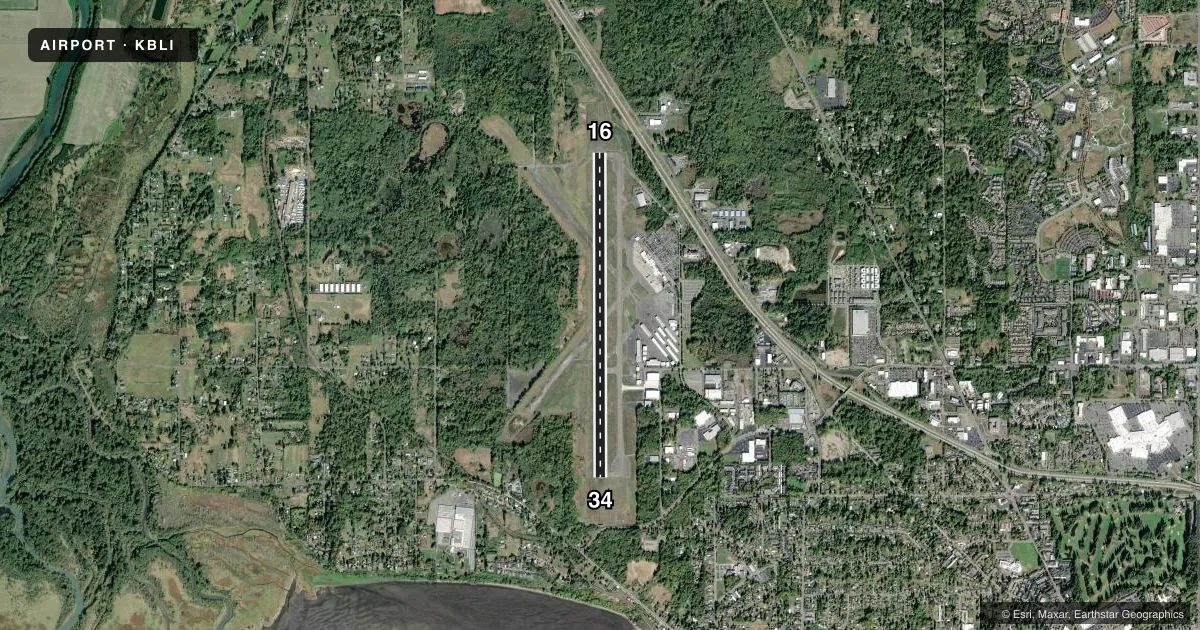
Runways & pattern
Full pagePattern entry · RWY 16
RIGHT TRAFFICRunway end performance
| End | TORA | TODA | ASDA | LDA | VGSI | Approach lights | Obstruction |
|---|---|---|---|---|---|---|---|
| 16 | 6,700' | 6,700' | 6,700' | 6,700' | PAPI 4-box left(3°) | MALSR | — |
| 34 | 6,700' | 6,700' | 6,700' | 6,700' | PAPI 4-box left(3°) | — | — |
Declared distances in feet. TORA = takeoff run available, TODA = takeoff distance, ASDA = accelerate-stop, LDA = landing distance.
Airport sketch
Runways drawn to scale from FAA survey coordinates, rendered over satellite imagery. Not for navigation.
Approaches & charts
ILS · 1
Services on the field
Fuel grades, oxygen, maintenance, ramp storage and lighting — as declared to the FAA by the airport operator.
Fuel & services
- Fuel
- 100LLA
- Airframe repair
- Not available
- Power plant repair
- Major
- Other services
- AFRT,AVNCS,CARGO,CHTR,INSTR,RNTL
Ramp & ground
- Transient storage
- Tie-down
- Landing fee
- Yes
- Customs
- Available
- Lighting schedule
- SEE RMK
- Beacon schedule
- SS-SR
- Beacon
- White / Green (civil land)(WG)
- Wind indicator
- Lighted
- Segmented circle
- Yes
Fuel & FBOs
Cheapest 100LL and Jet A on the field and nearby. Always confirm with the FBO before taxi.
Airport notes
Surface conditions, obstructions, local procedures, lighting outages and other notes published with each FAA cycle.
General notes
- BIRDS & WILDLIFE ON & INVOF ARPT.
- TWY A BTN TWY E & F CLSD TO WINGSPAN GTR THAN 118FT. PORTIONS OF TWY A AT TWY G & J NOT VIS FM ATCT.
- NOISE ABATEMENT PROC IN EFCT - 360-739-1944.
- COML RAMP CLSD TO PVT ACFT.
- ACR OPS USE TWY A, TWY B, TWY C, TWY D WEST OF TWY E, TWY E, TWY F WEST OF TWY A, TWY G & TWY H.
- FLIGHT NOTIFICATION SERVICE (ADCUS) AVBL.
- FOR CD WHEN ATCT IS CLSD, CTC VICTORIA TRML ON 132.7 OR AT 604-586-4561.
Lighting notes
- WHEN ATCT CLSD ACTVT MALSR RWY 16; REIL RWY 34; HIRL RWY 16/34 - CTAF.
Runway surface & condition
- 16/34PCR VALUE: 739/F/D/X/T
Other notes
- ESTABD PRIOR TO 1959.
- PPR FOR UNSKED ACR OPS GTR THAN 30 PAX SEATS - 360-739-1944.
- OVR 7500 LB.
- TPA 1030 FT AGL FIXED WING; 530 FT AGL HELICOPTER; 1830 FT AGL TURBO.
VFR map & nearby airports
VFR sectional. Tap any ICAO chip to open that airport.
Key facts · KBLI
Answer card- ICAO
- KBLI
- Name
- BELLINGHAM INTL
- Location
- BELLINGHAM, WASHINGTON
- Elevation
- 171 ft MSL
- Traffic pattern altitude
- 1,201 ft MSL (1,030 AGL)
- Control tower
- Towered · 0700-2230
- Total runways
- 1
- Longest runway
- 16/34 · 6,700 ft
- Published ILS approaches
- 1
- Published frequencies
- 8
- Magnetic variation
- 16°
- Current flight rules
- VFR
- Current wind
- 200° at 8 kt
- Favored runway now
- RWY 16
Bellingham Intl sits in Bellingham, Washington. Field elevation is 171 ft MSL. The airport has one runway, 16/34, at 6,700 ft. Tower service is published 0700-2230. There is one ILS approach. It serves runway 16. Pattern altitude for fixed wing aircraft is 1,030 ft AGL, which is 1,201 ft MSL.
Bellingham Aviation Services is the on-field FBO. It carries AVGAS 100LL, Jet A and Jet A Prist. Noise abatement procedures are in effect. Plan to brief that before arrival. Flight notification service is available. The airport also publishes prior permission for unscheduled aircraft operations greater than 30 passenger seats.
For a first-time pilot, the main things to watch are the towered environment, the noise abatement rules and the mixed traffic picture on the field. Birds and wildlife are present on and near the airport. Taxiway A has a published closure for aircraft with wingspans greater than 118 feet between taxiways E and F. Portions of taxiway A at taxiways G and J are not visible from the tower. When the tower is closed, clearance delivery is handled through Victoria Terminal on 132.7.