METAR & TAF KALO
Current METAR
Observed 18:54Z
KALO 271854Z 28006KT 10SM FEW023 34/28 A2969 RMK AO2 SLP045 T03390283
- Wind
- 280° @ 6 kt
- Visibility
- 10 SM
- Temp / Dew
- 34°C / 28°C
- Altimeter
- 29.69 inHg
- Clouds
- FEW
- Density alt
- 3,648 ft
- Ceiling
- Unlimited
- Rules
- VFR
Airport info & contacts
Manager on record, flight service, ARTCC, attendance schedule and pattern altitude — published by the FAA and refreshed every 28 days.
Location
- From city
- 4 NM NW
- VFR sectional
- CHICAGO
- ARTCC
- ZMP · MINNEAPOLIS
- NOTAM facility
- ALO (NOTAM-D)
Airport manager
- Name
- MR. STEVEN KJERGAARD
- Phone
- 319-291-4483
- Address
- 2790 LIVINGSTON LANE, WATERLOO IA 50703
Flight service · Hours
- FSS FOD
- FORT DODGE1-800-WX-BRIEF
- Attendance
- 0500-2100
Frequencies
Tap any row to copy the frequency to your clipboard.
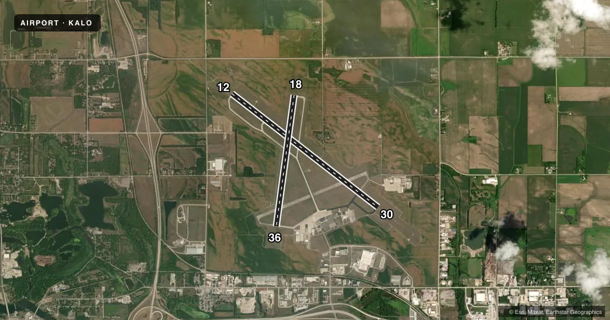
Runways & pattern
Full pagePattern entry · RWY 30
LEFT TRAFFIC| Runway | Heading (°M) | Length | Surface | Traffic |
|---|---|---|---|---|
| 12/30Favored | 128° / 308° | 8,399 ft | ASPH | Standard L |
| 18/36 | 188° / 8° | 6,003 ft | ASPH-CONC | Standard L |
Runway end performance
| End | TORA | TODA | ASDA | LDA | VGSI | Approach lights | Obstruction |
|---|---|---|---|---|---|---|---|
| 12 | 8,399' | 8,399' | 8,399' | 8,399' | PAPI 4-box left(3°) | MALSR | 107', tree, 5200' from thr, 1000' R of cntrln, slope 46 |
| 30 | 8,399' | 8,399' | 8,399' | 8,399' | VASI 4-box left(3°) | MALS | — |
| 18 | 6,003' | 6,003' | 6,003' | 6,003' | VASI 4-box left(3°) | — | 75', tree, 1875' from thr, 450' R of cntrln, slope 22 |
| 36 | 6,003' | 6,003' | 6,003' | 6,003' | PAPI 4-box left(3°) | — | 50', tree, 2300' from thr, 250' R of cntrln, slope 42 |
Declared distances in feet. TORA = takeoff run available, TODA = takeoff distance, ASDA = accelerate-stop, LDA = landing distance.
Airport sketch
Runways drawn to scale from FAA survey coordinates, rendered over satellite imagery. Not for navigation.
Approaches & charts
ILS · 1
Services on the field
Fuel grades, oxygen, maintenance, ramp storage and lighting — as declared to the FAA by the airport operator.
Fuel & services
- Fuel
- 100LLA
- Oxygen (bottled)
- HIGH/LOW
- Oxygen (bulk)
- HIGH/LOW
- Airframe repair
- Major
- Power plant repair
- Major
- Other services
- AMB,CHTR,INSTR,RNTL
Ramp & ground
- Transient storage
- Tie-down
- Hangar
- Landing fee
- No fee published
- Customs
- Not available
- Lighting schedule
- SEE RMK
- Beacon schedule
- SS-SR
- Beacon
- White / Green (civil land)(WG)
- Wind indicator
- Lighted
- Segmented circle
- No
Fuel & FBOs
Cheapest 100LL and Jet A on the field and nearby. Always confirm with the FBO before taxi.
Airport notes
Surface conditions, obstructions, local procedures, lighting outages and other notes published with each FAA cycle.
General notes
- BIRDS ON & INVOF ARPT.
- RWY 30 IS CALM WIND RWY.
- WHEN DEPARTING ALL RWYS, ENDS OF OTHER RWYS NOT VISIBLE.
- WHEN ATCT CLSD & DURG SNOW EVENTS, ALL ARR/DEP ACFT ANNC THEIR INTNS ON CTAF 5 MIN PRIOR TO USING THE RWYS.
- PERSONNEL & EQUP PERFORMING SNOW REMOVAL OPNS WILL MONITOR CTAF.
- ARNG: ARNG OPS CTC DSN 431-5520, C319-234-1372.
- ARPT SFC CONDS UNMON 2200-0430 DAILY.
- FOR CD IF UNA ON 121.9 CTC WATERLOO ATCT AT 319-233-4835. WHEN WATERLOO ATCT CLSD, FOR CD CTC MINNEAPOLIS ARTCC AT 651-463-5588.
- ACR NA TWY A EAST OF RWY 12/30.
- TWY A LGT BTN RWY 12/30 & ARMY AVN SUPPORT RAMP NA.
Lighting notes
- WHEN ATCT CLSD ACTVT MALSR RWY 12; MALS RWY 30; VASI RWY 18; PAPI RWY 36; MIRL RWYS 18/36, AND HIRL RWY 12/30 - CTAF.
Fuel notes
- 100LLFUEL AVBL ON REQ. FEE FOR SVCS.
Runway surface & condition
- 12/30PCR VALUE: 513/F/B/X/T
- 18/36PCR VALUE: 202/F/B/X/T
Other notes
- CLSD TO UNSKED ACR OPNS WITH MORE THAN 10 PSGR SEATS EXCP 72 HRS PPR AMGR. CALL AMGR 319-291-4483. CELL 319-529-1388 ARFF INDEX B PROVIDED. ARFF INDEX C AVBL ON 72 HRS REQ. AIR CARRIER OPS OVER 9 PSGR SEATS NOT AUTH OVER 15 MINUTES BEFORE OR AFTER SKED ARR OR DEP TIMES EXCP WITH PRIOR COORD WITH AMGR.
- AMBCAR RENTAL
VFR map & nearby airports
VFR sectional. Tap any ICAO chip to open that airport.
Key facts · KALO
Answer card- ICAO
- KALO
- Name
- WATERLOO RGNL
- Location
- WATERLOO, IOWA
- Elevation
- 873 ft MSL
- Traffic pattern altitude
- 1,873 ft MSL (1,000 AGL)
- Control tower
- Towered · 0600-2000
- Total runways
- 2
- Longest runway
- 12/30 · 8,399 ft
- Published ILS approaches
- 1
- Published frequencies
- 12
- Magnetic variation
- 0°
- Current flight rules
- VFR
- Current wind
- 280° at 6 kt
- Favored runway now
- RWY 30
Waterloo Rgnl sits in Waterloo, Iowa at 873 ft MSL. It has two runways. The longest is 12/30 at 8,399 ft. The other runway is 18/36 at 6,003 ft. The field is towered from 0600 to 2000. When the tower is closed, use the published lighting procedures on CTAF for the runway you plan to use. One ILS approach is available for runway 12. Pattern altitude is not published. Use 1,000 ft AGL for light piston traffic unless the current Chart Supplement says otherwise. That puts the pattern at 1,873 ft MSL here.
Livingston Aviation is on the field. It carries 100LL, Jet A and Jet A Prist. Birds are reported on and near the airport, so keep a sharp scan on arrival and departure. Airport surface conditions are unmonitored from 2200 to 0430 daily. That matters if you are planning a late arrival or early departure. Runway 30 is the calm wind runway. Taxiway A lighting between runway 12/30 and the Army Aviation Support Ramp is not available. Plan your ground movement with that in mind. The airport also notes that ends of the other runways are not visible when departing any runway.