METAR & TAF KACP
Current METAR
Observed 07:55Z
KACP 120755Z AUTO 00000KT 1 1/2SM BR SCT007 BKN012 23/22 A2998 RMK AO2
- Wind
- 000° @ 0 kt
- Visibility
- 0.5 SM
- Temp / Dew
- 23°C / 22°C
- Altimeter
- 29.98 inHg
- Clouds
- BKN
- Density alt
- 1,018 ft
- Ceiling
- 1,200 ft AGL
- Rules
- LIFR
Airport info & contacts
Manager on record, flight service, ARTCC, attendance schedule and pattern altitude — published by the FAA and refreshed every 28 days.
Location
- From city
- 4 NM S
- VFR sectional
- HOUSTON
- ARTCC
- ZHU · HOUSTON
- NOTAM facility
- DRI (NOTAM-D)
Airport manager
- Name
- JOEL B JOHNSON
- Phone
- 318-215-0090
- Address
- 278 AIRPORT ROAD, OAKDALE LA 71463
Flight service · Hours
- FSS DRI
- DE RIDDER1-800-WX-BRIEF
- Attendance
- ALL
Frequencies
Tap any row to copy the frequency to your clipboard.
Runways & pattern
Full pagePattern entry · RWY 18
LEFT TRAFFICRunway end performance
| End | TORA | TODA | ASDA | LDA | VGSI | Approach lights | Obstruction |
|---|---|---|---|---|---|---|---|
| 18 | — | — | — | — | PAPI 2-box left(3°) | — | 58', trees, 1380' from thr, 333' R of cntrln, slope 20 |
| 36 | — | — | — | — | PAPI 2-box left(3°) | — | 45', trees, 406' from thr, 152' R of cntrln, slope 4 |
Declared distances in feet. TORA = takeoff run available, TODA = takeoff distance, ASDA = accelerate-stop, LDA = landing distance.
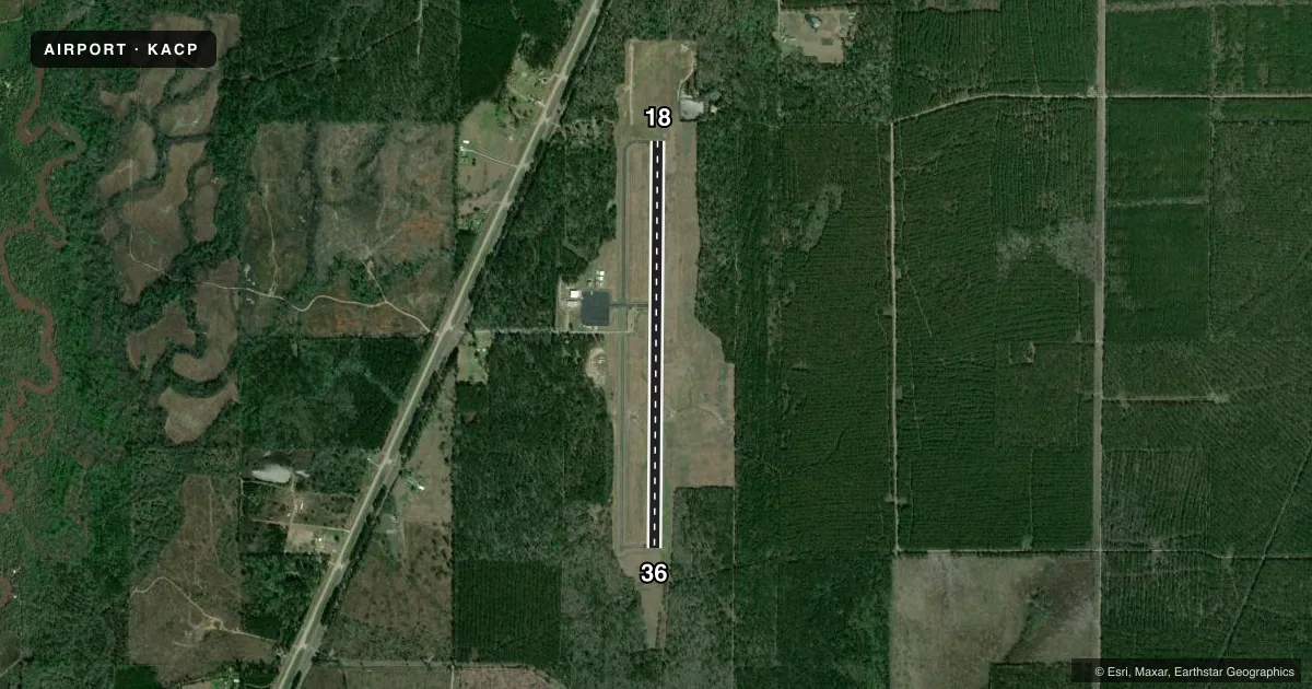
Airport sketch
Runways drawn to scale from FAA survey coordinates, rendered over satellite imagery. Not for navigation.
Approaches & charts
Services on the field
Fuel grades, oxygen, maintenance, ramp storage and lighting — as declared to the FAA by the airport operator.
Fuel & services
- Fuel
- 100LLA
- Oxygen (bottled)
- Not available
- Oxygen (bulk)
- Not available
- Airframe repair
- Not available
- Power plant repair
- Not available
- Other services
- AGRI
Ramp & ground
- Transient storage
- Tie-down
- Hangar
- Landing fee
- No fee published
- Customs
- Not available
- Lighting schedule
- SEE RMK
- Beacon schedule
- SS-SR
- Beacon
- White / Green (civil land)(WG)
- Wind indicator
- Lighted
- Segmented circle
- No
Fuel & FBOs
Cheapest 100LL and Jet A on the field and nearby. Always confirm with the FBO before taxi.
Airport notes
Surface conditions, obstructions, local procedures, lighting outages and other notes published with each FAA cycle.
General notes
- GCO AVBL ON FREQ 135.075 THRU MAKS APCH CTL & FLT SVCS.
- STANDING WATER ON RUNWAY AT MIDFIELD AFTER RAIN.
- FOR CD IF UNA VIA GCO, CTC MAKS APCH AT 726-780-0456.
- CTC ARPT MGR FOR DSNGD RAMP SPACE FOR PUB USE AT ARPT
Lighting notes
- MIRL RY 18/36 & REIL RYS 18 & 36 PRESET LOW INTST DUSK-DAWN; TO INCR INTST ACTVT - CTAF.
Fuel notes
- 100LLFUEL AVBL SELF SERVICE WITH CREDIT CARD.
- AFUEL AVBL SELF SERVICE WITH CREDIT CARD.
VFR map & nearby airports
VFR sectional. Tap any ICAO chip to open that airport.
Key facts · KACP
Answer card- ICAO
- KACP
- Name
- ALLEN PARISH
- Location
- OAKDALE, LOUISIANA
- Elevation
- 107.1 ft MSL
- Traffic pattern altitude
- 1,107.1 ft MSL (1,000 AGL)
- Control tower
- Non-towered (use CTAF)
- Total runways
- 1
- Longest runway
- 18/36 · 5,000 ft
- Published ILS approaches
- 0
- Published frequencies
- 4
- Magnetic variation
- 3°
- Current flight rules
- LIFR
- Current wind
- 000° at 0 kt
- Favored runway now
- –
Allen Parish Airport (KACP) sits in Oakdale, Louisiana. Field elevation is 107.1 ft MSL. The airport has one runway. Runway 18/36 is 5,000 ft asphalt, which is the longest runway on the field. There is no control tower. Pattern altitude is not published. For light piston traffic, use 1,000 ft AGL unless current local guidance says otherwise.
No ILS approaches are published here. The field uses CTAF 122.8 and UNICOM 122.8. MAKS Approach and flight services are on 123.7 and 261.3. A ground communications outlet is also available on 135.075 through MAKS Approach control and flight services. If clearance delivery is not available through the ground communications outlet, contact MAKS Approach at 726-780-0456.
Allen Parish Airport carries self-serve 100LL and self-serve Jet A with credit card. The on-field FBO is Allen Parish Airport. It also carries AVGAS 100LL and JET A PRIST. Runway lights on 18/36 and the runway end identifier lights are preset low from dusk to dawn. Use CTAF to increase intensity. One operational item to plan for is standing water at midfield after rain. The airport manager handles designated ramp space for public use, so call ahead if you need parking guidance.