METAR & TAF F01
F01 does not publish a METAR.
Showing the nearest reporting station: KCDS (CHILDRESS MUNI) · 27.8 NM away. Conditions at F01 may differ.
METAR · KCDS
Observed 16:53Z
KCDS 251653Z AUTO 24012G18KT 10SM FEW110 34/19 A3006 RMK AO2 SLP147 T03440194
- Wind
- 240° @ 12G18 kt
- Visibility
- 10 SM
- Temp / Dew
- 34°C / 19°C
- Altimeter
- 30.06 inHg
- Clouds
- FEW
- Density alt
- 4,094 ft
- Ceiling
- Unlimited
- Rules
- VFR
Airport info & contacts
Manager on record, flight service, ARTCC, attendance schedule and pattern altitude — published by the FAA and refreshed every 28 days.
Location
- From city
- 2 NM SW
- VFR sectional
- DALLAS-FT WORTH
- ARTCC
- ZFW · FORT WORTH
- NOTAM facility
- FTW (NOTAM-D)
Airport manager
- Name
- CITY ADMINISTRATOR
- Phone
- 940-663-5336
- Address
- 109 KING ST, P.O. BOX 629, QUANAH TX 79252
Flight service · Hours
- FSS FTW
- FORT WORTH1-800-WX-BRIEF
- Attendance
- Unattended
Frequencies
Tap any row to copy the frequency to your clipboard.
Runways & pattern
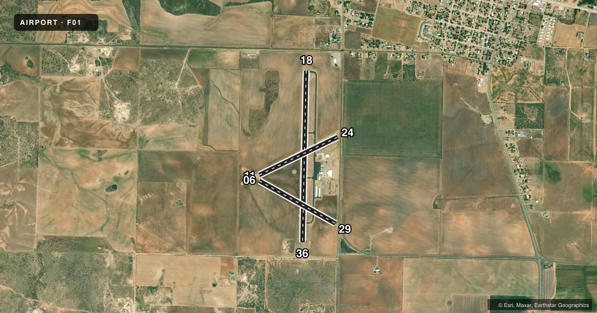
Full pagePattern entry · RWY 24
LEFT TRAFFIC| Runway | Heading (°M) | Length | Surface | Traffic |
|---|---|---|---|---|
| 18/36 | 173° / 353° | 4,452 ft | ASPH | Standard L |
| 11/29 | 111° / 291° | 2,270 ft | TURF | Standard L |
| 06/24Favored | 56° / 236° | 2,268 ft | TURF | Standard L |
Runway end performance
| End | TORA | TODA | ASDA | LDA | VGSI | Approach lights | Obstruction |
|---|---|---|---|---|---|---|---|
| 18 | — | — | — | — | — | — | 15', road, 550' from thr, 0' R of cntrln, slope 23 |
| 36 | — | — | — | — | PAPI 2-box left(3°) | — | — |
| 29 | — | — | — | — | — | — | 15', road, 135' from thr, 0' R of cntrln, slope 9 |
| 24 | — | — | — | — | — | — | 24', pole, 150' from thr, 150' R of cntrln, slope 6 |
Declared distances in feet. TORA = takeoff run available, TODA = takeoff distance, ASDA = accelerate-stop, LDA = landing distance.
Airport sketch
Runways drawn to scale from FAA survey coordinates, rendered over satellite imagery. Not for navigation.
Approaches & charts
Services on the field
Fuel grades, oxygen, maintenance, ramp storage and lighting — as declared to the FAA by the airport operator.
Fuel & services
- Fuel
- 100LL
- Oxygen (bottled)
- Not available
- Oxygen (bulk)
- Not available
- Airframe repair
- Not available
- Power plant repair
- Not available
- Other services
- AGRI
Ramp & ground
- Transient storage
- Tie-down
- Hangar
- Landing fee
- No fee published
- Customs
- Not available
- Lighting schedule
- SEE RMK
- Beacon schedule
- SS-SR
- Beacon
- White / Green (civil land)(WG)
- Wind indicator
- Lighted
- Segmented circle
- Yes
Fuel & FBOs
Cheapest 100LL and Jet A on the field and nearby. Always confirm with the FBO before taxi.
Airport notes
Surface conditions, obstructions, local procedures, lighting outages and other notes published with each FAA cycle.
General notes
- WIDTH OF TURF RWYS BASED ON THE AREA MOWED.
- FOR CD CTC FORT WORTH ARTCC AT 817-858-7584.
Lighting notes
- MIRL RWY 18/36 PRESET LOW INTST; TO INCR INTST ACTVT - CTAF.
Fuel notes
- 100LLFOR FUEL OR MAINT CALL 940-839-7257.
Approach & departure obstructions
- 24DSPLCD THR UNMARKED.
- 29DSPLCD THR UNMARKED.
Other notes
- MANAGERCITY/AMGR.
VFR map & nearby airports
VFR sectional. Tap any ICAO chip to open that airport.
Key facts · F01
Answer card- ICAO
- F01
- Name
- QUANAH MUNI
- Location
- QUANAH, TEXAS
- Elevation
- 1,603.2 ft MSL
- Traffic pattern altitude
- 2,603.2 ft MSL (1,000 AGL)
- Control tower
- Non-towered (use CTAF)
- Total runways
- 3
- Longest runway
- 18/36 · 4,452 ft
- Published ILS approaches
- 0
- Published frequencies
- 2
- Magnetic variation
- 8°
- Current flight rules
- VFR
- Current wind
- 240° at 12 kt
- Favored runway now
- RWY 24
Quanah Muni is in Quanah, Texas. The field elevation is 1,603.2 ft MSL. It has three runways. The longest is runway 18/36 at 4,452 ft on asphalt. The other two are turf strips, 11/29 at 2,270 ft and 06/24 at 2,268 ft. There is no control tower. CTAF and UNICOM are both 122.7.
No ILS approaches are published here. Pattern altitude is not published, so a light piston pilot should plan on the standard 1,000 ft AGL unless the current Chart Supplement says otherwise. The published remarks matter here. Runway 29 has an unmarked displaced threshold. Runway 24 also has an unmarked displaced threshold. Runway 18/36 has medium intensity lights that come up at low intensity by default. Use the CTAF to increase them if needed.
Quanah Municipal Airport is the on-field FBO. It carries 100LL. For fuel or maintenance, the published number is 940-839-7257. If you need clearance delivery, contact Fort Worth ARTCC at 817-858-7584. This is a non-towered field with a 4,452 ft paved runway, so it is a straightforward stop for most light aircraft. The turf runways are mowed areas, so check surface condition before you plan to use them. Verify any current noise or operational notes with the current FAA Chart Supplement before flight.