METAR & TAF F00
Current METAR
Observed 03:15Z
KF00 120315Z AUTO 12003KT 10SM CLR 28/24 A2989 RMK AO2
- Wind
- 120° @ 3 kt
- Visibility
- 10 SM
- Temp / Dew
- 28°C / 24°C
- Altimeter
- 29.89 inHg
- Clouds
- CLR
- Density alt
- 2,364 ft
- Ceiling
- Unlimited
- Rules
- VFR
Airport info & contacts
Manager on record, flight service, ARTCC, attendance schedule and pattern altitude — published by the FAA and refreshed every 28 days.
Location
- From city
- 2 NM N
- VFR sectional
- DALLAS-FT WORTH
- ARTCC
- ZFW · FORT WORTH
- NOTAM facility
- FTW (NOTAM-D)
Airport manager
- Name
- ZACK WHITLOCK
- Phone
- 903-583-8623
- Address
- 514 CHESTNUT, BONHAM TX 75418
Flight service · Hours
- FSS FTW
- FORT WORTH1-800-WX-BRIEF
- Attendance
- Unattended
Frequencies
Tap any row to copy the frequency to your clipboard.
Runways & pattern
Full pagePattern entry · RWY 17
LEFT TRAFFICRunway end performance
| End | TORA | TODA | ASDA | LDA | VGSI | Approach lights | Obstruction |
|---|---|---|---|---|---|---|---|
| 17 | — | — | — | — | PAPI 2-box left(3°) | — | 22', trees, 540' from thr, 260' R of cntrln, slope 15 |
| 35 | — | — | — | — | PAPI 2-box left(3°) | — | 18', ant, 425' from thr, 175' R of cntrln, slope 12 |
Declared distances in feet. TORA = takeoff run available, TODA = takeoff distance, ASDA = accelerate-stop, LDA = landing distance.
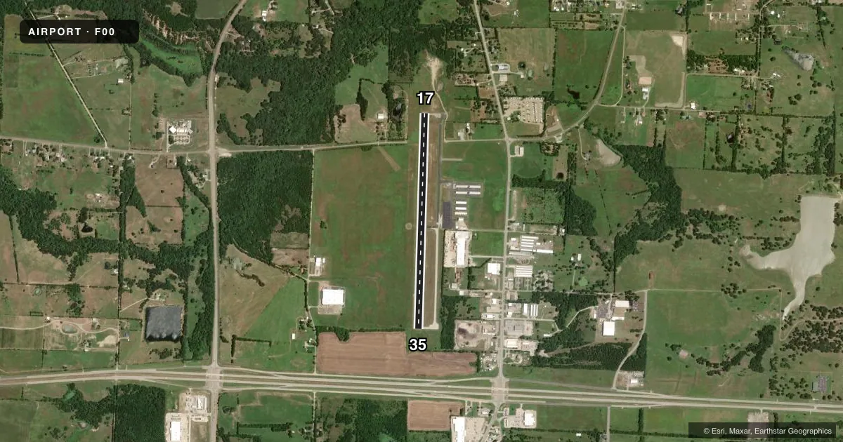
Airport sketch
Runways drawn to scale from FAA survey coordinates, rendered over satellite imagery. Not for navigation.
Approaches & charts
Services on the field
Fuel grades, oxygen, maintenance, ramp storage and lighting — as declared to the FAA by the airport operator.
Fuel & services
- Fuel
- 100LLA+
- Oxygen (bottled)
- Not available
- Oxygen (bulk)
- Not available
- Airframe repair
- Major
- Power plant repair
- Major
- Other services
- AGRI
Ramp & ground
- Transient storage
- Tie-down
- Landing fee
- No fee published
- Customs
- Not available
- Lighting schedule
- SEE RMK
- Beacon schedule
- SS-SR
- Beacon
- White / Green (civil land)(WG)
- Wind indicator
- Lighted
- Segmented circle
- Yes
Fuel & FBOs
Cheapest 100LL and Jet A on the field and nearby. Always confirm with the FBO before taxi.
Airport notes
Surface conditions, obstructions, local procedures, lighting outages and other notes published with each FAA cycle.
General notes
- FOR CD CTC FORT WORTH ARTCC AT 817-858-7584.
- EXTSV AERIAL AG OPS APR-AUG. OTR TIMES IREG.
Lighting notes
- MIRL RWY 17 & 35 SS-SR PRESET LOW; TO ACTVT OR INCR INTST - CTAF. PAPI RWY 17 & PAPI RWY 35 OPR CONSLY.
Fuel notes
- 100LL100 LL SELF-SERV.
- A+JET A FULL SERV. CALL 903-227-5199.
Approach & departure obstructions
- 3533 FT TREES, 0-50 FT DSTC, 239 FT L; 4 FT FENCE, 0-100 FT DSTC, 190 FT L.
- 17ALSO 43 FT PLINE, 1315 FT DSTC, 225 L/R, 25:1.
Other notes
- FOR AIRFRAME REPAIRS CALL 903-640-0233 OR 903-583-5119.
- UNICOM UNMONITORED.
- 2FOR ARPT ATTENDANT CALL 903-583-7555 M-F 8:00-5:00. AFT HRS CALL BONHAM POLICE DEPT 903-583-2141.
- MANAGERDIRECTOR OF PUBLIC WORKS.
VFR map & nearby airports
VFR sectional. Tap any ICAO chip to open that airport.
Key facts · F00
Answer card- ICAO
- F00
- Name
- JONES FLD
- Location
- BONHAM, TEXAS
- Elevation
- 618.2 ft MSL
- Traffic pattern altitude
- 1,618.2 ft MSL (1,000 AGL)
- Control tower
- Non-towered (use CTAF)
- Total runways
- 1
- Longest runway
- 17/35 · 4,000 ft
- Published ILS approaches
- 0
- Published frequencies
- 2
- Magnetic variation
- 6°
- Current flight rules
- VFR
- Current wind
- 120° at 3 kt
- Favored runway now
- RWY 17
Jones Field sits in Bonham, Texas at 618.2 ft MSL. It has one runway, 17/35 and the longest runway is 4,000 ft of asphalt. The field is non-towered. CTAF and UNICOM are both 122.8, though UNICOM is unmonitored. No ILS approaches are published here.
Pattern altitude is not published, so use the standard 1,000 ft AGL for light piston traffic unless the current FAA Chart Supplement says otherwise. The runway lights are preset low from sunset to sunrise. Use CTAF to raise intensity or turn them up. PAPI on 17 and 35 operate continuously. There is a 43-foot power line near the approach to runway 17. Near runway 35, expect trees and a fence close to the runway environment.
Jones Field has Jones Field FBO on site. It carries 100LL. Jet A is also available as full service. Call the field directly before arrival if you need current service details. The airport sees extensive aerial agricultural traffic from April through August. That matters for spacing and scan discipline. Clearance delivery is handled through Fort Worth ARTCC when needed. First-time arrivals should plan for a quiet non-towered field with local traffic. Expect ag ops in season. Watch the close-in obstructions on both ends.