METAR & TAF TJCP
TJCP does not publish a METAR.
Showing the nearest reporting station: TIST (CYRIL E KING) · 18.9 NM away. Conditions at TJCP may differ.
METAR · TIST
Observed 09:53Z
TIST 260953Z AUTO 09008KT 10SM CLR 26/08 A3002
- Wind
- 090° @ 8 kt
- Visibility
- 10 SM
- Temp / Dew
- 26°C / 8°C
- Altimeter
- 30.02 inHg
- Clouds
- CLR
- Density alt
- 1,249 ft
- Ceiling
- Unlimited
- Rules
- VFR
Airport info & contacts
Manager on record, flight service, ARTCC, attendance schedule and pattern altitude — published by the FAA and refreshed every 28 days.
Location
- From city
- 1 NM N
- VFR sectional
- PUERTO RICO-VIRGIN ISLANDS
- ARTCC
- ZSU · SAN JUAN
- NOTAM facility
- TJSJ (NOTAM-D)
Airport manager
- Name
- SIGFREDO RIVERA MELENDEZ
- Phone
- 787-742-0022
- Address
- PO BOX 362829, SAN JUAN PR 00936-2829
Flight service · Hours
- FSS SJU
- SAN JUAN1-800-WX-BRIEF
- Attendance
- SR-SS
Frequencies
Tap any row to copy the frequency to your clipboard.
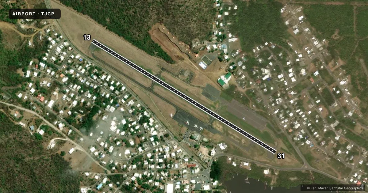
Runways & pattern
Full pagePattern entry · RWY 13
LEFT TRAFFICRunway end performance
| End | TORA | TODA | ASDA | LDA | VGSI | Approach lights | Obstruction |
|---|---|---|---|---|---|---|---|
| 13 | — | — | — | — | — | — | 480', hill, 2200' from thr, 0' R of cntrln, slope 4 |
| 31 | — | — | — | — | — | — | 6', fence, 201' from thr, 80' R of cntrln, slope 0 |
Declared distances in feet. TORA = takeoff run available, TODA = takeoff distance, ASDA = accelerate-stop, LDA = landing distance.
Airport sketch
Runways drawn to scale from FAA survey coordinates, rendered over satellite imagery. Not for navigation.
Approaches & charts
Services on the field
Fuel grades, oxygen, maintenance, ramp storage and lighting — as declared to the FAA by the airport operator.
Fuel & services
- Fuel
- Not available
- Oxygen (bottled)
- Not available
- Oxygen (bulk)
- Not available
- Airframe repair
- Not available
- Power plant repair
- Not available
- Other services
- CHTR
Ramp & ground
- Transient storage
- Not published
- Landing fee
- Yes
- Customs
- Not available
- Lighting schedule
- SEE RMK
- Beacon schedule
- SS-SR
- Beacon
- White / Green (civil land)(WG)
- Wind indicator
- Lighted
- Segmented circle
- No
Fuel & FBOs
Cheapest 100LL and Jet A on the field and nearby. Always confirm with the FBO before taxi.
Airport notes
Surface conditions, obstructions, local procedures, lighting outages and other notes published with each FAA cycle.
General notes
- LOW ALT MANEUVERING REQUIRED FOR FINAL ALIGNMENT TO RWY. VARIABLE DEGS OF TURBULENCE MAY BE EXPECTED.
- ACFT DEPARTING ARPT NORTHBOUND BE ALERT FOR TRAFFIC DESCENDING ON FINAL FOR CHARLOTTE AMALIE ST THOMAS, CYRIL E KING (STT).
- BIRDS ON & INVOF ARPT.
- UNATNDD SS-SR. EMERGS ONLY. OPNS BETWEEN SS-SR WILL BE AN OWN RISK.
- LDG FEE FOR ALL ACFT.
- 600 FT AGL ANT 1/2 MILE EAST OF ARPT.
- RWY 13, 480 FT HILL, 1/2 MILE FROM RWY END.
- RAPIDLY RISING TERRAIN NW.
- FOR CD CTC SAN JUAN CERAP AT 787-253-8664/8665
Lighting notes
- RWY 13/31 MIRL-CTAF.
Approach & departure obstructions
- 316 FT FENCE, 0-200 FT DSTC, 90-150 FT R/L; 15 ROAD, 0-200 FT DSTC, 100-150 FT R/L.
Other notes
- VFR WX ONLY. MIN TRAFFIC PTN 1000' AGL. NO NGT OPNS. LND RWY 13 ONLY (EXCP FOR ADVERSE WX CONDS) APCH FM NW THRU BAHIA FLAMENCO ON HEADING OF 172 DEG. FLY THRU LAGUNA DEL FLAMENCO UNTIL APROX PARALLEL TO HIWAY IN PASS ALTER HEADING TO 153 DEG; LEFT TURN TO FINAL APCH RWY 13.
- MANAGERON SITE MGR.
- OWNEREXT 5300
- 13/31LOOSE STONES ON ALL SFC.
VFR map & nearby airports
VFR sectional. Tap any ICAO chip to open that airport.
Key facts · TJCP
Answer card- ICAO
- TJCP
- Name
- BENJAMIN RIVERA NORIEGA
- Location
- ISLA DE CULEBRA, PUERTO RICO
- Elevation
- 42.9 ft MSL
- Traffic pattern altitude
- 1,042.9 ft MSL (1,000 AGL)
- Control tower
- Non-towered (use CTAF)
- Total runways
- 1
- Longest runway
- 13/31 · 2,596 ft
- Published ILS approaches
- 0
- Published frequencies
- 1
- Magnetic variation
- 11°
- Current flight rules
- VFR
- Current wind
- 090° at 8 kt
- Favored runway now
- RWY 13
Benjamin Rivera Noriega Airport sits on Isla de Culebra, Puerto Rico. Field elevation is 42.9 ft MSL. It has one runway, 13/31, which is 2,596 ft long. The airport is uncontrolled. CTAF is 122.9. No ILS approaches are published.
Pattern altitude is not published in the source data. Use the standard 1,000 ft AGL for light piston operations unless the current FAA Chart Supplement says otherwise. The field is unattended from sunset to sunrise. Night operations are not allowed. Published remarks also call for VFR weather only. Runway 13 is the preferred landing runway except in adverse weather. The published arrival note for runway 13 calls for an approach from the northwest through Bahia Flamenco, then through Laguna del Flamenco, with a left turn to final. That means a tight visual setup with low-altitude maneuvering. Expect turbulence on final.
There are no on-field FBOs listed. Check with the airport operator or the FBO directly by phone before arrival if you need fuel or ramp details. The runway and taxiway pavement has cracking and loose stones. Birds are on and near the runway. A 600 ft AGL antenna sits about half a mile east of the airport. Rapidly rising terrain is northwest of the field. Aircraft departing northbound should also watch for traffic descending on final for Charlotte Amalie St Thomas, Cyril E King.