METAR & TAF TJVQ
TJVQ does not publish a METAR.
Showing the nearest reporting station: TJRV (JOSE APONTE DE LA TORRE) · 10.8 NM away. Conditions at TJVQ may differ.
METAR · TJRV
Observed 01:53Z
TJRV 270153Z 11006KT 10SM FEW030 26/21 A3001 RMK AO2A SLP164 T02560206 METAR KNBC 270056Z COR 7SM CLR 19/15 A3012 RMK AO2 SLP200 T01890150 $ METAR OEPS 270155Z 29012KT 9999 FEW120 BKN140 18/11 A2991 RMK AO2A SLPNO METAR KMMT 270155Z AUTO 18006KT 10SM CLR 22/14 A3004 RMK AO2 SLP174 T02220143 $
- Wind
- 180° @ 6 kt
- Visibility
- 10 SM
- Temp / Dew
- 22°C / 14°C
- Altimeter
- 30.04 inHg
- Clouds
- BKN
- Density alt
- 751 ft
- Ceiling
- 14,000 ft AGL
- Rules
- VFR
Airport info & contacts
Manager on record, flight service, ARTCC, attendance schedule and pattern altitude — published by the FAA and refreshed every 28 days.
Location
- From city
- 3 NM SW
- VFR sectional
- PUERTO RICO-VIRGIN ISLANDS
- ARTCC
- ZSU · SAN JUAN
- NOTAM facility
- TJSJ (NOTAM-D)
Airport manager
- Name
- RAMN RODRGUEZ VZQUEZ
- Phone
- 787-741-0585
- Address
- ANTONIO RIVERA RODRIGUEZ AIRPORT, HC 1 BOX 9421, VIEQUES PR 00765-9243
Flight service · Hours
- FSS SJU
- SAN JUAN1-800-WX-BRIEF
- Attendance
- 0600-1800
Frequencies
Tap any row to copy the frequency to your clipboard.
Runways & pattern
Full pagePattern entry · RWY 27
RIGHT TRAFFICRunway end performance
| End | TORA | TODA | ASDA | LDA | VGSI | Approach lights | Obstruction |
|---|---|---|---|---|---|---|---|
| 09 | 4,294' | 4,294' | 4,294' | 4,094' | PAPI 4-box left(3°) | — | 15', trees, 201' from thr, 70' R of cntrln, slope 0 |
| 27 | 4,294' | 4,294' | 4,294' | 4,094' | — | — | 19', road, 201' from thr, 220' R of cntrln, slope 0 |
Declared distances in feet. TORA = takeoff run available, TODA = takeoff distance, ASDA = accelerate-stop, LDA = landing distance.
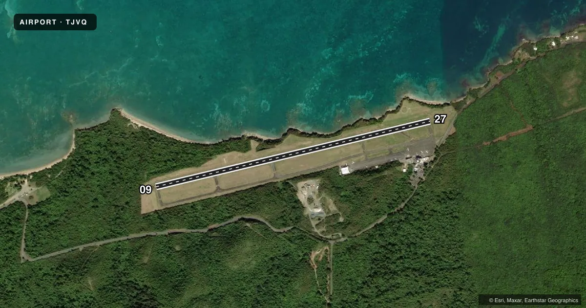
Airport sketch
Runways drawn to scale from FAA survey coordinates, rendered over satellite imagery. Not for navigation.
Approaches & charts
Services on the field
Fuel grades, oxygen, maintenance, ramp storage and lighting — as declared to the FAA by the airport operator.
Fuel & services
- Fuel
- Not available
- Oxygen (bottled)
- Not available
- Oxygen (bulk)
- Not available
- Airframe repair
- Not available
- Power plant repair
- Not available
Ramp & ground
- Transient storage
- Tie-down
- Landing fee
- Yes
- Customs
- Not available
- Beacon schedule
- SS-SR
- Beacon
- White / Green (civil land)(WG)
- Wind indicator
- Lighted
- Segmented circle
- Yes
Fuel & FBOs
Cheapest 100LL and Jet A on the field and nearby. Always confirm with the FBO before taxi.
Airport notes
Surface conditions, obstructions, local procedures, lighting outages and other notes published with each FAA cycle.
General notes
- CLSD TO SKED AIR CARRIER OPER WITH MORE THAN 9 PSGR SEATS AND UNSKED AIR CARRIER OPER WITH MORE THAN 30 PSGR SEATS.
- PPR FOR OTHER B-III ACFT & MAX WINGSPAN OF 88.75 FT, CTC AMGR.
- RISING TERRAIN SOUTH.
- FOR CD CTC SAN JUAN CERAP AT 787-253-8664/8665
- ACFT NOT VISIBLE FROM OPPOSITE RWY END.
- LOOSE STONES ALL SFCS.
Approach & departure obstructions
- 0915 FT. TREES, 0-199 FT. DSTC, 100 FT. L.
- 278 FT. 0-199 FT. DSTC, 145 FT. R, 19 FT RD, 199 FT DSTC, 220 FT L.
- 09RWY 09 PAPI BYD 9 DEG R OF RCL UNUSBL.
- 09APCH RATIO 17:1 TO DTHR OVER 35 FT. TREES, 622 FT. DSTC, 195 FT. R. ALSO 25 FT TREE, 492 FT. DSTC, 100 FT R OBSTN CLNC SLOPE 11:1.
Other notes
- VFR OPNS ONLY.
- LDG FEE FOR ALL ACFT.
- UNICOM MONITORED DURING ATTND. HRS.
- MANAGERAFTR HRS PH 787-439-5941.
- OWNEREXT 5300
VFR map & nearby airports
VFR sectional. Tap any ICAO chip to open that airport.
Key facts · TJVQ
Answer card- ICAO
- TJVQ
- Name
- ANTONIO RIVERA RODRIGUEZ
- Location
- ISLA DE VIEQUES, PUERTO RICO
- Elevation
- 48.2 ft MSL
- Traffic pattern altitude
- 1,048.2 ft MSL (1,000 AGL)
- Control tower
- Non-towered (use CTAF)
- Total runways
- 1
- Longest runway
- 09/27 · 4,294 ft
- Published ILS approaches
- 0
- Published frequencies
- 2
- Magnetic variation
- 13°
- Current flight rules
- VFR
- Current wind
- 180° at 6 kt
- Favored runway now
- RWY 27
Antonio Rivera Rodriguez Airport (TJVQ) sits on Isla de Vieques in Puerto Rico. Field elevation is 48.2 ft MSL. The airport has one runway, 09/27, which is 4,294 ft long. There is no control tower. CTAF and UNICOM are both 123.0. No ILS approaches are published here. Pattern altitude is not published, so use the standard 1,000 ft AGL unless the current FAA Chart Supplement says otherwise. That puts the light aircraft pattern at about 1,048 ft MSL based on the field elevation.
A few published remarks matter here. Runway 09 has a displaced threshold marked 200 ft from the end. There are trees near both ends, so pay close attention to the approach path. Runway 9 day landing length is 4,094 ft. Night landing length is 3,405 ft. Rising terrain is south of the field. The rotating beacon is out of service indefinitely. UNICOM is monitored during attended hours.
No on-field FBOs are listed in the facts. Contact the airport operator directly or call the field on CTAF or UNICOM for current service and ramp details. A landing fee applies for all aircraft. Pilots planning larger aircraft should note the published prior permission requirement for other B-III aircraft and the maximum wingspan limit of 88.75 ft. Check the current FAA Chart Supplement for any noise or operating restrictions before you go.