METAR & TAF TISX
Current METAR
Observed 03:53Z
TISX 260353Z 07009KT 10SM FEW018 28/24 A3006
- Wind
- 070° @ 9 kt
- Visibility
- 10 SM
- Temp / Dew
- 28°C / 24°C
- Altimeter
- 30.06 inHg
- Clouds
- FEW
- Density alt
- 1,477 ft
- Ceiling
- Unlimited
- Rules
- VFR
Airport info & contacts
Manager on record, flight service, ARTCC, attendance schedule and pattern altitude — published by the FAA and refreshed every 28 days.
Location
- From city
- 6 NM SW
- VFR sectional
- PUERTO RICO-VIRGIN ISLANDS
- ARTCC
- ZSU · SAN JUAN
- NOTAM facility
- TISX (NOTAM-D)
Airport manager
- Name
- JEROME SHERIDAN
- Phone
- 340-714-6662
- Address
- P.O. BOX 1134, CHRISTIANSTED, ST CROIX VI 00821
Flight service · Hours
- FSS SJU
- SAN JUAN1-800-WX-BRIEF
- Attendance
- 0500-2300
Frequencies
Tap any row to copy the frequency to your clipboard.
Runways & pattern
Full pagePattern entry · RWY 10
RIGHT TRAFFICRunway end performance
| End | TORA | TODA | ASDA | LDA | VGSI | Approach lights | Obstruction |
|---|---|---|---|---|---|---|---|
| 10 | — | — | — | — | PAPI 4-box left(3°) | MALSR | — |
| 28 | — | — | — | — | PAPI 4-box left(3°) | — | 217', bldg, 5330' from thr, 800' R of cntrln, slope 23 |
Declared distances in feet. TORA = takeoff run available, TODA = takeoff distance, ASDA = accelerate-stop, LDA = landing distance.
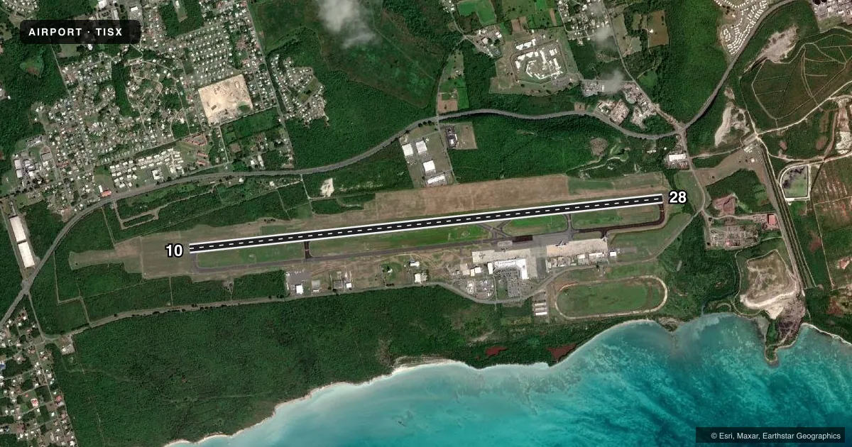
Airport sketch
Runways drawn to scale from FAA survey coordinates, rendered over satellite imagery. Not for navigation.
Approaches & charts
ILS · 1
Services on the field
Fuel grades, oxygen, maintenance, ramp storage and lighting — as declared to the FAA by the airport operator.
Fuel & services
- Fuel
- 100LLA1+
- Oxygen (bottled)
- Not available
- Oxygen (bulk)
- Not available
- Airframe repair
- Not available
- Power plant repair
- Not available
- Other services
- AVNCS
Ramp & ground
- Transient storage
- Hangar
- Landing fee
- Yes
- Customs
- Not available
- Lighting schedule
- SEE RMK
- Beacon schedule
- SS-SR
- Beacon
- White / Green (civil land)(WG)
- Wind indicator
- Lighted
- Segmented circle
- Yes
Fuel & FBOs
Cheapest 100LL and Jet A on the field and nearby. Always confirm with the FBO before taxi.
Airport notes
Surface conditions, obstructions, local procedures, lighting outages and other notes published with each FAA cycle.
General notes
- APCH TO RY 28 SMTMS OBSCD BY SMOKE FM LANDFILL LCTD E OF ARPT.
- BIRDS & WILDLIFE ON & INVOF ARPT.
- WHEN TWR CLSD CTC SAN JUAN CERAP AT 787-253-8664/8665
- AP SFC COND UNMON DLY 2300 - 0600 AST.
- PILOTS CONDUCTING EFVS OPS; BE AWARE LED ALS IN USE RWY 10.
Lighting notes
- ACTVT MALSR RWY 10: HIRL RWY 10/28 2300-0700 - CTAF.
Fuel notes
- 100LLFUEL AVBL 0700-1900, OTHER TIMES 1 HR PPR CALL 340-778-9177.
Runway surface & condition
- 10/28PCR VALUE: 1750/F/A/X/T
Other notes
- CLSD TO UNSKED ACR OPNS WITH MORE THAN 30 PSGR SEATS EXCP 24 HRS PPR CTC AMGR 340-778-1012. ARFF SVC UNAVBL 2300-0500.
VFR map & nearby airports
VFR sectional. Tap any ICAO chip to open that airport.
Key facts · TISX
Answer card- ICAO
- TISX
- Name
- HENRY E ROHLSEN
- Location
- CHRISTIANSTED, VIRGIN ISLANDS
- Elevation
- 73.2 ft MSL
- Traffic pattern altitude
- 1,073.2 ft MSL (1,000 AGL)
- Control tower
- Towered · 0700-2200
- Total runways
- 1
- Longest runway
- 10/28 · 10,002 ft
- Published ILS approaches
- 1
- Published frequencies
- 8
- Magnetic variation
- 13°
- Current flight rules
- VFR
- Current wind
- 070° at 9 kt
- Favored runway now
- RWY 10
Henry E Rohlsen is in Christiansted, Virgin Islands. Field elevation is 73.2 ft MSL. The airport has one runway, 10/28, which is 10,002 ft long. The tower is open from 0700 to 2200. One ILS approach is published for runway 10. Pattern altitude is not published in the facts, so a light piston pilot should use the standard 1,000 ft AGL unless the current Chart Supplement says otherwise.
Bohlke International Aviation is on the field. It carries 100LL and Jet A. 100LL is available from 0700 to 1900. Outside those hours, call ahead for permission. Runway 10 has medium intensity approach lighting with runway alignment indicator lights. High intensity runway lights for 10 and 28 operate from 2300 to 0700 on CTAF. The airport also has a note about runway 28. Smoke from the landfill east of the airport can obscure the approach at times.
This is a busy island field with wildlife on and near the airport. Surface condition is not monitored daily from 2300 to 0600 Atlantic Standard Time. When the tower is closed, contact San Juan Center Radar Approach Control. The field is at low elevation, so density altitude is usually less of a factor than at mountain airports. Still, plan for island weather, traffic flow and the published lighting and approach notes before you go in.