METAR & TAF TIST
Current METAR
Observed 08:53Z
TIST 270853Z AUTO 08005KT 10SM CLR 28/08 A2999
- Wind
- 080° @ 5 kt
- Visibility
- 10 SM
- Temp / Dew
- 28°C / 8°C
- Altimeter
- 29.99 inHg
- Clouds
- CLR
- Density alt
- 1,502 ft
- Ceiling
- Unlimited
- Rules
- VFR
Airport info & contacts
Manager on record, flight service, ARTCC, attendance schedule and pattern altitude — published by the FAA and refreshed every 28 days.
Location
- From city
- 2 NM W
- VFR sectional
- PUERTO RICO-VIRGIN ISLANDS
- ARTCC
- ZSU · SAN JUAN
- NOTAM facility
- TIST (NOTAM-D)
Airport manager
- Name
- JEROME SHERIDAN
- Phone
- (340) 714-6667
- Address
- CYRIL E. KING AIRPORT, P.O. BOX 301707, ST THOMAS VI 00802
Flight service · Hours
- FSS SJU
- SAN JUAN1-800-WX-BRIEF
- Attendance
- 0700-2300
Frequencies
Tap any row to copy the frequency to your clipboard.
Runways & pattern
Full pagePattern entry · RWY 10
RIGHT TRAFFICRunway end performance
| End | TORA | TODA | ASDA | LDA | VGSI | Approach lights | Obstruction |
|---|---|---|---|---|---|---|---|
| 10 | 7,000' | 7,000' | 6,892' | 6,892' | PAPI 4-box left(3°) | — | pole, slope 50 |
| 28 | 7,000' | 7,000' | 6,170' | 3,870' | — | — | 28', pole, 300' from thr, 400' R of cntrln, slope 3 |
Declared distances in feet. TORA = takeoff run available, TODA = takeoff distance, ASDA = accelerate-stop, LDA = landing distance.
Airport sketch
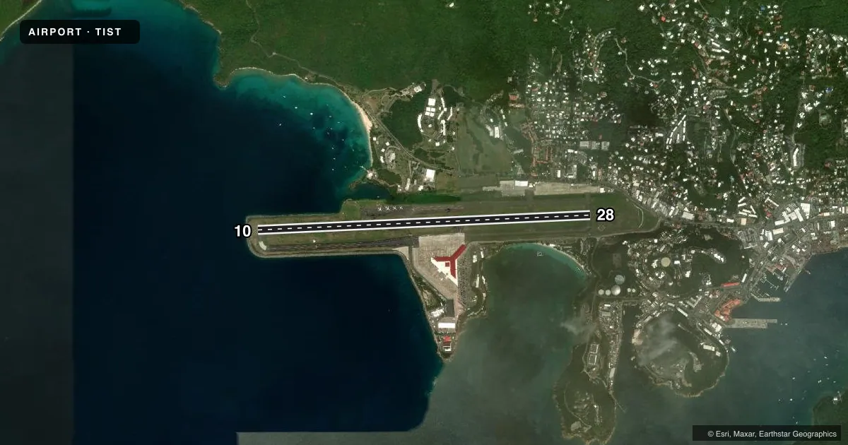
Runways drawn to scale from FAA survey coordinates, rendered over satellite imagery. Not for navigation.
Approaches & charts
ILS · 1
Services on the field
Fuel grades, oxygen, maintenance, ramp storage and lighting — as declared to the FAA by the airport operator.
Fuel & services
- Fuel
- 100LLA
- Oxygen (bottled)
- Not available
- Oxygen (bulk)
- Not available
- Airframe repair
- Minor
- Power plant repair
- Minor
- Other services
- AFRT,AMB,CARGO,CHTR,INSTR
Ramp & ground
- Transient storage
- Tie-down
- Hangar
- Landing fee
- Yes
- Customs
- Not available
- Lighting schedule
- SEE RMK
- Beacon schedule
- SS-SR
- Beacon
- White / Green (civil land)(WG)
- Wind indicator
- Lighted
- Segmented circle
- Yes
Fuel & FBOs
Cheapest 100LL and Jet A on the field and nearby. Always confirm with the FBO before taxi.
Airport notes
Surface conditions, obstructions, local procedures, lighting outages and other notes published with each FAA cycle.
General notes
- ACFT THAT BACK TAXI FOR DEP ON RY 28 SHALL MAKE THEIR 180 DEG TURN CCLKWS.
- NOISE SENSITIVE AREA: AVOID OVERFLIGHTS OF WATER ISLAND LOCATED 2 MI SE OF ARPT.
- PILOTS MAY ENCTR FALSE ILLUSORY INDICATIONS DURG NGT VISUAL APCHS TO RY 10 WHEN USING VISUAL CUES FOR VERTICAL GUIDANCE; RCMD USE OF THE ILS GS & FQT CROSS REF WITH THE ACFT ALTM TO MAINT THE PROPER APCH PROFILE.
- LGTS ON HILL 4 NM SE OF ARPT MAY BE MISTAKEN FOR RY 10/28 WHEN MAKING A VISUAL APCH FROM THE SOUTH.
- RY 10 DEPS MAINTAIN RY HDG UNTIL REACHING DEP END OF RY BFR TURNING ON COURSE OR ASSIGNED HDG UNLESS OTRW AUZD BY ATCT.
- ARFF UNAVBL 2300-0600.
- PILOTS CTC GND CTL PRIOR TO PUSHBACK.
- OBSTRUCTION SAILBOAT MAST 100FT WEST OF APPROACH END OF RWY 10 50FT AGL
- WHEN TWR CLSD CTC SAN JUAN CERAP AT 787-253-8664/8665
Lighting notes
- HIRL RWY 10/28 OPER DUSK-2300. AFTER 2300, ACTVT HIRL RWY 10/28 - CTAF. ACTVT PAPI RWY 10 AND REIL RWY 10 - CTAF.
Fuel notes
- 100LLFUEL AVBL 0700-1900, OTHER TIMES PPR CALL 340-777-9177, 340-772-8093, 340-715-3821
Runway surface & condition
- 10/28PCR VALUE: 790/F/A/X/T
Approach & departure obstructions
- 1050 FT SAILBOAT MAST 100 FT WEST OF APCH END OF RWY 10.
Other notes
- CLSD TO UNSKED ACR OPNS WITH MORE THAN 30 PSGR SEATS EXCP 24 HRS PPR CALL AMGR 340-714-6667.
VFR map & nearby airports
VFR sectional. Tap any ICAO chip to open that airport.
Key facts · TIST
Answer card- ICAO
- TIST
- Name
- CYRIL E KING
- Location
- CHARLOTTE AMALIE, VIRGIN ISLANDS
- Elevation
- 23.6 ft MSL
- Traffic pattern altitude
- 1,023.6 ft MSL (1,000 AGL)
- Control tower
- Towered · 0700-2230, ATCT CLOSES 1 HR EARLIER DRG DALGT SAVINGS TIME.
- Total runways
- 1
- Longest runway
- 10/28 · 7,000 ft
- Published ILS approaches
- 1
- Published frequencies
- 9
- Magnetic variation
- 13°
- Current flight rules
- VFR
- Current wind
- 080° at 5 kt
- Favored runway now
- RWY 10
Cyril E King sits in Charlotte Amalie in the U.S. Virgin Islands. Field elevation is 23.6 ft MSL. The airport has one runway. Runway 10/28 is 7,000 ft long with an asphalt surface. The control tower is open 0700 to 2230. In daylight saving time, the tower closes 1 hour earlier. Pattern altitude is not published. Use 1,000 ft AGL for light piston traffic unless you get other instructions.
There is one ILS approach. It serves runway 10. That matters here because the field has a few visual traps. A sailboat mast sits 100 ft west of the runway 10 approach end at 50 ft AGL. Night visual approaches to runway 10 can also give false cues. Use the ILS glide slope and keep a close cross-check on the altimeter. Lights on a hill 4 NM southeast of the airport can also be mistaken for the runway from the south.
On the field, Standard Aviation, St. Thomas Jet Center and Execujet Flight Services are listed. Standard Aviation and St. Thomas Jet Center carry 100LL, JET A and JET A PRIST. Execujet Flight Services carries JET A. Fuel is available from 0700 to 1900. After hours, call ahead for permission. Runway 10/28 high intensity lights are available from dusk to 2300. After 2300, activate them on CTAF. Runway 28 back taxi departures require a counterclockwise 180 degree turn. When the tower is closed, contact San Juan CERAP before arrival.