METAR & TAF X63
X63 does not publish a METAR.
Showing the nearest reporting station: TJRV (JOSE APONTE DE LA TORRE) · 11.0 NM away. Conditions at X63 may differ.
METAR · TJRV
Observed 01:53Z
TJRV 270153Z 11006KT 10SM FEW030 26/21 A3001 RMK AO2A SLP164 T02560206 METAR KNBC 270056Z COR 7SM CLR 19/15 A3012 RMK AO2 SLP200 T01890150 $ METAR OEPS 270155Z 29012KT 9999 FEW120 BKN140 18/11 A2991 RMK AO2A SLPNO METAR KMMT 270155Z AUTO 18006KT 10SM CLR 22/14 A3004 RMK AO2 SLP174 T02220143 $
- Wind
- 180° @ 6 kt
- Visibility
- 10 SM
- Temp / Dew
- 22°C / 14°C
- Altimeter
- 30.04 inHg
- Clouds
- BKN
- Density alt
- 734 ft
- Ceiling
- 14,000 ft AGL
- Rules
- VFR
Airport info & contacts
Manager on record, flight service, ARTCC, attendance schedule and pattern altitude — published by the FAA and refreshed every 28 days.
Location
- From city
- 1 NM SE
- VFR sectional
- PUERTO RICO-VIRGIN ISLANDS
- ARTCC
- ZSU · SAN JUAN
- NOTAM facility
- TJSJ (NOTAM-D)
Airport manager
- Name
- RAMN RODRGUEZ VZQUEZ
- Phone
- 787-852-8188
- Address
- P.O BOX 972, PUNTA SANTIAGO PR 00741-0972
Flight service · Hours
- FSS SJU
- SAN JUAN1-800-WX-BRIEF
- Attendance
- MON-FRI · 0730-1600
Frequencies
Tap any row to copy the frequency to your clipboard.
Runways & pattern
Full pagePattern entry · RWY 10
LEFT TRAFFICRunway end performance
| End | TORA | TODA | ASDA | LDA | VGSI | Approach lights | Obstruction |
|---|---|---|---|---|---|---|---|
| 10 | — | — | — | — | — | — | 45', tree, 530' from thr, 100' R of cntrln, slope 7 |
Declared distances in feet. TORA = takeoff run available, TODA = takeoff distance, ASDA = accelerate-stop, LDA = landing distance.
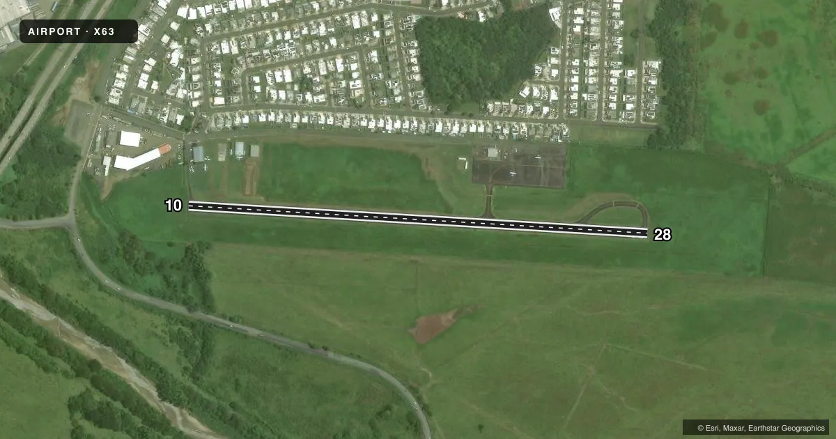
Airport sketch
Runways drawn to scale from FAA survey coordinates, rendered over satellite imagery. Not for navigation.
Approaches & charts
Services on the field
Fuel grades, oxygen, maintenance, ramp storage and lighting — as declared to the FAA by the airport operator.
Fuel & services
- Fuel
- Not available
- Oxygen (bottled)
- Not available
- Oxygen (bulk)
- Not available
- Airframe repair
- Not available
- Power plant repair
- Not available
- Other services
- PAJA
Ramp & ground
- Transient storage
- Tie-down
- Landing fee
- Yes
- Customs
- Not available
- Lighting schedule
- SS-SR
- Beacon schedule
- SS-SR
- Beacon
- White / Green (civil land)(WG)
- Wind indicator
- Lighted
- Segmented circle
- No
Fuel & FBOs
Cheapest 100LL and Jet A on the field and nearby. Always confirm with the FBO before taxi.
Airport notes
Surface conditions, obstructions, local procedures, lighting outages and other notes published with each FAA cycle.
General notes
- ULTRALIGHT OPNS ON ARPT.
- TWO-WAY RADIO COMMUNICATION REQUIRED FOR ALL ACFT & VEHICLES EXCP BY PRIOR REQUEST; CALL 787-852-8188.
- BIRD ACTIVITY ON AND INVOF ARPT.
- RISING TERRAIN INVOF ARPT.
- FOR CD CTC SAN JUAN CERAP AT 787-253-8664/8665
Other notes
- VFR OPNS ONLY.
- 10/28LOOSE STONES AND GRAVEL ON RWY & TXY.
VFR map & nearby airports
VFR sectional. Tap any ICAO chip to open that airport.
Key facts · X63
Answer card- ICAO
- X63
- Name
- DR HERMENEGILDO ORTIZ QUINONES
- Location
- HUMACAO, PUERTO RICO
- Elevation
- 34.8 ft MSL
- Traffic pattern altitude
- 1,034.8 ft MSL (1,000 AGL)
- Control tower
- Non-towered (use CTAF)
- Total runways
- 1
- Longest runway
- 10/28 · 2,457 ft
- Published ILS approaches
- 0
- Published frequencies
- 1
- Magnetic variation
- 11°
- Current flight rules
- VFR
- Current wind
- 180° at 6 kt
- Favored runway now
- RWY 10
DR Hermenegildo Ortiz Quinones is in Humacao, Puerto Rico. The field elevation is 34.8 ft MSL. It has one runway, 10/28, which is 2,457 ft long and paved. There is no control tower. CTAF is 122.8. No ILS approaches are published here.
The pattern altitude is not published. Use 1,000 ft AGL for light piston traffic unless the current Chart Supplement says otherwise. This is a VFR-only field. That matters here because the airport sits in a busy local operating environment with skydiving and ultralight activity. Bird activity is also reported on and near the airport. Loose stones and gravel are present on the runway and taxiway, so a careful taxi and runup makes sense.
Two-way radio communication is required for all aircraft and vehicles except by prior request. The airport phone number is 787-852-8188. For clearance delivery, contact San Juan CERAP at 787-253-8664 or 787-253-8665. Rising terrain is in the vicinity of the airport. Cattle have been reported 500 ft from the threshold of runway 28. They can occasionally be on the runway, so plan your arrival and rollout with that in mind.