METAR & TAF TJAB
TJAB does not publish a METAR.
Showing the nearest reporting station: TJBQ (RAFAEL HERNANDEZ) · 26.0 NM away. Conditions at TJAB may differ.
METAR · TJBQ
Observed 00:50Z
TJBQ 260050Z 09013KT 10SM SCT015 28/26 A3008
- Wind
- 090° @ 13 kt
- Visibility
- 10 SM
- Temp / Dew
- 28°C / 26°C
- Altimeter
- 30.08 inHg
- Clouds
- SCT
- Density alt
- 1,387 ft
- Ceiling
- Unlimited
- Rules
- VFR
Airport info & contacts
Manager on record, flight service, ARTCC, attendance schedule and pattern altitude — published by the FAA and refreshed every 28 days.
Location
- From city
- 3 NM SE
- VFR sectional
- PUERTO RICO-VIRGIN ISLANDS
- ARTCC
- ZSU · SAN JUAN
- NOTAM facility
- TJSJ (NOTAM-D)
Airport manager
- Name
- EDGAR M. TORRELLAS
- Phone
- 787-881-2072
- Address
- 1079 SANTANA, ARECIBO PR 00612-6614
Flight service · Hours
- FSS SJU
- SAN JUAN1-800-WX-BRIEF
- Attendance
- MON-FRI · 0730-1600
Frequencies
Tap any row to copy the frequency to your clipboard.
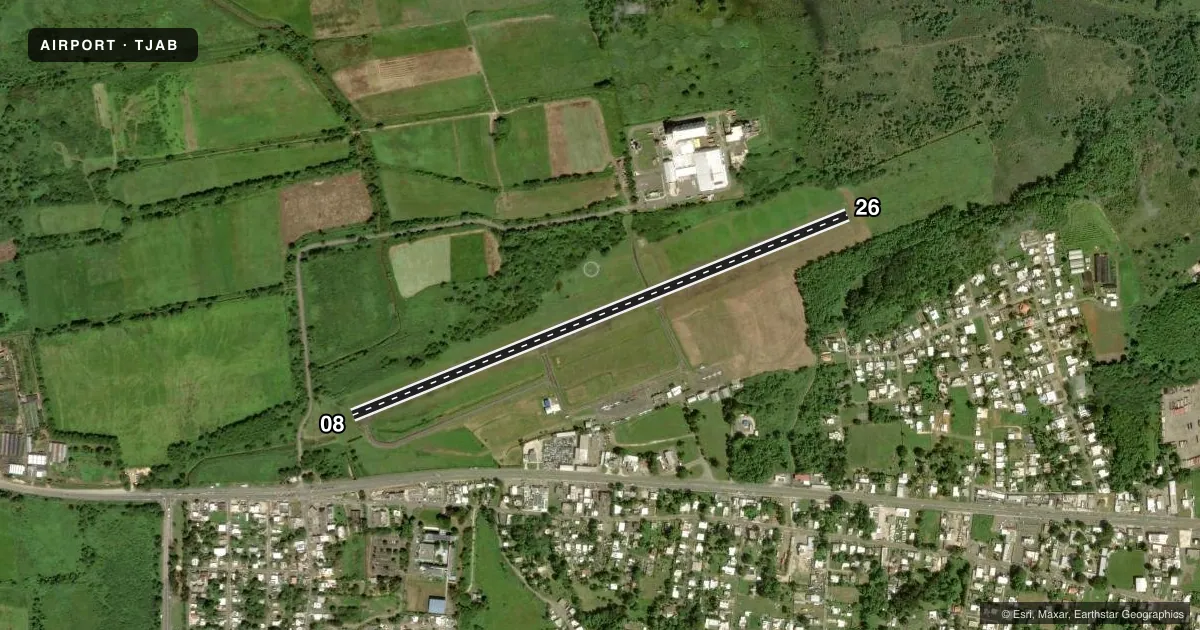
Runways & pattern
Full pagePattern entry · RWY 08
LEFT TRAFFICRunway end performance
| End | TORA | TODA | ASDA | LDA | VGSI | Approach lights | Obstruction |
|---|---|---|---|---|---|---|---|
| 08 | — | — | — | — | — | — | 35', trees, 442' from thr, 150' R of cntrln, slope 6 |
| 26 | — | — | — | — | — | — | 20', trees, 485' from thr, 125' R of cntrln, slope 14 |
Declared distances in feet. TORA = takeoff run available, TODA = takeoff distance, ASDA = accelerate-stop, LDA = landing distance.
Airport sketch
Runways drawn to scale from FAA survey coordinates, rendered over satellite imagery. Not for navigation.
Approaches & charts
Services on the field
Fuel grades, oxygen, maintenance, ramp storage and lighting — as declared to the FAA by the airport operator.
Fuel & services
- Fuel
- Not available
- Oxygen (bottled)
- Not available
- Oxygen (bulk)
- Not available
- Airframe repair
- Not available
- Power plant repair
- Not available
- Other services
- PAJA
Ramp & ground
- Transient storage
- Tie-down
- Landing fee
- Yes
- Customs
- Not available
- Lighting schedule
- SS-SR
- Beacon schedule
- SS-SR
- Beacon
- White / Green (civil land)(WG)
- Wind indicator
- Lighted
- Segmented circle
- Yes
Fuel & FBOs
Cheapest 100LL and Jet A on the field and nearby. Always confirm with the FBO before taxi.
Airport notes
Surface conditions, obstructions, local procedures, lighting outages and other notes published with each FAA cycle.
General notes
- SECURITY GUARD ON SITE AFTR ATND HRS.
- MILITARY HELICOPTER OPERATIONS.
- FOR CD CTC SAN JUAN CERAP AT 787-253-8664/8665
Runway surface & condition
- 08/26PCR VALUE: 27/F/C/X/T
Other notes
- ESTABD PRIOR TO 1951.
- LDG FEE FOR ALL ACFT.
- 1EXCEPT MAJ. HOL.
VFR map & nearby airports
VFR sectional. Tap any ICAO chip to open that airport.
Key facts · TJAB
Answer card- ICAO
- TJAB
- Name
- ANTONIO/NERY/JUARBE POL
- Location
- ARECIBO, PUERTO RICO
- Elevation
- 20.5 ft MSL
- Traffic pattern altitude
- 1,020.5 ft MSL (1,000 AGL)
- Control tower
- Non-towered (use CTAF)
- Total runways
- 1
- Longest runway
- 08/26 · 3,963 ft
- Published ILS approaches
- 0
- Published frequencies
- 2
- Magnetic variation
- 10°
- Current flight rules
- VFR
- Current wind
- 090° at 13 kt
- Favored runway now
- RWY 08
Antonio/Nery/Juarbe Pol is in Arecibo, Puerto Rico. The field elevation is 20.5 ft MSL. It has one runway, 08/26, which is 3,963 ft long with asphalt pavement. The airport is not towered. CTAF and UNICOM are both 122.8. No ILS approaches are published here.
Pattern altitude is not published. Use 1,000 ft AGL for light piston operations unless the current Chart Supplement says otherwise. The airport sits close to sea level, so density altitude is usually less of a factor than on higher fields. Still, coastal weather and local winds can change the picture fast. Check the current Chart Supplement and the airport operator if you need the latest operational details.
Published remarks say clearance delivery is handled through San Juan CERAP by phone. A landing fee is required for all aircraft except major holidays. Military helicopter operations occur after sunset. Skydiving activity also occurs here. The runway pavement classification rating for 08/26 is 27/F/C/X/T. There are no on-field FBOs listed, so contact the airport operator directly or call the field on CTAF or UNICOM for current fuel and service availability before you go.