METAR & TAF TJSJ
Current METAR
Observed 08:56Z
TJSJ 270856Z 00000KT 10SM FEW024 FEW032 27/23 A3002
- Wind
- 000° @ 0 kt
- Visibility
- 10 SM
- Temp / Dew
- 27°C / 23°C
- Altimeter
- 30.02 inHg
- Clouds
- FEW
- Density alt
- 1,328 ft
- Ceiling
- Unlimited
- Rules
- VFR
Airport info & contacts
Manager on record, flight service, ARTCC, attendance schedule and pattern altitude — published by the FAA and refreshed every 28 days.
Location
- From city
- 3 NM SE
- VFR sectional
- PUERTO RICO-VIRGIN ISLANDS
- ARTCC
- ZSU · SAN JUAN
- NOTAM facility
- TJSJ (NOTAM-D)
Airport manager
- Name
- MR. JORGE HERNANDEZ
- Phone
- (787) 289-7240
- Address
- P. O. BOX 38085, SAN JUAN PR 00937-1085
Flight service · Hours
- FSS SJU
- SAN JUAN1-800-WX-BRIEF
- Attendance
- ALL
Frequencies
Tap any row to copy the frequency to your clipboard.
Runways & pattern
Full pagePattern entry · RWY 08
RIGHT TRAFFIC| Runway | Heading (°M) | Length | Surface | Traffic |
|---|---|---|---|---|
| 08/26 | 56° / 236° | 10,400 ft | ASPH | 08 R |
| 10/28 | 79° / 259° | 8,016 ft | CONC | 10 R |
Runway end performance
| End | TORA | TODA | ASDA | LDA | VGSI | Approach lights | Obstruction |
|---|---|---|---|---|---|---|---|
| 08 | 10,400' | 10,400' | 9,784' | 9,384' | PAPI 4-box left(3°) | MALSR | 59', tree, 2675' from thr, 300' R of cntrln, slope 42 |
| 26 | 10,400' | 10,400' | 10,308' | 9,908' | — | — | 72', tree, 2600' from thr, 800' R of cntrln, slope 33 |
| 10 | 8,016' | 8,016' | 8,016' | 8,016' | PAPI 4-box left(3°) | MALSR | 50', tree, 2200' from thr, 300' R of cntrln, slope 40 |
| 28 | 8,016' | 8,016' | 8,016' | 8,016' | PAPI 4-box left(3°) | — | 24', trees, 1000' from thr, slope 33 |
Declared distances in feet. TORA = takeoff run available, TODA = takeoff distance, ASDA = accelerate-stop, LDA = landing distance.
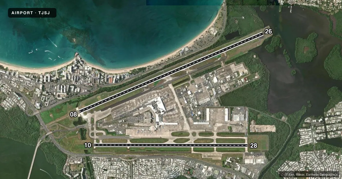
Airport sketch
Runways drawn to scale from FAA survey coordinates, rendered over satellite imagery. Not for navigation.
Approaches & charts
ILS · 2
Services on the field
Fuel grades, oxygen, maintenance, ramp storage and lighting — as declared to the FAA by the airport operator.
Fuel & services
- Fuel
- 100A+A++
- Oxygen (bottled)
- Not available
- Oxygen (bulk)
- Not available
- Airframe repair
- Major
- Power plant repair
- Major
- Other services
- AFRT,CARGO,CHTR
Ramp & ground
- Transient storage
- Hangar
- Landing fee
- Yes
- Customs
- Not available
- Lighting schedule
- SS-SR
- Beacon schedule
- SS-SR
- Beacon
- White / Green (civil land)(WG)
- Wind indicator
- Lighted
- Segmented circle
- No
Fuel & FBOs
Cheapest 100LL and Jet A on the field and nearby. Always confirm with the FBO before taxi.
Airport notes
Surface conditions, obstructions, local procedures, lighting outages and other notes published with each FAA cycle.
General notes
- APRON 12 AVBL FOR GA ACFT ONLY.
- ANG MILITARY APRON - OFFL BUS. NO OVNGT PRKG ALLOWED. OPR 1130-2000Z MON-FRI, CLSD WKEND AND HOL. PPR DSN 740-9629, C787-253-7629. ALL TRAN ACFT CTC COMD POST UHF 235.0, 20 MIN PRIOR TO LDG AND PRIOR TO ENG START.
- TWY J BTN J1 AND J5 (NOT INCLUDING J5) CLSD TO ACFT WITH GREATER THAN 118 FT WINGSPAN.
- ENGINE RUNUPS PROHIBITED ON GATES AREA.
- ACFT 180 TURNS ON TWYS REQUIRES OPS COORDINATIONS.
- FBO/GROUND HANDLER MUST SUBMIT 72 HRS PPR FOR ALL MIL ACFT TO: CCO@AEROSTARAIRPORTS.COM OR BY PHONE TO: 787-253-0979
- ALL PVT AND CORPORATE AIRCRAFT MUST CONTACT ARPT OPS, BEFORE ARRIVAL, FOR FBOS & GROUND HANDLING INFO AT 787-253-0979.
- MILITARY: ANG: INBD ACFT ORIGINATING FR OCONUS WITH A PPR FOR MUNIZ ANGB APN MUST CLEAR CUSTOMS AND BORDER PROTECTION AT CIV SIDE. PRIOR COORD MUST BE MADE WITH ANG AMOPS, FONE 740-9629 AT LEAST ONE BUS DAY PRIOR TO ARRIVAL.
- HI VEHICLE ACTIVITY ADJ TO AND XG TWY N DURG DAY/ NGT OPNS.
Runway surface & condition
- 08/26PCR VALUE: 888/R/B/W/T
- 10/28PCR VALUE: 1050/R/B/W/T
Approach & departure obstructions
- 08RWY 8 PAPI UNUSBL BYD 8 DEGS L AND R OF CNTRL.
Other notes
- 08/26RWY 08 FST 680 FT CONC.
VFR map & nearby airports
VFR sectional. Tap any ICAO chip to open that airport.
Key facts · TJSJ
Answer card- ICAO
- TJSJ
- Name
- LUIS MUNOZ MARIN INTL
- Location
- SAN JUAN, PUERTO RICO
- Elevation
- 9.6 ft MSL
- Traffic pattern altitude
- 1,009.6 ft MSL (1,000 AGL)
- Control tower
- Towered · 24
- Total runways
- 2
- Longest runway
- 08/26 · 10,400 ft
- Published ILS approaches
- 2
- Published frequencies
- 17
- Magnetic variation
- 11°
- Current flight rules
- VFR
- Current wind
- 000° at 0 kt
- Favored runway now
- –
Luis Munoz Marin Intl sits in San Juan, Puerto Rico. Field elevation is 9.6 ft MSL. The airport has 2 runways. The longest is 10,400 ft on runway 08/26. The tower is open 24 hours. Two ILS approaches are published. They serve runway ends 08 and 10.
Pattern altitude is not published in the facts. Use the standard 1,000 ft AGL for light piston operations unless the current Chart Supplement says otherwise. The field is in Class C airspace. Expect busy traffic and close coordination with ATC.
On the field, Airport Aviation Services and Jet Aviation San Juan both carry AVGAS 100LL, JET A and JET A PRIST. Call ahead if you need current handling details. The published remarks also flag heavy vehicle activity near taxiway N during day and night operations. Runway 08 has a fast 680 ft concrete surface. Runway 08 PAPI is unusable beyond 8 degrees left or right of center. Private and corporate aircraft should contact airport operations before arrival for FBO and ground handling information. Military apron use has special restrictions. Check the current Chart Supplement and coordinate early if that applies to your flight.