METAR & TAF PALB
PALB does not publish a METAR.
Showing the nearest reporting station: PAKH (AKHIOK) · 36.4 NM away. Conditions at PALB may differ.
METAR · PAKH
Observed 08:56Z
PAKH 280856Z AUTO 25008KT 10SM OVC021 09/07 A3018 RMK AO2 SLP221 6//// T00890067 401330089 51006 PNO $
- Wind
- 250° @ 8 kt
- Visibility
- 10 SM
- Temp / Dew
- 9°C / 7°C
- Altimeter
- 30.18 inHg
- Clouds
- OVC
- Density alt
- -935 ft
- Ceiling
- 2,100 ft AGL
- Rules
- MVFR
Airport info & contacts
Manager on record, flight service, ARTCC, attendance schedule and pattern altitude — published by the FAA and refreshed every 28 days.
Location
- From city
- 0 NM SE
- VFR sectional
- KODIAK
- ARTCC
- ZAN · ANCHORAGE
- NOTAM facility
- ENA (NOTAM-D)
Airport manager
- Name
- CLARK YATSIK
- Phone
- 907-487-4952
- Address
- 1500 ANTON LARSON RD., KODIAK AK 99615
Flight service · Hours
- FSS ENA
- KENAI907-283-72111-866-864-1737
- Attendance
- Unattended
Frequencies
Tap any row to copy the frequency to your clipboard.
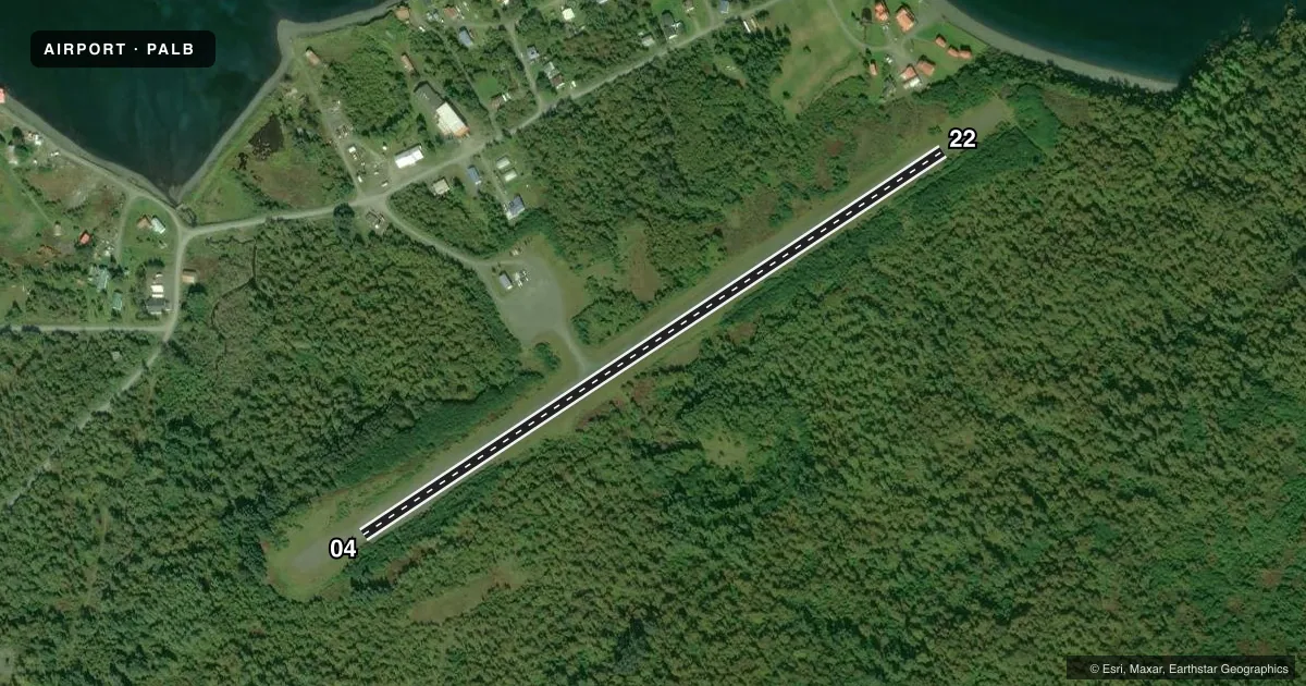
Runways & pattern
Full pagePattern entry · RWY 22
LEFT TRAFFICRunway end performance
| End | TORA | TODA | ASDA | LDA | VGSI | Approach lights | Obstruction |
|---|---|---|---|---|---|---|---|
| 04 | — | — | — | — | — | — | 7', brush, 0' from thr, 60' R of cntrln, slope 1 |
| 22 | — | — | — | — | — | — | 10', brush, 0' from thr, 70' R of cntrln, slope 0 |
Declared distances in feet. TORA = takeoff run available, TODA = takeoff distance, ASDA = accelerate-stop, LDA = landing distance.
Airport sketch
Runways drawn to scale from FAA survey coordinates, rendered over satellite imagery. Not for navigation.
Approaches & charts
Services on the field
Fuel grades, oxygen, maintenance, ramp storage and lighting — as declared to the FAA by the airport operator.
Fuel & services
- Fuel
- Not available
- Oxygen (bottled)
- Not available
- Oxygen (bulk)
- Not available
- Airframe repair
- Not available
- Power plant repair
- Not available
Ramp & ground
- Transient storage
- Not published
- Landing fee
- No fee published
- Customs
- Not available
- Lighting schedule
- SEE RMK
- Beacon schedule
- SEE RMK
- Beacon
- White / Green (civil land)(WG)
- Wind indicator
- Yes
- Segmented circle
- Yes
Fuel & FBOs
Cheapest 100LL and Jet A on the field and nearby. Always confirm with the FBO before taxi.
Airport notes
Surface conditions, obstructions, local procedures, lighting outages and other notes published with each FAA cycle.
General notes
- RY CONDITION NOT MONITORED; RCMD VISUAL INSPECTION PRIOR TO USING.
- WX CAMERA AVBL ON INTERNET AT HTTPS://WEATHERCAMS.FAA.GOV
- LOOSE 3 IN TO 6 IN ROCKS ON SE RY EDGE FULL LENGTH.
- RY 04 OVRN SOFT WITH DEEP RUTS.
Lighting notes
- ACTVT ROTG BCN - CTAF.
- ACTVT MIRL RY 04/22 - CTAF.
Approach & departure obstructions
- 04RYS 04 & 22 THLD MKD WITH LIGHTS. PLASTIC REFLECTORS, AND THLD PANELS.
Other notes
- ALEUTIAN EAST BOROUGH.
- 04/22SLOPES DOWN TOWARD MIDPOINT.
VFR map & nearby airports
VFR sectional. Tap any ICAO chip to open that airport.
Key facts · PALB
Answer card- ICAO
- PALB
- Name
- LARSEN BAY
- Location
- LARSEN BAY, ALASKA
- Elevation
- 86.7 ft MSL
- Traffic pattern altitude
- 1,086.7 ft MSL (1,000 AGL)
- Control tower
- Non-towered (use CTAF)
- Total runways
- 1
- Longest runway
- 04/22 · 2,690 ft
- Published ILS approaches
- 0
- Published frequencies
- 1
- Magnetic variation
- 21°
- Current flight rules
- MVFR
- Current wind
- 250° at 8 kt
- Favored runway now
- RWY 22
Larsen Bay Airport sits in Larsen Bay, Alaska in the Aleutian East Borough. Field elevation is 86.7 ft MSL. The airport has one runway. Runway 04/22 is 2,690 ft long and gravel. No tower is published here. CTAF is 122.8.
No ILS approaches are published. Pattern altitude is not published, so use the current FAA Chart Supplement and local traffic calls before arrival. The runway is marked at both thresholds with lights, plastic reflectors and threshold panels. Medium intensity runway lights on 04/22 are activated by CTAF. The rotating beacon is also CTAF-activated.
This is a field where a visual inspection matters. Runway condition is not monitored. The published remarks also note soft overrun on runway 04 with deep ruts. Loose 3 inch to 6 inch rocks are reported along the southeast runway edge for the full length. The runway slopes down toward the midpoint. That makes a careful taxi and landing plan important, especially in changing light or after weather. No on-field FBOs are listed. Verify fuel and services with the airport operator or by calling the field before you go. Check the current FAA Chart Supplement for any published restrictions before flying in.