METAR & TAF 6R7
6R7 does not publish a METAR.
Showing the nearest reporting station: PAKH (AKHIOK) · 34.2 NM away. Conditions at 6R7 may differ.
METAR · PAKH
Observed 08:56Z
PAKH 280856Z AUTO 25008KT 10SM OVC021 09/07 A3018 RMK AO2 SLP221 6//// T00890067 401330089 51006 PNO $
- Wind
- 250° @ 8 kt
- Visibility
- 10 SM
- Temp / Dew
- 9°C / 7°C
- Altimeter
- 30.18 inHg
- Clouds
- OVC
- Density alt
- -974 ft
- Ceiling
- 2,100 ft AGL
- Rules
- MVFR
Airport info & contacts
Manager on record, flight service, ARTCC, attendance schedule and pattern altitude — published by the FAA and refreshed every 28 days.
Location
- From city
- 2 NM NNE
- VFR sectional
- KODIAK
- ARTCC
- ZAN · ANCHORAGE
- NOTAM facility
- ENA (NOTAM-D)
Airport manager
- Name
- CLARK YATSIK
- Phone
- 907-487-4952
- Address
- 1500 ANTON LARSEN RD., KODIAK AK 99615
Flight service · Hours
- FSS ENA
- KENAI907-283-72111-866-864-1737
- Attendance
- Unattended
Frequencies
Tap any row to copy the frequency to your clipboard.
Runways & pattern
Full pagePattern entry · RWY 21
LEFT TRAFFICRunway end performance
| End | TORA | TODA | ASDA | LDA | VGSI | Approach lights | Obstruction |
|---|---|---|---|---|---|---|---|
| 03 | — | — | — | — | — | — | 10', brush, 80' from thr, 92' R of cntrln, slope 8 |
Declared distances in feet. TORA = takeoff run available, TODA = takeoff distance, ASDA = accelerate-stop, LDA = landing distance.
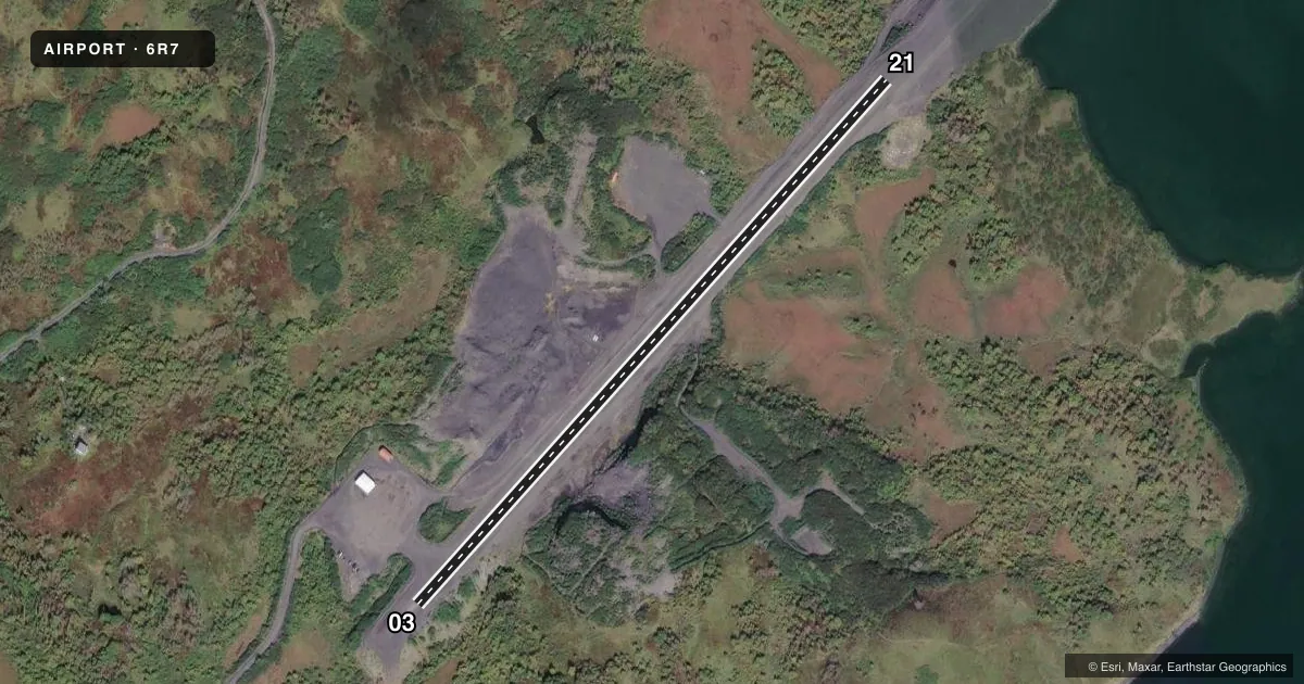
Airport sketch
Runways drawn to scale from FAA survey coordinates, rendered over satellite imagery. Not for navigation.
Approaches & charts
Services on the field
Fuel grades, oxygen, maintenance, ramp storage and lighting — as declared to the FAA by the airport operator.
Fuel & services
- Fuel
- Not available
Ramp & ground
- Transient storage
- Not published
- Wind indicator
- Yes
- Segmented circle
- Yes
Fuel & FBOs
Cheapest 100LL and Jet A on the field and nearby. Always confirm with the FBO before taxi.
Airport notes
Surface conditions, obstructions, local procedures, lighting outages and other notes published with each FAA cycle.
General notes
- RWY COND UNMNT; RCMND VISUAL INSP BFR USE.
- WIND UNPREDICTABLE & GUSTY.
- WX CAMERA AVBL ON INTERNET AT HTTPS://WEATHERCAMS.FAA.GOV.
Runway surface & condition
- 03/21RWY CUTS THRU HILL MIDPT.
Approach & departure obstructions
- 21MT 1.4 MI NE; REDUCE SLOPE TO 12:1.
VFR map & nearby airports
VFR sectional. Tap any ICAO chip to open that airport.
Key facts · 6R7
Answer card- ICAO
- 6R7
- Name
- OLD HARBOR
- Location
- OLD HARBOR, ALASKA
- Elevation
- 55 ft MSL
- Traffic pattern altitude
- 1,055 ft MSL (1,000 AGL)
- Control tower
- Non-towered (use CTAF)
- Total runways
- 1
- Longest runway
- 03/21 · 2,750 ft
- Published ILS approaches
- 0
- Published frequencies
- 1
- Magnetic variation
- 21°
- Current flight rules
- MVFR
- Current wind
- 250° at 8 kt
- Favored runway now
- RWY 21
Old Harbor Airport (6R7) is in Old Harbor, Alaska. Field elevation is 55 ft MSL. It has one runway. The longest is 03/21 at 2,750 ft on gravel. There is no control tower. CTAF is 122.8.
No ILS approaches are published here. Pattern altitude is not published, so a standard 1,000 ft AGL pattern is the practical starting point for light piston planning. The runway headings are magnetic. Runway 03/21 sits at 41.7558540561358° and 221.755854056136°.
The published remarks matter here. The runway cuts through a hill at the midpoint. Runway condition is unmonitored, so a visual check before use is smart. Wind is reported as unpredictable and gusty. There is also a mountain 1.4 miles northeast of the field. The Chart Supplement says to reduce slope to 12 to 1 on that side. A weather camera is available online for a current look before departure.
There are no on-field FBOs listed. Plan to verify services with the airport operator or the FBO directly by phone before you go. For a first visit, treat this as a short gravel strip with terrain nearby and changing wind. That means a careful approach, a good surface check and extra attention to climb performance after takeoff.