METAR & TAF PAKH
Current METAR
Observed 08:56Z
PAKH 280856Z AUTO 25008KT 10SM OVC021 09/07 A3018 RMK AO2 SLP221 6//// T00890067 401330089 51006 PNO $
- Wind
- 250° @ 8 kt
- Visibility
- 10 SM
- Temp / Dew
- 9°C / 7°C
- Altimeter
- 30.18 inHg
- Clouds
- OVC
- Density alt
- -987 ft
- Ceiling
- 2,100 ft AGL
- Rules
- MVFR
Airport info & contacts
Manager on record, flight service, ARTCC, attendance schedule and pattern altitude — published by the FAA and refreshed every 28 days.
Location
- From city
- 1 NM SSW
- VFR sectional
- KODIAK
- ARTCC
- ZAN · ANCHORAGE
- NOTAM facility
- AKK (NOTAM-D)
Airport manager
- Name
- CLARK YATSIK
- Phone
- 907-487-4952
- Address
- 1500 ANTON LARSON RD., KODIAK AK 99615
Flight service · Hours
- FSS ENA
- KENAI907-283-72111-866-864-1737
- Attendance
- Unattended
Frequencies
Tap any row to copy the frequency to your clipboard.
Runways & pattern
Full pagePattern entry · RWY 22
LEFT TRAFFICRunway end performance
| End | TORA | TODA | ASDA | LDA | VGSI | Approach lights | Obstruction |
|---|---|---|---|---|---|---|---|
| 04 | — | — | — | — | — | — | 10', brush, 0' from thr, 30' R of cntrln, slope 0 |
| 22 | — | — | — | — | — | — | 10', brush, 0' from thr, 40' R of cntrln, slope 0 |
Declared distances in feet. TORA = takeoff run available, TODA = takeoff distance, ASDA = accelerate-stop, LDA = landing distance.
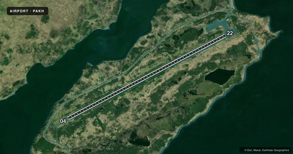
Airport sketch
Runways drawn to scale from FAA survey coordinates, rendered over satellite imagery. Not for navigation.
Approaches & charts
Services on the field
Fuel grades, oxygen, maintenance, ramp storage and lighting — as declared to the FAA by the airport operator.
Fuel & services
- Fuel
- Not available
Ramp & ground
- Transient storage
- Not published
- Landing fee
- No fee published
- Customs
- Not available
- Wind indicator
- Yes
- Segmented circle
- No
Fuel & FBOs
Cheapest 100LL and Jet A on the field and nearby. Always confirm with the FBO before taxi.
Airport notes
Surface conditions, obstructions, local procedures, lighting outages and other notes published with each FAA cycle.
General notes
- RWY COND UNMNT; RCMD VISUAL INSP BFR LNDG.
- WX CAMERA AVBL ON INTERNET AT HTTPS://WEATHERCAMS.FAA.GOV
- BIRDS INVOF ARPT.
Approach & departure obstructions
- 04ORANGE CONES. THR HAS PLASTIC REFLECTIVE MKRS DFCLT TO SEE ON FNA.
- 22ORANGE CONES. THR HAS PLASTIC REFLECTIVE MKRS DFCLT TO SEE ON FNA.
- 04CTL OBSTN EXCEEDS 45 DEG SLOPE.
Other notes
- OWNER907-269-0760
- 04/22NE 1040 FT HAS 2 IN PUDDLED WATER.
VFR map & nearby airports
VFR sectional. Tap any ICAO chip to open that airport.
Key facts · PAKH
Answer card- ICAO
- PAKH
- Name
- AKHIOK
- Location
- AKHIOK, ALASKA
- Elevation
- 44.4 ft MSL
- Traffic pattern altitude
- 1,044.4 ft MSL (1,000 AGL)
- Control tower
- Non-towered (use CTAF)
- Total runways
- 1
- Longest runway
- 04/22 · 3,120 ft
- Published ILS approaches
- 0
- Published frequencies
- 2
- Magnetic variation
- 18°
- Current flight rules
- MVFR
- Current wind
- 250° at 8 kt
- Favored runway now
- RWY 22
Akhiok Airport sits in Akhiok, Alaska. The field elevation is 44.4 ft MSL. It has one runway. Runway 04/22 is 3,120 ft long and gravel. There is no control tower. CTAF and UNICOM are both 122.8.
No ILS approaches are published here. Pattern altitude is not published, so use the standard 1,000 ft AGL pattern unless local procedures or current Chart Supplement remarks say otherwise. That puts the pattern at about 1,044 ft MSL based on the field elevation. Verify before you fly.
There are no on-field FBOs listed. Plan for self-sufficiency on the ground. The published remarks matter here. Birds are in the area. Runway condition is unmonitored, so a visual check before landing is a good idea. The northeast 1,040 ft of the runway has 2 inches of puddled water. Orange cones mark both thresholds. The reflective threshold markers can be hard to see on final. There is also a central obstruction near runway 04 that exceeds a 45 degree slope. That makes a careful stabilized approach important, especially if you are arriving to 04. The airport is in coastal Alaska, so expect weather and surface conditions to change fast. Check the current FAA Chart Supplement and the airport operator before departure.