METAR & TAF PAKY
PAKY does not publish a METAR.
Showing the nearest reporting station: PAKH (AKHIOK) · 38.7 NM away. Conditions at PAKY may differ.
METAR · PAKH
Observed 07:56Z
PAKH 280756Z AUTO 25005KT 10SM OVC019 09/06 A3018 RMK AO2 SLP220 T00890056 PNO $
- Wind
- 250° @ 5 kt
- Visibility
- 10 SM
- Temp / Dew
- 9°C / 6°C
- Altimeter
- 30.18 inHg
- Clouds
- OVC
- Density alt
- -866 ft
- Ceiling
- 1,900 ft AGL
- Rules
- MVFR
Airport info & contacts
Manager on record, flight service, ARTCC, attendance schedule and pattern altitude — published by the FAA and refreshed every 28 days.
Location
- From city
- 1 NM WNW
- VFR sectional
- KODIAK
- ARTCC
- ZAN · ANCHORAGE
- NOTAM facility
- ENA (NOTAM-D)
Airport manager
- Name
- CLARK YATSIK
- Phone
- 907-487-4952
- Address
- 1500 ANTON LARSON RD, KODIAK AK 99615
Flight service · Hours
- FSS ENA
- KENAI907-283-72111-866-864-1737
- Attendance
- Unattended
Frequencies
Tap any row to copy the frequency to your clipboard.
Runways & pattern
Full pagePattern entry · RWY 28
RIGHT TRAFFICRunway end performance
| End | TORA | TODA | ASDA | LDA | VGSI | Approach lights | Obstruction |
|---|---|---|---|---|---|---|---|
| 10 | — | — | — | — | — | — | 6', brush, 0' from thr, 60' R of cntrln, slope 1 |
| 28 | — | — | — | — | — | — | 12', brush, 0' from thr, 60' R of cntrln, slope 1 |
Declared distances in feet. TORA = takeoff run available, TODA = takeoff distance, ASDA = accelerate-stop, LDA = landing distance.
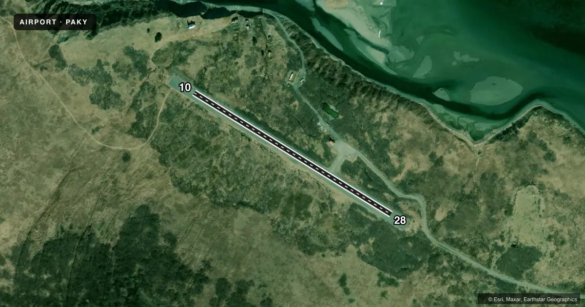
Airport sketch
Runways drawn to scale from FAA survey coordinates, rendered over satellite imagery. Not for navigation.
Approaches & charts
Services on the field
Fuel grades, oxygen, maintenance, ramp storage and lighting — as declared to the FAA by the airport operator.
Fuel & services
- Fuel
- Not available
- Oxygen (bottled)
- Not available
- Oxygen (bulk)
- Not available
- Airframe repair
- Not available
- Power plant repair
- Not available
Ramp & ground
- Transient storage
- Not published
- Landing fee
- No fee published
- Customs
- Not available
- Wind indicator
- Yes
- Segmented circle
- Yes
Fuel & FBOs
Cheapest 100LL and Jet A on the field and nearby. Always confirm with the FBO before taxi.
Airport notes
Surface conditions, obstructions, local procedures, lighting outages and other notes published with each FAA cycle.
General notes
- RY COND NOT MONITORED; RCMD VISUAL INSPECTION PRIOR TO USING.
- WX CAMERA AVBL ON INTERNET AT HTTPS://WEATHERCAMS.FAA.GOV
Approach & departure obstructions
- 10RY 10/28 MKD WITH ORANGE REFLECTIVE CONES.
- 28RY 28 PARTIALLY OVERGROWN.
- 10MOUNTAINS ON S SIDE RY & HILLS +2 MI SE RY 28 THLD.
Other notes
- DAMAGED & OVERGROWN BY ALDERS.
- 10/28DURG SUMMER OPNS, EMBANKMENTS & SAFETY AREAS SOFT.
VFR map & nearby airports
VFR sectional. Tap any ICAO chip to open that airport.
Key facts · PAKY
Answer card- ICAO
- PAKY
- Name
- KARLUK
- Location
- KARLUK, ALASKA
- Elevation
- 141.9 ft MSL
- Traffic pattern altitude
- 1,141.9 ft MSL (1,000 AGL)
- Control tower
- Non-towered (use CTAF)
- Total runways
- 1
- Longest runway
- 10/28 · 2,000 ft
- Published ILS approaches
- 0
- Published frequencies
- 1
- Magnetic variation
- 21°
- Current flight rules
- MVFR
- Current wind
- 250° at 5 kt
- Favored runway now
- RWY 28
Karluk Airport sits in Karluk, Alaska. Field elevation is 141.9 ft MSL. The airport has one runway. Runway 10/28 is 2,000 ft of gravel, so plan for short-field performance and soft-field handling. This is an uncontrolled field with CTAF 122.8. No tower is published. No ILS approaches are published.
The pattern altitude is not published. For light piston operations, use the standard 1,000 ft AGL pattern unless local conditions or the current Chart Supplement say otherwise. The runway environment has a few things worth checking before you commit. Runway 28 is partially overgrown. Runway 10 and 28 are marked with orange reflective cones. The segmented circle marker is damaged and overgrown by alders. Summer embankments and safety areas can be soft. Runway condition is not monitored, so a visual inspection is smart before landing.
Terrain matters here. Mountains are on the south side of the runway. Hills are 2 miles southeast of the Runway 28 threshold. Expect to pay attention to wind, density altitude and go-around planning. There are no on-field FBOs listed. Check with the airport operator or the FBO directly by phone if you need current fuel or service information. A weather camera is available online for a quick look before departure.