METAR & TAF ALZ
ALZ does not publish a METAR.
Showing the nearest reporting station: PAKH (AKHIOK) · 3.3 NM away. Conditions at ALZ may differ.
METAR · PAKH
Observed 10:56Z
PAKH 281056Z AUTO 24006KT 6SM -RA BR SCT008 OVC017 09/08 A3020 RMK AO2 RAB0957E07B53 SLP224 T00890083 PNO $
- Wind
- 240° @ 6 kt
- Visibility
- 6 SM
- Temp / Dew
- 9°C / 8°C
- Altimeter
- 30.20 inHg
- Clouds
- OVC
- Density alt
- -1,067 ft
- Ceiling
- 1,700 ft AGL
- Rules
- MVFR
Airport info & contacts
Manager on record, flight service, ARTCC, attendance schedule and pattern altitude — published by the FAA and refreshed every 28 days.
Location
- From city
- 0 NM S
- VFR sectional
- KODIAK
- ARTCC
- ZAN · ANCHORAGE
- NOTAM facility
- ENA (NOTAM-D)
Airport manager
- Name
- SUE HALLADAY
- Phone
- 907-771-4800
- Address
- PO BOX 70739, SEATTLE WA 98127
Flight service · Hours
- FSS ENA
- KENAI907-283-72111-866-864-1737
- Attendance
- Unattended
Frequencies
Tap any row to copy the frequency to your clipboard.
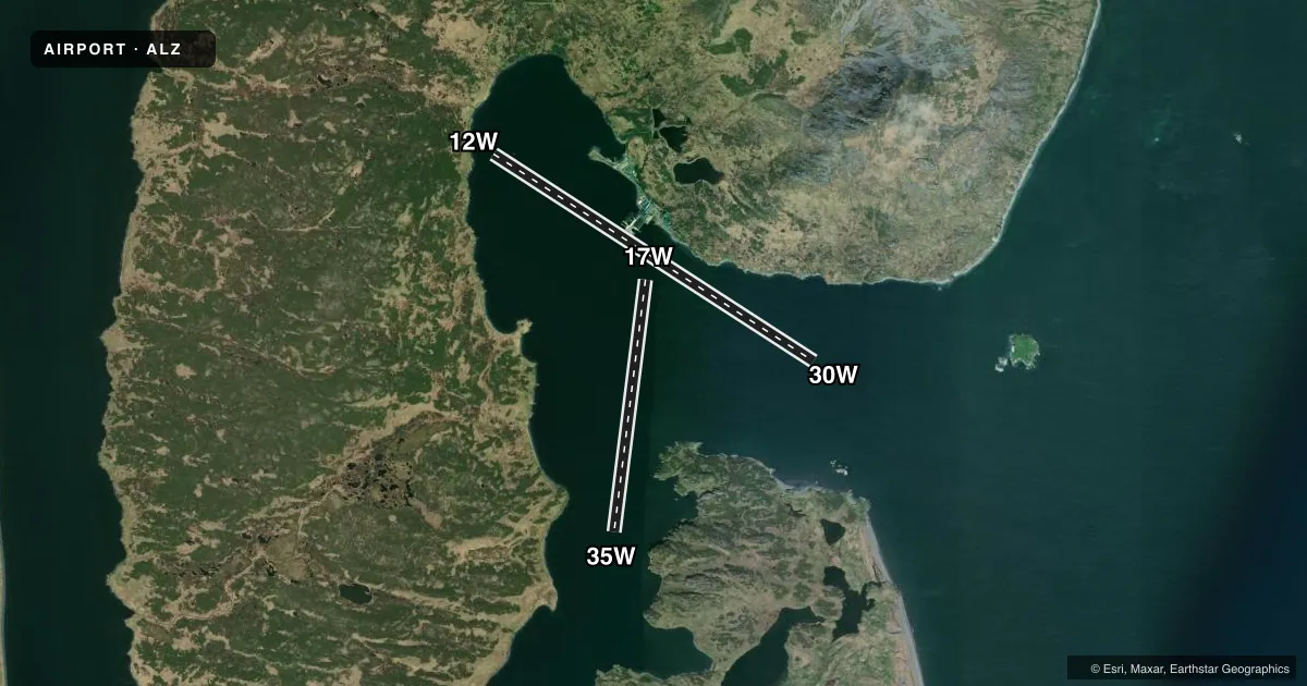
Runways & pattern
Full pagePattern entry · RWY 17W
LEFT TRAFFICAirport sketch
Runways drawn to scale from FAA survey coordinates, rendered over satellite imagery. Not for navigation.
Approaches & charts
Services on the field
Fuel grades, oxygen, maintenance, ramp storage and lighting — as declared to the FAA by the airport operator.
Fuel & services
- Fuel
- Not available
Ramp & ground
- Transient storage
- Not published
- Landing fee
- No fee published
- Customs
- Not available
- Wind indicator
- Yes
- Segmented circle
- No
Fuel & FBOs
Cheapest 100LL and Jet A on the field and nearby. Always confirm with the FBO before taxi.
Airport notes
Surface conditions, obstructions, local procedures, lighting outages and other notes published with each FAA cycle.
General notes
- E-W PVLG WINDS; E WINDS SUBJECT TO SWELLS.
- GRVL BEACHING AREA E OF CANNERY. BEACHING AREA DOCK HAZUS.
- WX CAMERA AVBL ON INTERNET AT HTTPS://WEATHERCAMS.FAA.GOV
- BIRD ACT INVOF ARPT.
- LMTD SUMMER PARA GLDR ACT.
VFR map & nearby airports
VFR sectional. Tap any ICAO chip to open that airport.
Key facts · ALZ
Answer card- ICAO
- ALZ
- Name
- ALITAK
- Location
- LAZY BAY, ALASKA
- Elevation
- 0 ft MSL
- Traffic pattern altitude
- 1,000 ft MSL (1,000 AGL)
- Control tower
- Non-towered (use CTAF)
- Total runways
- 2
- Longest runway
- 12W/30W · 6,000 ft
- Published ILS approaches
- 0
- Published frequencies
- 1
- Magnetic variation
- 21°
- Current flight rules
- MVFR
- Current wind
- 240° at 6 kt
- Favored runway now
- RWY 17W
Alitak (ALZ) sits in Lazy Bay, Alaska. Field elevation is 0 ft MSL. This is a water airport with two runways. The longest is 12W/30W at 6,000 ft. The other is 17W/35W at 4,000 ft. There is no control tower. CTAF is 122.8.
No ILS approaches are published here. Pattern altitude is not published. For a light piston, use the standard 1,000 ft AGL unless the current Chart Supplement says otherwise. With a sea-level field and water operations, keep an eye on wind and swell. The published remarks call out east-west prevailing winds. East winds can bring swells. Bird activity is also noted in the area. There is a gravel beaching area east of the cannery. Dock hazards are mentioned there, so plan your water handling carefully.
No on-field FBOs are listed. Check with the airport operator or the FBO directly by phone before arrival if you need current services. A weather camera is available online for a current look at conditions. Limited summer paraglider activity is also published, so expect some extra traffic in season.