METAR & TAF KWHP
Current METAR
Observed 01:00Z
KWHP 270100Z 12005KT 10SM SKC 34/11 A2991
- Wind
- 120° @ 5 kt
- Visibility
- 10 SM
- Temp / Dew
- 34°C / 11°C
- Altimeter
- 29.91 inHg
- Clouds
- SKC
- Density alt
- 3,536 ft
- Ceiling
- Unlimited
- Rules
- VFR
Airport info & contacts
Manager on record, flight service, ARTCC, attendance schedule and pattern altitude — published by the FAA and refreshed every 28 days.
Location
- From city
- 1 NM E
- VFR sectional
- LOS ANGELES
- ARTCC
- ZLA · LOS ANGELES
- NOTAM facility
- WHP (NOTAM-D)
Airport manager
- Name
- ALVARO ESCOBEDO
- Phone
- 818-896-5271
- Address
- 10000 AIRPARK WAY, PACOIMA CA 91331
Flight service · Hours
- FSS HHR
- HAWTHORNE1-800-WX-BRIEF
- Attendance
- ALL
Frequencies
Tap any row to copy the frequency to your clipboard.
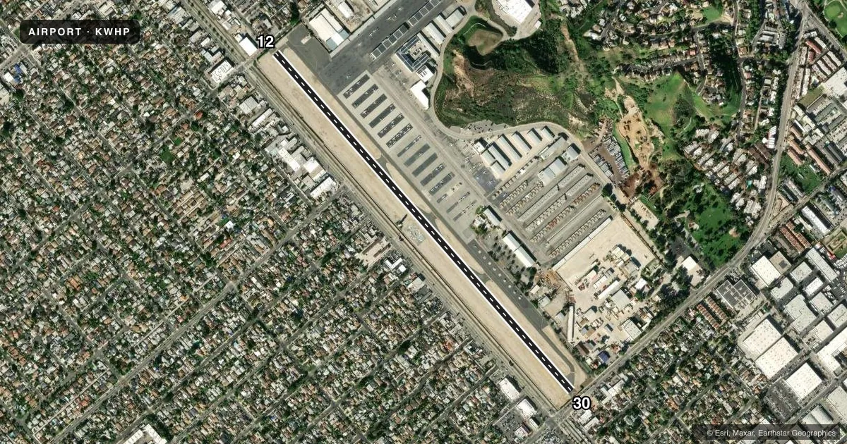
Runways & pattern
Full pagePattern entry · RWY 12
LEFT TRAFFICRunway end performance
| End | TORA | TODA | ASDA | LDA | VGSI | Approach lights | Obstruction |
|---|---|---|---|---|---|---|---|
| 12 | 3,442' | 4,120' | 3,910' | 3,181' | PAPI 2-box right(3.8°) | — | 30', pline, 200' from thr, 45' R of cntrln, slope 0 |
| 30 | 3,191' | 4,120' | 3,940' | 3,462' | PAPI 2-box left(3.8°) | — | 30', pline, 200' from thr, 10' R of cntrln, slope 0 |
Declared distances in feet. TORA = takeoff run available, TODA = takeoff distance, ASDA = accelerate-stop, LDA = landing distance.
Airport sketch
Runways drawn to scale from FAA survey coordinates, rendered over satellite imagery. Not for navigation.
Approaches & charts
Services on the field
Fuel grades, oxygen, maintenance, ramp storage and lighting — as declared to the FAA by the airport operator.
Fuel & services
- Fuel
- 100LLAUL94
- Oxygen (bottled)
- High pressure
- Oxygen (bulk)
- High pressure
- Airframe repair
- Major
- Power plant repair
- Major
- Other services
- AVNCS,CHTR,INSTR,RNTL,SALES,SURV
Ramp & ground
- Transient storage
- Tie-down
- Lighting schedule
- SEE RMK
- Beacon schedule
- SS-SR
- Beacon
- White / Green (civil land)(WG)
- Wind indicator
- Lighted
- Segmented circle
- Yes
Fuel & FBOs
Cheapest 100LL and Jet A on the field and nearby. Always confirm with the FBO before taxi.
Airport notes
Surface conditions, obstructions, local procedures, lighting outages and other notes published with each FAA cycle.
General notes
- HELICOPTER OPNS 2500' MSL (1500' AGL) AND BELOW.
- POWER LINES SW OF RY PENETRATE 7:1 TRANSITIONAL SFC.
- BIRDS ON AND INVOF ARPT.
- (E125) INCLUDES 3 AMPHIBIANS.
- AIRPORT CLOSED TO HELICOPTER TRAINING / PATTERN OPERATIONS 2000-0800.
- DIRT INFIELD AREAS. HELICOPTERS ADVISED TO USE CARE TO PREVENT BLASTING DIRT AND DEBRIS ONTO MOVEMENT AREAS.
- FOR CD WHEN ATCT CLSD CTC SOCAL APCH AT 800-448-3724.
- VOLUNTARY CURFEW IN EFCT. ALL ACFT OPRS, EXCP FOR FLTS RELATED TO EMERG, LIFESAVING, FIREFIGHTING, LAW ENFORCEMENT, GOVT AGENCIES, AND SVCS TO THE PUBLIC SUCH AS NEWS MEDIA, ARE REQD TO AVOID CONDUCTING ACFT ARRS AND DEPS BTN 2200 AND 0600 DAILY.
Lighting notes
- WHEN ATCT CLSD, ARPT LGT OPRS CONSLY.
Approach & departure obstructions
- 12HAS + 6 FT FENCE 60 FT FM EOR AND ROAD 70 FT FM EOR 125 FT L TO R; +12 FT BLDG 135-200 FM FM EOR 20-50 FT L; +24 FT LIGHT STANDARD 140 FT FM EOR 45 FT R.
- 30HAS 35 FT TREES 50 FT FM EOR 110 FT R; +6 FT FENCE 30 FT FM EOR 125 FT L TO R; ROAD 80 FT FM EOR 125 FT L TO R; +30 FT PLINES 160 FT FM EOR 125 FT L TO R; + 20 FT LIGHT 75 FT FM EOR 20 FT L.
- 12PAPI DOES NOT PRVD OBSTN CLNC BYD 5 NM FROM THLD.
- 12APCH RATIO 30:1 TO DSPLCD THLD; APCH RATIO TO DSPLCD THLD OVER 33 FT BLDG 850 FT FM DSPLCD THLD 95 FT R 25:1.
- 30APCH RATIO 22:1 TO DSPLCD THLD; APCH RATIO TO DSPLCD THLD OVER +35 FT TREE 488 FT FM DSPLCD THLD 110 FT R 13:1.
Other notes
- MANAGERASSISTANT AMGR: ERNIE UMANA
- MANAGERAIR TRAFFIC MGR: 818-834-3009.
- OWNERLA COUNTY CTC: JASON MORGAN, 626-300-4600 X4615.
VFR map & nearby airports
VFR sectional. Tap any ICAO chip to open that airport.
Key facts · KWHP
Answer card- ICAO
- KWHP
- Name
- WHITEMAN
- Location
- LOS ANGELES, CALIFORNIA
- Elevation
- 1,003 ft MSL
- Traffic pattern altitude
- 2,003 ft MSL (1,000 AGL)
- Control tower
- Towered · 0800-2000
- Total runways
- 1
- Longest runway
- 12/30 · 4,120 ft
- Published ILS approaches
- 0
- Published frequencies
- 13
- Magnetic variation
- 14°
- Current flight rules
- VFR
- Current wind
- 120° at 5 kt
- Favored runway now
- RWY 12
Whiteman Airport sits in Los Angeles, California. Field elevation is 1,003 ft MSL. The airport has one runway, 12/30, which is 4,120 ft long. The tower is open from 0800 to 2000. No ILS approaches are published here. Pattern altitude is not published, so use the standard 1,000 ft AGL for light piston traffic unless ATC or the current Chart Supplement says otherwise.
Billion Air is on the field. It carries 100LL, Jet A and Jet A Prist. Call them at (818) 454-0985 for current services. The airport sits under SOCAL Class C coverage on the published frequencies. That matters for first-time arrivals because you will want to be set up early. You should also be ready for handoffs.
The published remarks show several close-in obstacles. Runway 12 and 30 both have trees, fences, buildings, roads and light standards near the ends. The 12 side also has displaced-threshold approach considerations. Helicopter operations are limited to 2,500 ft MSL and below. The field has a voluntary curfew. Arrivals and departures should be avoided between 2200 and 0600 unless the flight is emergency, public safety, or another listed exception. When the tower is closed, airport lighting stays on continuously. Dirt infield areas are present, so helicopter pilots should watch for blowing debris.