METAR & TAF KVQQ
Current METAR
Observed 17:50Z
KVQQ 271750Z VRB05KT 10SM BKN046 35/24 A2986
- Wind
- VAR @ 5 kt
- Visibility
- 10 SM
- Temp / Dew
- 35°C / 24°C
- Altimeter
- 29.86 inHg
- Clouds
- BKN
- Density alt
- 2,573 ft
- Ceiling
- 4,600 ft AGL
- Rules
- VFR
Airport info & contacts
Manager on record, flight service, ARTCC, attendance schedule and pattern altitude — published by the FAA and refreshed every 28 days.
Location
- From city
- 0 NM N
- VFR sectional
- JACKSONVILLE
- ARTCC
- ZJX · JACKSONVILLE
- NOTAM facility
- VQQ (NOTAM-D)
Airport manager
- Name
- MATT BOCCHINO
- Phone
- 904-573-1601
- Address
- 13365 SIMPSON WAY, JACKSONVILLE FL 32221-5522
Flight service · Hours
- FSS PIE
- SAINT PETERSBURG1-800-WX-BRIEF
- Attendance
- MON-FRI · 0700-2300
- SAT-SUN · 0700-2100
Frequencies
Tap any row to copy the frequency to your clipboard.
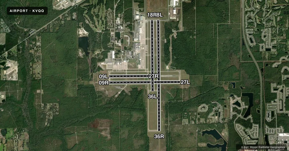
Runways & pattern
Full pagePattern entry · RWY 36R
LEFT TRAFFIC| Runway | Heading (°M) | Length | Surface | Traffic |
|---|---|---|---|---|
| 18L/36RFavored | 175° / 355° | 12,504 ft | ASPH-CONC | Standard L |
| 09R/27L | 85° / 265° | 8,003 ft | ASPH-CONC | Standard L |
| 18R/36L | 174° / 354° | 8,001 ft | ASPH-CONC | Standard L |
| 09L/27R | 85° / 265° | 4,439 ft | ASPH-CONC | Standard L |
Runway end performance
| End | TORA | TODA | ASDA | LDA | VGSI | Approach lights | Obstruction |
|---|---|---|---|---|---|---|---|
| 18L | — | — | — | — | PAPI 4-box left(3°) | — | 74', trees, 3125' from thr, 320' R of cntrln, slope 40 |
| 36R | — | — | — | — | PAPI 4-box left(3°) | MALSR | 87', trees, 4595' from thr, 500' R of cntrln, slope 50 |
| 09R | — | — | — | — | PAPI 4-box left(3°) | MALSR | 76', trees, 2860' from thr, 225' R of cntrln, slope 35 |
| 27L | — | — | — | — | PAPI 4-box left(3°) | — | 50', trees, 1920' from thr, 550' R of cntrln, slope 34 |
| 18R | — | — | — | — | — | — | 79', trees, 3840' from thr, 225' R of cntrln, slope 46 |
| 09L | — | — | — | — | — | — | 74', trees, 2720' from thr, 275' R of cntrln, slope 34 |
Declared distances in feet. TORA = takeoff run available, TODA = takeoff distance, ASDA = accelerate-stop, LDA = landing distance.
Airport sketch
Runways drawn to scale from FAA survey coordinates, rendered over satellite imagery. Not for navigation.
Approaches & charts
ILS · 1
Services on the field
Fuel grades, oxygen, maintenance, ramp storage and lighting — as declared to the FAA by the airport operator.
Fuel & services
- Fuel
- 100LLA1+
- Oxygen (bottled)
- HIGH/LOW
- Oxygen (bulk)
- High pressure
- Airframe repair
- Major
- Power plant repair
- Major
- Other services
- AVNCS,INSTR
Ramp & ground
- Transient storage
- Tie-down
- Lighting schedule
- SEE RMK
- Beacon schedule
- SS-SR
- Beacon
- White / Green (civil land)(WG)
- Wind indicator
- Lighted
- Segmented circle
- No
Fuel & FBOs
Cheapest 100LL and Jet A on the field and nearby. Always confirm with the FBO before taxi.
Airport notes
Surface conditions, obstructions, local procedures, lighting outages and other notes published with each FAA cycle.
General notes
- CTN: DALGT GLDR OPS 6000 FT & BLW; HERLONG RECREATIONAL 5 NM NE.
- MISC: BOEING AEROSPACE SUPPORT CENTER AIR OPS MON-FRI 0700-1800, SAT PPR, CLSD SUN; ALL ARR - 904-317-2438/2425; 15 MIN PRIOR TO LNDG - 123.475 OR 264.65.
- TWY C CLSD AT MIL GATE. TWY M CLSD EXC TO MIL ACFT.
- ARNG: RAMP ACES PPR - D860-7728 OPTION 5; 1300-2130Z++ MON-FRI EXC HOL.
- WILDLIFE INVOF ARPT.
- HOLD SHRT SIGN RWY 9L/27R & 18R/36L UNLGTD.
- 180 DEG TURN ON ASPH PTNS OF RWY BY P-3 OR LRGR NA.
- MIL CARRIER BREAK NA.
- ARNG: MIL ASSETS PPR - C904-573-2300 EXT 1012/1013/1014; TSNT CTC ARNG OPS - 40.90, 148.825 OR 248.2 BFR ENTRY TO PRK RAMP.
- DEP TURNS PRIOR TO DER WO TWR APVL NA.
- GCO AVBL ON FREQ 135.075 - JACKSONVILLE APCH.
- FOR CD WHEN ATCT CLSD, AND UNA VIA GCO, CTC JACKSONVILLE TRACON AT 904-741-0284.
- VTOL OPNS NOT AUTH.
- RWY 18R/36L RSTD TO ACFT WITH WINGSPAN OF LESS THAN 79 FT, EXCLUDING TXY XG.
- AIR TO FBO COMMUNICATIONS (MILLION AIR) AVBL ON 130.925.
- 24 HR PPR FOR ACFT EQUIPPED WITH WEATHER MODIFICATION OR GEOENGINEERING EQPT 904-741-2020
Lighting notes
- WHEN ATCT CLSD ACTVT MALSR RWY 9R & 36R; REIL RWY 18L & 27L; HIRL RWY 18L/36R, 09R/27L - CTAF.
Runway surface & condition
- 09L/27RRSTD TO FIXED WING 12500 LBS & BLW.
Other notes
- AVNCSON CALL.
- 18R/36LLONGL & TRANSVERSE CRACKING BTN INTS.
VFR map & nearby airports
VFR sectional. Tap any ICAO chip to open that airport.
Key facts · KVQQ
Answer card- ICAO
- KVQQ
- Name
- CECIL
- Location
- JACKSONVILLE, FLORIDA
- Elevation
- 79.5 ft MSL
- Traffic pattern altitude
- 1,079.5 ft MSL (1,000 AGL)
- Control tower
- Towered · 0700-2300 MON-FRI, 0700-2100 SAT-SUN.
- Total runways
- 4
- Longest runway
- 18L/36R · 12,504 ft
- Published ILS approaches
- 1
- Published frequencies
- 10
- Magnetic variation
- 5°
- Current flight rules
- VFR
- Current wind
- 000° at 5 kt
- Favored runway now
- RWY 36R
CECIL is in Jacksonville, Florida. The field elevation is 79.5 ft MSL. It has four asphalt-concrete runways. The longest is 12,504 ft on 18L/36R. The tower is open 0700-2300 Monday through Friday. Weekend hours are 0700-2100. There is 1 ILS approach. It serves runway 36R.
Pattern altitude is not published in the facts. Use the standard 1,000 ft AGL for light piston traffic unless ATC or the current Chart Supplement says otherwise. Million Air is on the field. It carries 100LL and Jet A Prist. Air to FBO communications with Million Air are available on 130.925. Ramp access needs prior permission. Call ahead before you plan to park.
A few operational items matter here. Runway 18R/36L is limited to aircraft with wingspan under 79 ft. Cracking is reported on 18R/36L between intersections. Wildlife is also noted in the airport area. When the tower is closed, use the published lighting procedures and coordinate with Jacksonville TRACON for clearance delivery if you are arriving through the ground communications outlet. This is a busy controlled field in the Jacksonville area. Verify any current restrictions in the current FAA Chart Supplement before you go.