METAR & TAF KVLD
Current METAR
Observed 15:53Z
KVLD 271553Z 34007KT 10SM SCT037 SCT050 33/24 A2988 RMK AO2 SLP124 T03330244 $
- Wind
- 340° @ 7 kt
- Visibility
- 10 SM
- Temp / Dew
- 33°C / 24°C
- Altimeter
- 29.88 inHg
- Clouds
- SCT
- Density alt
- 2,461 ft
- Ceiling
- Unlimited
- Rules
- VFR
Airport info & contacts
Manager on record, flight service, ARTCC, attendance schedule and pattern altitude — published by the FAA and refreshed every 28 days.
Location
- From city
- 3 NM S
- VFR sectional
- JACKSONVILLE
- ARTCC
- ZJX · JACKSONVILLE
- NOTAM facility
- VLD (NOTAM-D)
Airport manager
- Name
- TIM HOOD
- Phone
- 229-333-1833
- Address
- 1750 AIRPORT RD, SUITE 1, VALDOSTA GA 31601
Flight service · Hours
- FSS MCN
- MACON1-800-WX-BRIEF
- Attendance
- 0600-2200
Frequencies
Tap any row to copy the frequency to your clipboard.
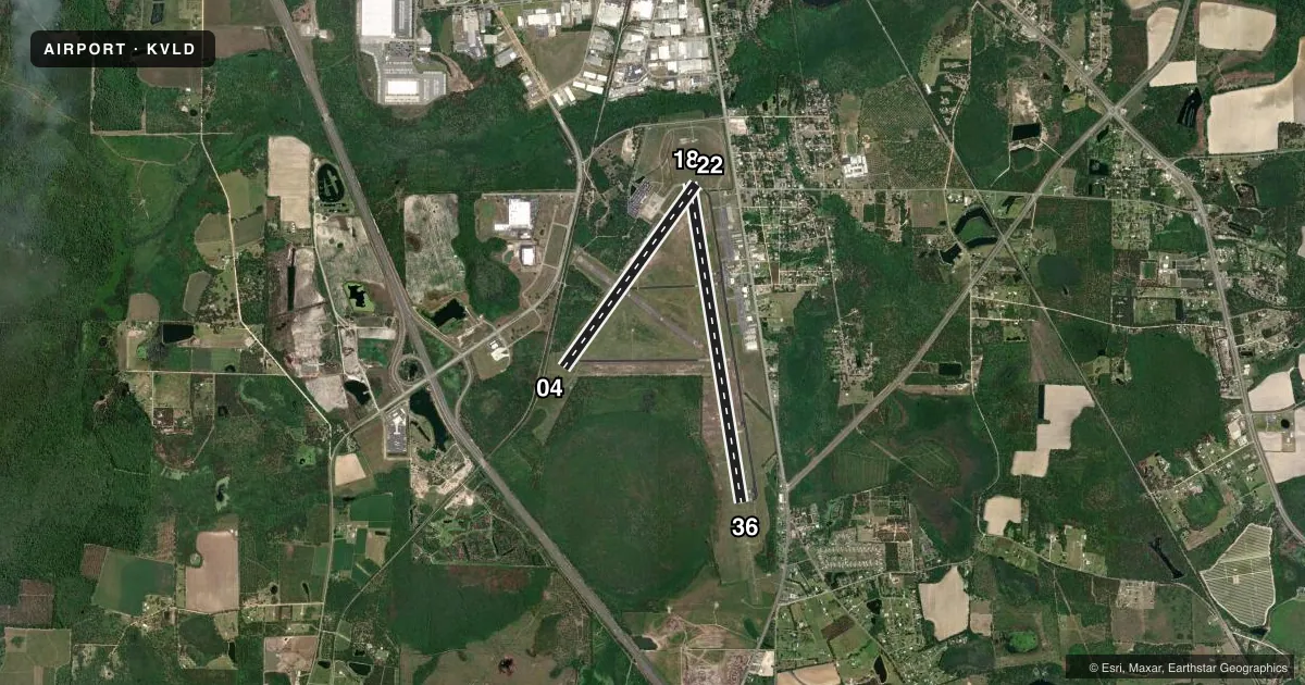
Runways & pattern
Full pagePattern entry · RWY 36
LEFT TRAFFIC| Runway | Heading (°M) | Length | Surface | Traffic |
|---|---|---|---|---|
| 18/36Favored | 166° / 346° | 8,003 ft | ASPH | Standard L |
| 04/22 | 31° / 211° | 5,598 ft | ASPH | Standard L |
Runway end performance
| End | TORA | TODA | ASDA | LDA | VGSI | Approach lights | Obstruction |
|---|---|---|---|---|---|---|---|
| 18 | 8,002' | 8,002' | 8,002' | 8,002' | PAPI 4-box left(3°) | — | 55', trees, 1875' from thr, 60' R of cntrln, slope 25 |
| 36 | 8,002' | 8,002' | 8,002' | 8,002' | PAPI 4-box left(3°) | MALSR | 56', trees, 3000' from thr, 875' R of cntrln, slope 50 |
| 04 | 5,598' | 5,598' | 5,598' | 5,598' | PAPI 4-box left(3.25°) | — | 7', trees, 300' from thr, 70' R of cntrln, slope 14 |
| 22 | 5,598' | 5,598' | 5,598' | 5,598' | PAPI 4-box left(3.25°) | — | 48', trees, 1175' from thr, 320' R of cntrln, slope 20 |
Declared distances in feet. TORA = takeoff run available, TODA = takeoff distance, ASDA = accelerate-stop, LDA = landing distance.
Airport sketch
Runways drawn to scale from FAA survey coordinates, rendered over satellite imagery. Not for navigation.
Approaches & charts
ILS · 1
Services on the field
Fuel grades, oxygen, maintenance, ramp storage and lighting — as declared to the FAA by the airport operator.
Fuel & services
- Fuel
- 100LLA1+
- Oxygen (bottled)
- Not available
- Oxygen (bulk)
- Not available
- Airframe repair
- Major
- Power plant repair
- Major
- Other services
- INSTR,RNTL
Ramp & ground
- Transient storage
- Tie-down
- Hangar
- Landing fee
- No fee published
- Customs
- Not available
- Lighting schedule
- SEE RMK
- Beacon schedule
- SS-SR
- Beacon
- White / Green (civil land)(WG)
- Wind indicator
- Lighted
- Segmented circle
- Yes
Fuel & FBOs
Cheapest 100LL and Jet A on the field and nearby. Always confirm with the FBO before taxi.
Airport notes
Surface conditions, obstructions, local procedures, lighting outages and other notes published with each FAA cycle.
General notes
- RWY 04/22 HAS 10 FT PAVED SHOULDERS WITH VEGETATION.
- PILOTS MUST SUP OWN TIE-DOWN ROPES.
- PILOTS CONDUCTING EFVS OPS; BE AWARE LED ALS IN USE RWY 36.
Lighting notes
- WHEN ATCT CLSD ACTVT MALSR RWY 36; REIL RWY 18; PAPI RWY 18 & 36; HIRL RWY 18/36 - CTAF. REIL RWY 04/22; PAPI RWY 04 & 22; MIRL RWY 04/22 UNAVBL WHEN ATCT CLSD.
Runway surface & condition
- 04/22PCR VALUE: 290/F/B/X/T
- 18/36PCR VALUE: 400/F/B/X/T
Approach & departure obstructions
- 04PAPI UNUSBL BYD 7 DEG LEFT OF CNTRLN.
Other notes
- CLSD TO UNSKED ACR OPNS WITH MORE THAN 30 PSGR SEATS EXCP 24 HR PPR CALL AMGR 229-333-1833.
- 1CONTACT FBO 229-242-3175.
VFR map & nearby airports
VFR sectional. Tap any ICAO chip to open that airport.
Key facts · KVLD
Answer card- ICAO
- KVLD
- Name
- VALDOSTA RGNL
- Location
- VALDOSTA, GEORGIA
- Elevation
- 203.1 ft MSL
- Traffic pattern altitude
- 1,203.1 ft MSL (1,000 AGL)
- Control tower
- Towered · 0700-2200
- Total runways
- 2
- Longest runway
- 18/36 · 8,003 ft
- Published ILS approaches
- 1
- Published frequencies
- 6
- Magnetic variation
- 5°
- Current flight rules
- VFR
- Current wind
- 340° at 7 kt
- Favored runway now
- RWY 36
Valdosta Rgnl is in Valdosta, Georgia. Field elevation is 203.1 ft MSL. The airport has two asphalt runways. The longest is runway 18/36 at 8,003 ft. Runway 04/22 is 5,598 ft. The tower is open daily from 0700 to 2200. One ILS approach is published for runway 36. Pattern altitude is not published in the facts, so use the standard 1,000 ft AGL for light piston traffic unless the current Chart Supplement says otherwise.
Valdosta Flying Service is on the field. It carries AVGAS 100LL and Jet A. The airport remarks also say pilots must supply their own tie-down ropes. Runway 04/22 has paved shoulders with vegetation. That is worth keeping in mind if you are planning to use that strip.
When the tower is closed, runway lighting and approach lighting for runway 36 are activated on CTAF. Lighting for runway 04/22 is also available. Medium intensity runway lights for 04/22 are unavailable after tower hours. The published remarks also note that unscheduled aircraft operations with more than 30 passenger seats need 24-hour prior permission. First-time visitors should also plan for a controlled field with active tower procedures during the day. Check the current Chart Supplement before departure for any updates to local procedures or operating limits.