METAR & TAF KVCV
Current METAR
Observed 13:35Z
KVCV 271335Z AUTO 20006KT 10SM CLR 21/11 A3005 RMK AO2
- Wind
- 200° @ 6 kt
- Visibility
- 10 SM
- Temp / Dew
- 21°C / 11°C
- Altimeter
- 30.05 inHg
- Clouds
- CLR
- Density alt
- 4,137 ft
- Ceiling
- Unlimited
- Rules
- VFR
Airport info & contacts
Manager on record, flight service, ARTCC, attendance schedule and pattern altitude — published by the FAA and refreshed every 28 days.
Location
- From city
- 5 NM NW
- VFR sectional
- LOS ANGELES
- ARTCC
- ZLA · LOS ANGELES
- NOTAM facility
- VCV (NOTAM-D)
Airport manager
- Name
- JAMES MURAWSKI
- Phone
- 760-243-1915
- Address
- SO CAL LOGISTICS AIRPORT AUTHORITY, 18374 PHANTOM WEST, VICTORVILLE CA 92394
Flight service · Hours
- FSS RAL
- RIVERSIDE1-800-WX-BRIEF
- Attendance
- 0600-2000
Frequencies
Tap any row to copy the frequency to your clipboard.
Runways & pattern
Full pagePattern entry · RWY 17
RIGHT TRAFFIC| Runway | Heading (°M) | Length | Surface | Traffic |
|---|---|---|---|---|
| 17/35Favored | 166° / 346° | 13,052 ft | ASPH-CONC | 17 R |
| 03/21 | 31° / 211° | 9,138 ft | ASPH-CONC | 03 R |
Runway end performance
| End | TORA | TODA | ASDA | LDA | VGSI | Approach lights | Obstruction |
|---|---|---|---|---|---|---|---|
| 17 | 13,052' | 13,052' | 13,052' | 13,052' | PAPI 4-box left(3°) | — | — |
| 35 | 13,052' | 13,052' | 13,052' | 13,052' | PAPI 4-box left(3°) | — | — |
| 03 | 9,138' | 9,138' | 9,138' | 9,138' | PAPI 4-box left(3°) | — | — |
| 21 | 9,138' | 9,138' | 9,138' | 9,138' | PAPI 4-box left(3°) | — | — |
Declared distances in feet. TORA = takeoff run available, TODA = takeoff distance, ASDA = accelerate-stop, LDA = landing distance.
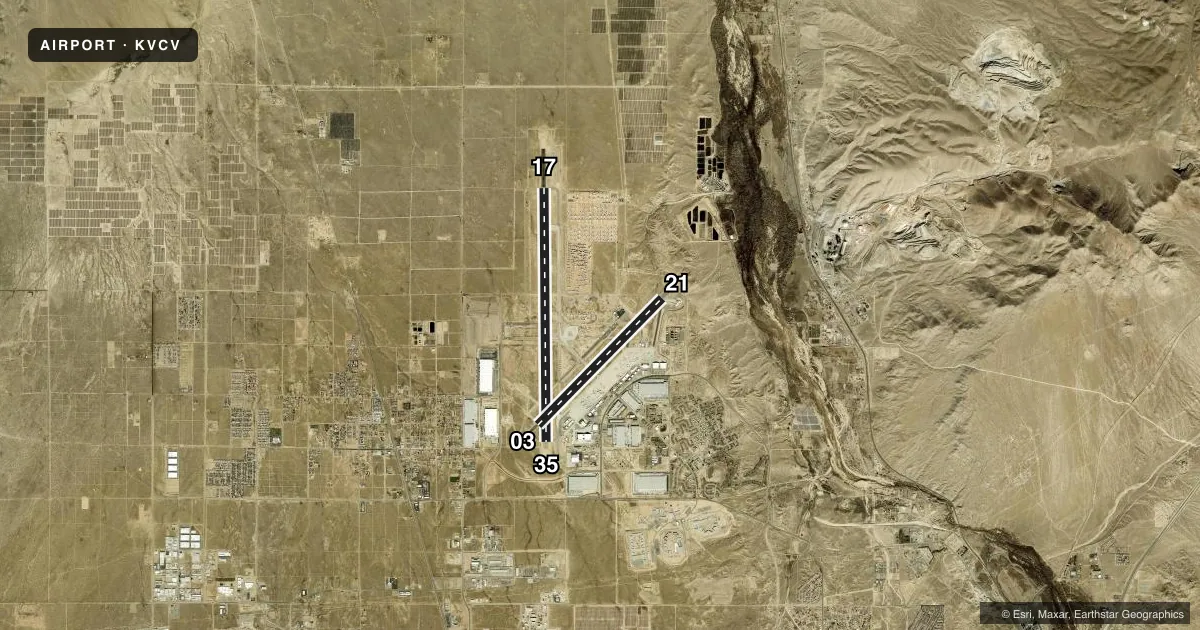
Airport sketch
Runways drawn to scale from FAA survey coordinates, rendered over satellite imagery. Not for navigation.
Approaches & charts
ILS · 1
Services on the field
Fuel grades, oxygen, maintenance, ramp storage and lighting — as declared to the FAA by the airport operator.
Fuel & services
- Fuel
- 100LLA
- Airframe repair
- Major
- Power plant repair
- Major
- Other services
- AFRT,AMB,CARGO
Ramp & ground
- Transient storage
- Tie-down
- Landing fee
- No fee published
- Customs
- Not available
- Lighting schedule
- SEE RMK
- Beacon schedule
- SS-SR
- Beacon
- White / Green (civil land)(WG)
- Wind indicator
- Lighted
- Segmented circle
- Yes
Fuel & FBOs
Cheapest 100LL and Jet A on the field and nearby. Always confirm with the FBO before taxi.
Airport notes
Surface conditions, obstructions, local procedures, lighting outages and other notes published with each FAA cycle.
General notes
- FOR ACFT FUEL OR MAINT CALL (760) 246-7794 OR USE FREQ 131.975
- AVOID OVERFLIGHT OF SILVER LAKES 10 MILES NORTH FOR NOISE ABATEMENT.
- PTN OF TWY A BTN TWY C AND RWY 21, PTN OF TWY C BTN TWY A AND TWY B, PTN OF TWY C BTN TWYS C1 AND C2, PTN OF TWY E BTN TWY E1 AND TWY D, RWY 17 THLD, AND RWY 35 THLD ARE NOT VISIBLE AREAS FROM THE ATCT. VCV ATCT UNA TO PRVD ATC SVCS TO ACFT IN THESE NON-VISIBLE AREAS.
- TWY U NOT AVBL FOR GA OR ACR USE. NOT LGTD.
- PTN OF RWY 17 NORTH 3000 FT ARE NOT VISIBLE AREAS FROM TOWER.
- WHEN ATCT CLSD, FOR CD CTC JOSHUA APCH AT 661-277-3843.
Lighting notes
- WHEN ATCT CLSD ACTVT PAPI RWY 03, 21, 17 & 35; HIRL RWYS 03/21 & 17/35 - CTAF.
Runway surface & condition
- 03/21PCR VALUE: 518/F/B/X/U
- 17/35PCR VALUE: 473/F/A/W/U
Other notes
- NO OBJECTION.
- OPR HRS 2200-0600.
- ARFF INDEX A, WITH ARFF INDEX E AVBL WITH 24 HRS PPR; CALL OPNS (760) 243-1915.
- U.S. CUSTOMS USER FEE ARPT. CUSTOMS OFFICER AVBL 1700-0100Z++ MON-FRI 760-243-1925, AFTER HRS CALL 760-490-8651.
- MANAGERAIRPORT OPERATIONS - 760 243-1915
VFR map & nearby airports
VFR sectional. Tap any ICAO chip to open that airport.
Key facts · KVCV
Answer card- ICAO
- KVCV
- Name
- SOUTHERN CALIFORNIA LOGISTICS
- Location
- VICTORVILLE, CALIFORNIA
- Elevation
- 2,885.3 ft MSL
- Traffic pattern altitude
- 3,885.3 ft MSL (1,000 AGL)
- Control tower
- Towered · 0600-2000
- Total runways
- 2
- Longest runway
- 17/35 · 13,052 ft
- Published ILS approaches
- 1
- Published frequencies
- 8
- Magnetic variation
- 14°
- Current flight rules
- VFR
- Current wind
- 200° at 6 kt
- Favored runway now
- RWY 17
Southern California Logistics is in Victorville, California. The field elevation is 2,885.3 ft MSL. It has two runways. The longest is 17/35 at 13,052 ft. The other runway is 03/21 at 9,138 ft. The airport has a control tower. Tower hours are 0600 to 2000.
There is one ILS approach. It serves runway 17. Pattern altitude is not published in the facts. Use the current Chart Supplement before you go. Million Air Victorville is on the field. It carries 100LL, Jet A and Jet A Prist. For fuel or maintenance, call the FBO directly at (760) 246-7794 or use 131.975.
This is a U.S. Customs user fee airport. Customs is available 1700 to 0100 Zulu Monday through Friday. The airport also has published lighting notes for when the tower is closed. Victorville is a high-elevation desert airport. Expect density altitude to matter, especially on warm days. Taxiway and runway visibility limits are published for tower operations, so read the current Chart Supplement before arrival. Runway 17/35 has a published pavement rating of 473/F/A/W/U. Airport operations can be reached at 760 243-1915.