METAR & TAF KUNV
Current METAR
Observed 15:53Z
KUNV 271553Z VRB03KT 10SM SCT024 SCT041 SCT048 26/20 A2990
- Wind
- VAR @ 3 kt
- Visibility
- 10 SM
- Temp / Dew
- 26°C / 20°C
- Altimeter
- 29.90 inHg
- Clouds
- SCT
- Density alt
- 2,872 ft
- Ceiling
- Unlimited
- Rules
- VFR
Airport info & contacts
Manager on record, flight service, ARTCC, attendance schedule and pattern altitude — published by the FAA and refreshed every 28 days.
Location
- From city
- 3 NM N
- VFR sectional
- DETROIT
- ARTCC
- ZNY · NEW YORK
- NOTAM facility
- UNV (NOTAM-D)
Airport manager
- Name
- BRYAN RODGERS
- Phone
- 814-865-4042
- Address
- 2535 FOX HILL RD, STATE COLLEGE PA 16803
Flight service · Hours
- FSS AOO
- ALTOONA1-800-WX-BRIEF
- Attendance
- ALL
Frequencies
Tap any row to copy the frequency to your clipboard.
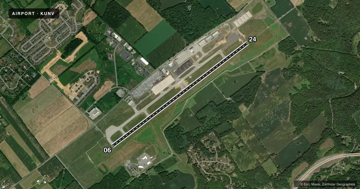
Runways & pattern
Full pagePattern entry · RWY 06
RIGHT TRAFFICRunway end performance
| End | TORA | TODA | ASDA | LDA | VGSI | Approach lights | Obstruction |
|---|---|---|---|---|---|---|---|
| 06 | 6,701' | 6,701' | 6,701' | 6,701' | PAPI 4-box left(3°) | — | — |
| 24 | 6,701' | 6,701' | 6,701' | 6,701' | PAPI 4-box right(3°) | MALSR | 86', trees, 2745' from thr, 106' R of cntrln, slope 29 |
Declared distances in feet. TORA = takeoff run available, TODA = takeoff distance, ASDA = accelerate-stop, LDA = landing distance.
Airport sketch
Runways drawn to scale from FAA survey coordinates, rendered over satellite imagery. Not for navigation.
Approaches & charts
ILS · 1
Services on the field
Fuel grades, oxygen, maintenance, ramp storage and lighting — as declared to the FAA by the airport operator.
Fuel & services
- Fuel
- 100LLA
- Oxygen (bottled)
- Low pressure
- Oxygen (bulk)
- Not available
- Airframe repair
- Major
- Power plant repair
- Minor
- Other services
- AMB,CARGO,CHTR,INSTR,RNTL
Ramp & ground
- Transient storage
- Tie-down
- Hangar
- Landing fee
- Yes
- Customs
- Not available
- Lighting schedule
- SEE RMK
- Beacon schedule
- SS-SR
- Beacon
- White / Green (civil land)(WG)
- Wind indicator
- Lighted
- Segmented circle
- Yes
Fuel & FBOs
Cheapest 100LL and Jet A on the field and nearby. Always confirm with the FBO before taxi.
Airport notes
Surface conditions, obstructions, local procedures, lighting outages and other notes published with each FAA cycle.
General notes
- ACFT ON EITHER END RWY 06/24 CANNOT BE SEEN ON OTHER END DUE TO RWY GRADE.
- STUDENT TRAINING 2.5 NM NE AT BELLEFONTE ARPT.
- DEICING EQUIP AVBL ON APN ADJ TO TWY B BTN TWYS D & B3.
- (A76) SAWRS.
- 35 FT AGL LGT POLES ON THE N EDGE OF DEICE APN.
- AIR CGO APRN RSTD TO ACFT LESS THAN 12500 LBS.
Lighting notes
- WHEN ATCT CLSD ACTVT MALSR RWY 24; REIL RWY 06; HIRL RWY 06/24 & TWY LGTS - CTAF.
Runway surface & condition
- 06/24PCR VALUE: 600/F/C/X/T
Other notes
- PPR 24 HRS FOR UNSKED ACR OPS WITH MORE THAN 9 PAX SEATS AND FOR ARFF COVERAGE BTN 0400-0900Z CALL AMGR.
- LNDG FEE FOR SNGL ENG, MULTI ENG ACFT & HELICOPTERS. SPL EVENT FEE FOR SNGL ENG, MULTI ENG ACFT & HELICOPTERS ON UNIVERSITY HOME FOOTBALL GAME WKENDS.
- TRAFFIC PATTERN ALTITUDE FOR SINGLE ENGINE ACRFT 961 FT; MULTI ENGINE ACRFT 1461 FT.
- 06/24GRVD PORTION OF RY CTR 80 FT.
VFR map & nearby airports
VFR sectional. Tap any ICAO chip to open that airport.
Key facts · KUNV
Answer card- ICAO
- KUNV
- Name
- STATE COLLEGE RGNL
- Location
- STATE COLLEGE, PENNSYLVANIA
- Elevation
- 1,231.3 ft MSL
- Traffic pattern altitude
- 2,231.3 ft MSL (1,000 AGL)
- Control tower
- Towered · 0600-2200
- Total runways
- 1
- Longest runway
- 06/24 · 6,701 ft
- Published ILS approaches
- 1
- Published frequencies
- 6
- Magnetic variation
- 11°
- Current flight rules
- VFR
- Current wind
- 000° at 3 kt
- Favored runway now
- RWY 06
State College Rgnl is in State College, Pennsylvania. The field elevation is 1,231.3 ft MSL. It has one runway, 06/24, which is 6,701 ft long. The airport is towered. The tower is open 0600-2200. Runway 24 has an ILS approach. The published traffic pattern altitude is 961 ft MSL for single-engine aircraft. It is 1,461 ft MSL for multi-engine aircraft.
Penn State Aviation Center is on the field. It carries 100LL, Jet A and Jet A Prist. If you need fuel or ramp details, call them at (814) 865-5511 x3 before you go. The Chart Supplement remarks also note deicing equipment on the apron near taxiway B. There are 35 ft light poles on the north edge of the deice apron.
This is a field where runway grade matters. Aircraft on either end of 06/24 cannot be seen from the other end. That is worth keeping in mind for taxi and runway checks. The airport also publishes a special note for larger unscheduled aircraft. Prior permission is required 24 hours in advance for operations with more than nine passenger seats between 0400 and 0900 Zulu. There is also a landing fee for fixed-wing aircraft and helicopters. Check the current FAA Chart Supplement for the latest details before you fly in.