METAR & TAF KTZR
Current METAR
Observed 16:50Z
KTZR 271650Z 22004KT 10SM CLR 27/21 A2991
- Wind
- 220° @ 4 kt
- Visibility
- 10 SM
- Temp / Dew
- 27°C / 21°C
- Altimeter
- 29.91 inHg
- Clouds
- CLR
- Density alt
- 2,574 ft
- Ceiling
- Unlimited
- Rules
- VFR
Airport info & contacts
Manager on record, flight service, ARTCC, attendance schedule and pattern altitude — published by the FAA and refreshed every 28 days.
Location
- From city
- 7 NM WSW
- VFR sectional
- CINCINNATI
- Pattern altitude
- 800 ft AGL · 1,704 ft MSL
- ARTCC
- ZID · INDIANAPOLIS
- NOTAM facility
- TZR (NOTAM-D)
Airport manager
- Name
- CHARLIE GOODWIN
- Phone
- 614-851-9900
- Address
- 2000 NORTON RD, COLUMBUS OH 43228-3667
Flight service · Hours
- FSS DAY
- DAYTON1-800-WX-BRIEF
- Attendance
- 0730-1930
Frequencies
Tap any row to copy the frequency to your clipboard.
Runways & pattern
Full pagePattern entry · RWY 22
LEFT TRAFFICRunway end performance
| End | TORA | TODA | ASDA | LDA | VGSI | Approach lights | Obstruction |
|---|---|---|---|---|---|---|---|
| 04 | — | — | — | — | PAPI 4-box left(3°) | MALSR | — |
| 22 | — | — | — | — | PAPI 4-box left(3°) | — | — |
Declared distances in feet. TORA = takeoff run available, TODA = takeoff distance, ASDA = accelerate-stop, LDA = landing distance.
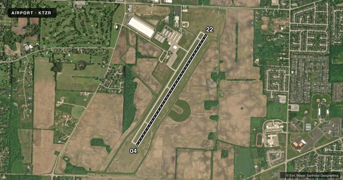
Airport sketch
Runways drawn to scale from FAA survey coordinates, rendered over satellite imagery. Not for navigation.
Approaches & charts
ILS · 1
Services on the field
Fuel grades, oxygen, maintenance, ramp storage and lighting — as declared to the FAA by the airport operator.
Fuel & services
- Fuel
- 100LLA1+
- Oxygen (bottled)
- High pressure
- Oxygen (bulk)
- Not available
- Airframe repair
- Major
- Power plant repair
- Major
- Other services
- CHTR,INSTR,RNTL,SURV
Ramp & ground
- Transient storage
- Tie-down
- Hangar
- Landing fee
- No fee published
- Customs
- Not available
- Lighting schedule
- SEE RMK
- Beacon schedule
- SS-SR
- Beacon
- White / Green (civil land)(WG)
- Wind indicator
- Lighted
- Segmented circle
- No
Fuel & FBOs
Cheapest 100LL and Jet A on the field and nearby. Always confirm with the FBO before taxi.
Airport notes
Surface conditions, obstructions, local procedures, lighting outages and other notes published with each FAA cycle.
General notes
- HIGH TENSION PLINES/TOWERS NE-SE.
- BLN & BANNER ACT ON & INVOF ARPT.
- BIRDS & OTR WILDLIFE ON & INVOF ARPT.
- FOR FUEL & ACFT SVCS CTC FBO ON 123.3.
- FOR CD WHEN ATCT IS CLSD CTC COLUMBUS APCH AT 614-338-8537.
Lighting notes
- WHEN ATCT CLSD ACTVT MALSR RWY 04; REIL RWY 22; MIRL RWY 04/22 - CTAF.
Fuel notes
- 100LL100LL AVBL H24 SELF SVC VIA CREDIT CARD.
Runway surface & condition
- 04/22PCR VALUE: 364/F/B/X/T
Approach & departure obstructions
- 04CALM WIND RWY.
Other notes
- PPR CTC AMGR FOR INFO.
- MANAGERH24 EMERG OPS 614-239-4029.
VFR map & nearby airports
VFR sectional. Tap any ICAO chip to open that airport.
Key facts · KTZR
Answer card- ICAO
- KTZR
- Name
- BOLTON FLD
- Location
- COLUMBUS, OHIO
- Elevation
- 904.2 ft MSL
- Traffic pattern altitude
- 1,704.2 ft MSL (800 AGL)
- Control tower
- Towered · 0730-1930
- Total runways
- 1
- Longest runway
- 04/22 · 5,500 ft
- Published ILS approaches
- 1
- Published frequencies
- 6
- Magnetic variation
- 5°
- Current flight rules
- VFR
- Current wind
- 220° at 4 kt
- Favored runway now
- RWY 22
Bolton Fld is in Columbus, Ohio. Field elevation is 904.2 ft MSL. The airport has one runway, 04/22, which is 5,500 ft of asphalt. Runway 04 is the calm wind runway. The field is towered from 0730 to 1930. When the tower is closed, use CTAF 128.1 for lighting activation and airport traffic calls.
An ILS is available to runway 04. Pattern altitude is 800 ft AGL. That is 1,704.2 ft MSL. Bolton Aviation is on the field. It carries 100LL, Jet A and Jet A Prist. 100LL is available 24 hours a day by self-serve credit card. For fuel and aircraft services, the FBO uses 123.3. The airport also requires prior permission. Contact the airport manager before arrival if you need access or operational details.
For a first-time arrival, watch the published notes closely. Birds and other wildlife are reported on and near the airport. Banner towing activity is also in the area. High tension power lines and towers lie northeast to southeast of the field. If you are arriving after tower hours, get clearance delivery through Columbus Approach at 614-338-8537. Check the current FAA Chart Supplement for any updated operating notes before you go.