METAR & TAF KTYR
Current METAR
Observed 14:53Z
KTYR 271453Z 23009KT 10SM CLR 30/21 A3000 RMK AO2 SLP152 T03000211 50006
- Wind
- 230° @ 9 kt
- Visibility
- 10 SM
- Temp / Dew
- 30°C / 21°C
- Altimeter
- 30.00 inHg
- Clouds
- CLR
- Density alt
- 2,375 ft
- Ceiling
- Unlimited
- Rules
- VFR
Airport info & contacts
Manager on record, flight service, ARTCC, attendance schedule and pattern altitude — published by the FAA and refreshed every 28 days.
Location
- From city
- 3 NM W
- VFR sectional
- DALLAS-FT WORTH
- ARTCC
- ZFW · FORT WORTH
- NOTAM facility
- TYR (NOTAM-D)
Airport manager
- Name
- STEVE M. THOMPSON
- Phone
- 903-531-2343
- Address
- 700 SKYWAY BLVD, SUITE 201, TYLER TX 75704
Flight service · Hours
- FSS FTW
- FORT WORTH1-800-WX-BRIEF
- Attendance
- 0500-2200
Frequencies
Tap any row to copy the frequency to your clipboard.
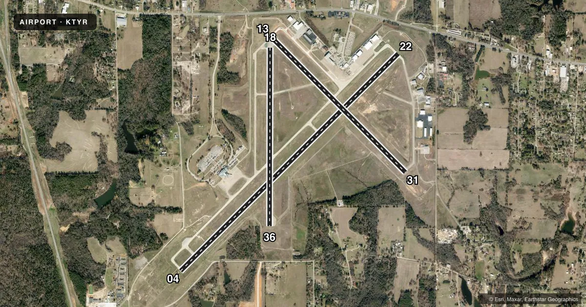
Runways & pattern
Full pagePattern entry · RWY 22
LEFT TRAFFIC| Runway | Heading (°M) | Length | Surface | Traffic |
|---|---|---|---|---|
| 04/22Favored | 42° / 222° | 8,334 ft | CONC | Standard L |
| 13/31 | 132° / 312° | 5,198 ft | ASPH | Standard L |
| 18/36 | 177° / 357° | 4,832 ft | ASPH | Standard L |
Runway end performance
| End | TORA | TODA | ASDA | LDA | VGSI | Approach lights | Obstruction |
|---|---|---|---|---|---|---|---|
| 04 | 8,334' | 8,334' | 7,734' | 7,734' | PAPI 4-box left(3°) | MALSR | — |
| 22 | 8,334' | 8,334' | 8,334' | 7,734' | PAPI 4-box left(3°) | — | 28', tree, 1146' from thr, 80' R of cntrln, slope 33 |
| 13 | 5,198' | 5,198' | 5,198' | 5,198' | — | — | 28', pole, 1550' from thr, 550' R of cntrln, slope 49 |
| 31 | 5,198' | 5,198' | 5,198' | 5,198' | VASI 4-box left(3°) | — | 14', road, 600' from thr, 520' R of cntrln, slope 28 |
| 18 | 4,832' | 4,832' | 4,832' | 4,832' | — | — | 38', tree, 1100' from thr, 13' R of cntrln, slope 23 |
| 36 | 4,832' | 4,832' | 4,832' | 4,832' | — | — | 43', tree, 1158' from thr, 239' R of cntrln, slope 30 |
Declared distances in feet. TORA = takeoff run available, TODA = takeoff distance, ASDA = accelerate-stop, LDA = landing distance.
Airport sketch
Runways drawn to scale from FAA survey coordinates, rendered over satellite imagery. Not for navigation.
Approaches & charts
ILS · 1
Services on the field
Fuel grades, oxygen, maintenance, ramp storage and lighting — as declared to the FAA by the airport operator.
Fuel & services
- Fuel
- 100LLA
- Oxygen (bottled)
- High pressure
- Oxygen (bulk)
- High pressure
- Airframe repair
- Major
- Power plant repair
- Major
- Other services
- AFRT,CARGO,CHTR,INSTR,RNTL,SALES,SURV
Ramp & ground
- Transient storage
- Tie-down
- Hangar
- Landing fee
- No fee published
- Customs
- Not available
- Lighting schedule
- SEE RMK
- Beacon schedule
- SS-SR
- Beacon
- White / Green (civil land)(WG)
- Wind indicator
- Lighted
- Segmented circle
- Yes
Fuel & FBOs
Cheapest 100LL and Jet A on the field and nearby. Always confirm with the FBO before taxi.
Airport notes
Surface conditions, obstructions, local procedures, lighting outages and other notes published with each FAA cycle.
General notes
- HELICOPTERS OPERATING INBOUND OR OUTBOUND TO/FROM THE DOWNTOWN HOSPITALS STATE INTENTION ON 123.075.
- WEST SIDE PSGR TERMINAL RAMP ACCESS RSTD TO ACR.
- NOISE ABATEMENT PROCEDURES IN EFFECT CALL 903-590-3048.
- CONDS NOT MNTD BTN THE HRS OF 9:30 PM AND 6:30 AM LOCAL.
- FOR CD IF UNA TO CTC ON FSS FREQ, CTC FORT WORTH ARTCC AT 817-858-7584.
Lighting notes
- WHEN ATCT CLSD ACTVT MALSR RWY 04; REIL RWY 22; HIRL RWY 04/22; MIRL RWY 18/36; TWY LGTS - CTAF. HIRL RWY 13/31 PRESET MED INTST, TO INCR INTST ACTVT - CTAF. PAPI RWYS 04 & 22, VASI RWY 31 OPR CONSLY.
Runway surface & condition
- 04/22PCR VALUE: 640/R/B/W/T
- 13/31PCR VALUE: 150/F/D/X/T
- 18/36PCR VALUE: 670/F/C/X/T
Approach & departure obstructions
- 22UNUSBL BYD 9 DEG LEFT AND RIGHT OF RWY CNTRLN.
VFR map & nearby airports
VFR sectional. Tap any ICAO chip to open that airport.
Key facts · KTYR
Answer card- ICAO
- KTYR
- Name
- TYLER POUNDS RGNL
- Location
- TYLER, TEXAS
- Elevation
- 543.9 ft MSL
- Traffic pattern altitude
- 1,543.9 ft MSL (1,000 AGL)
- Control tower
- Towered · 0630-2130
- Total runways
- 3
- Longest runway
- 04/22 · 8,334 ft
- Published ILS approaches
- 1
- Published frequencies
- 10
- Magnetic variation
- 3°
- Current flight rules
- VFR
- Current wind
- 230° at 9 kt
- Favored runway now
- RWY 22
Tyler Pounds Rgnl is in Tyler, Texas. The field elevation is 543.9 ft MSL. It has 3 runways. The longest is runway 04/22 at 8,334 ft. The airport has a control tower. Tower hours are 0630-2130 local. One ILS is published for runway 04.
Pattern altitude is not published in the facts. Use the standard 1,000 ft AGL for light piston traffic unless the current Chart Supplement says otherwise. That puts the pattern near 1,544 ft MSL based on the field elevation. Verify before flight if you need an exact number for your operation.
Johnson Aviation is on the field. It carries 100LL, Jet A and Jet A Prist. Jet Center of Tyler is also on the field. It carries 100LL and Jet A Prist. Published remarks say noise abatement procedures are in effect. Call the airport for the current procedure before arrival. The field also has lighting notes that matter after tower hours. When the tower is closed, pilots should use CTAF for lighting activation. Runway 04 has approach lighting and runway alignment lights. Runway 13/31 lights are preset to medium intensity. The airport is in a busy towered environment. Watch your radio work. Expect standard controlled-field sequencing.