METAR & TAF KTYQ
Current METAR
Observed 14:55Z
KTYQ 271455Z AUTO 06005KT 5SM BR BKN007 BKN032 26/24 A2992 RMK AO2 T02560242
- Wind
- 060° @ 5 kt
- Visibility
- 5 SM
- Temp / Dew
- 26°C / 24°C
- Altimeter
- 29.92 inHg
- Clouds
- BKN
- Density alt
- 2,464 ft
- Ceiling
- 700 ft AGL
- Rules
- IFR
Airport info & contacts
Manager on record, flight service, ARTCC, attendance schedule and pattern altitude — published by the FAA and refreshed every 28 days.
Location
- From city
- 14 NM NW
- VFR sectional
- CHICAGO
- ARTCC
- ZID · INDIANAPOLIS
- NOTAM facility
- HUF (NOTAM-D)
Airport manager
- Name
- SAM SACHS
- Phone
- 317-385-3015
- Address
- 11329 E. STATE RD 32, ZIONSVILLE IN 46077
Flight service · Hours
- FSS HUF
- TERRE HAUTE1-800-WX-BRIEF
- Attendance
- 0600-2000
Frequencies
Tap any row to copy the frequency to your clipboard.
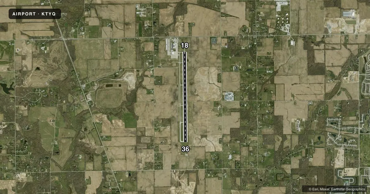
Runways & pattern
Full pagePattern entry · RWY 36
LEFT TRAFFICRunway end performance
| End | TORA | TODA | ASDA | LDA | VGSI | Approach lights | Obstruction |
|---|---|---|---|---|---|---|---|
| 18 | — | — | — | — | PAPI 4-box left(3°) | — | 24', hangar, 670' from thr, 540' R of cntrln, slope 19 |
| 36 | — | — | — | — | PAPI 4-box left(3°) | — | 35', tree, 1175' from thr, 200' R of cntrln, slope 27 |
Declared distances in feet. TORA = takeoff run available, TODA = takeoff distance, ASDA = accelerate-stop, LDA = landing distance.
Airport sketch
Runways drawn to scale from FAA survey coordinates, rendered over satellite imagery. Not for navigation.
Approaches & charts
ILS · 1
Services on the field
Fuel grades, oxygen, maintenance, ramp storage and lighting — as declared to the FAA by the airport operator.
Fuel & services
- Fuel
- 100LLAA+
- Oxygen (bottled)
- High pressure
- Oxygen (bulk)
- HIGH/LOW
- Airframe repair
- Major
- Power plant repair
- Major
- Other services
- AFRT,AMB,AVNCS,CARGO,CHTR,INSTR,RNTL,SALES
Ramp & ground
- Transient storage
- Tie-down
- Hangar
- Landing fee
- No fee published
- Lighting schedule
- SEE RMK
- Beacon schedule
- SS-SR
- Beacon
- White / Green (civil land)(WG)
- Wind indicator
- Lighted
- Segmented circle
- No
Fuel & FBOs
Cheapest 100LL and Jet A on the field and nearby. Always confirm with the FBO before taxi.
Airport notes
Surface conditions, obstructions, local procedures, lighting outages and other notes published with each FAA cycle.
General notes
- FOR CD CTC INDIANAPOLIS APCH AT 317-227-5743.
- COND NOT MNT 2000-0600.
- REMOTE CTL ACFT ACT 0.1 NM W OF RWY 18/36 SFC-400 FT.
- FUEL & SVC - 130.4
- BIRDS ON & INVOF ARPT
Lighting notes
- ACTVT REIL RWY 18 & 36; HIRL RWY 18/36 - CTAF. HIRL RWY 18/36 PRESET MED INTST DUSK - DAWN; INCR INTST- CTAF. PAPI RWY 18 & 36 OPR CONSLY.
Fuel notes
- 100LL100LL SELF SVC H24 WITH CREDIT CARD.
Runway surface & condition
- 18/36RWY 36 CALM/XWIND RWY.
Approach & departure obstructions
- 1810 FT CROPS 230 FT E OF RWY CNTRLN.
Other notes
- 1SVC AFT HR - 317-769-4487.
VFR map & nearby airports
VFR sectional. Tap any ICAO chip to open that airport.
Key facts · KTYQ
Answer card- ICAO
- KTYQ
- Name
- INDIANAPOLIS EXEC
- Location
- INDIANAPOLIS, INDIANA
- Elevation
- 922.2 ft MSL
- Traffic pattern altitude
- 1,922.2 ft MSL (1,000 AGL)
- Control tower
- Non-towered (use CTAF)
- Total runways
- 1
- Longest runway
- 18/36 · 7,001 ft
- Published ILS approaches
- 1
- Published frequencies
- 6
- Magnetic variation
- 3°
- Current flight rules
- IFR
- Current wind
- 060° at 5 kt
- Favored runway now
- RWY 36
Indianapolis Exec is in Indianapolis, Indiana. The field elevation is 922.2 ft MSL. It has one runway. The longest runway is 7,001 ft of concrete. There is no control tower. Clearance delivery is handled through Indianapolis Approach. The airport has one ILS approach to runway 36.
Pattern altitude is not published. Use the standard 1,000 ft AGL pattern for light piston aircraft unless the current Chart Supplement says otherwise. Runway 36 is listed as the calm and crosswind runway. That is useful when the wind is light or variable. Runway end identifier lights are active on 18 and 36. The high intensity runway lights are controlled on CTAF. The PAPI on both ends operates continuously.
Jet Access is on the field. It carries AVGAS 100LL. It also carries Jet A and Jet A Prist. 100LL self-service is available 24 hours with credit card. Birds are reported on and near the airport. There are also 10 ft crops 230 ft east of the runway centerline near the runway 18 end. Conditions are not maintained from 2000 to 0600. Remote controlled aircraft activity occurs 0.1 NM west of runway 18/36 surface up to 400 ft. For a first trip, plan for a busy metro airport. Verify current airspace and approach details. Be ready to work with Indianapolis Approach.