METAR & TAF KTTN
Current METAR
Observed 12:53Z
KTTN 271253Z 25004KT 10SM CLR 23/19 A2984 RMK AO2 SLP096 T02330189 $
- Wind
- 250° @ 4 kt
- Visibility
- 10 SM
- Temp / Dew
- 23°C / 19°C
- Altimeter
- 29.84 inHg
- Clouds
- CLR
- Density alt
- 1,323 ft
- Ceiling
- Unlimited
- Rules
- VFR
Airport info & contacts
Manager on record, flight service, ARTCC, attendance schedule and pattern altitude — published by the FAA and refreshed every 28 days.
Location
- From city
- 4 NM NW
- VFR sectional
- NEW YORK
- ARTCC
- ZNY · NEW YORK
- NOTAM facility
- TTN (NOTAM-D)
Airport manager
- Name
- KURT NEINSTEDT
- Phone
- 609-882-1601
- Address
- 340 SCOTCH ROAD, SUITE 200, EWING NJ 08628
Flight service · Hours
- FSS MIV
- MILLVILLE1-800-WX-BRIEF
- Attendance
- ALL
Frequencies
Tap any row to copy the frequency to your clipboard.
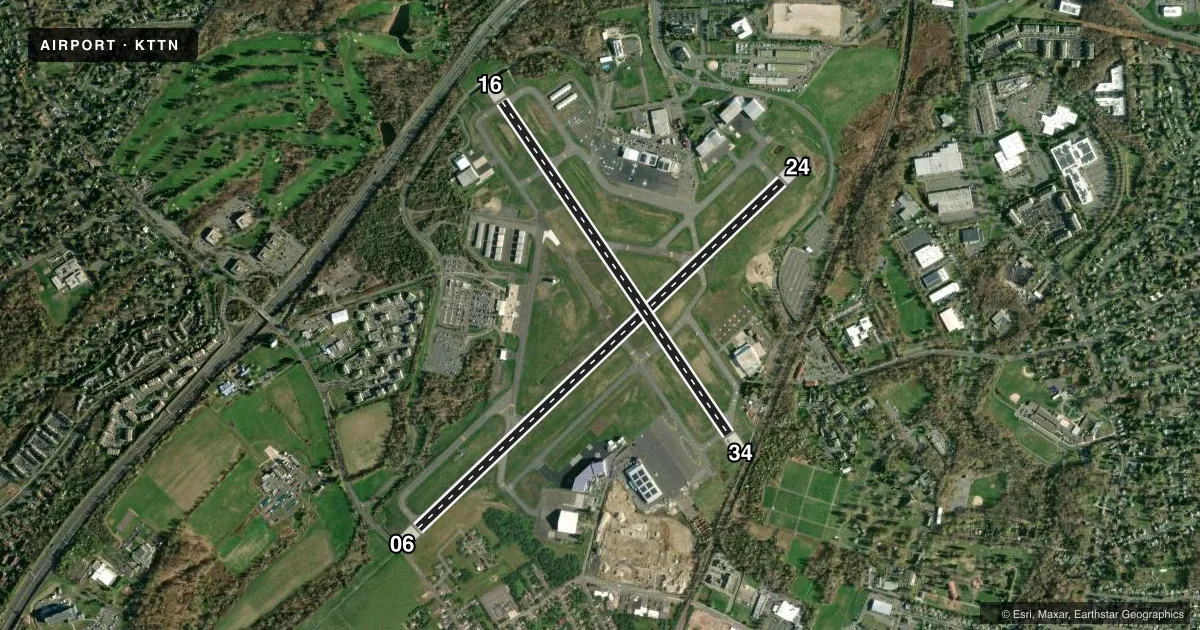
Runways & pattern
Full pagePattern entry · RWY 24
LEFT TRAFFIC| Runway | Heading (°M) | Length | Surface | Traffic |
|---|---|---|---|---|
| 06/24Favored | 34° / 214° | 6,006 ft | ASPH | Standard L |
| 16/34 | 134° / 314° | 4,800 ft | ASPH | Standard L |
Runway end performance
| End | TORA | TODA | ASDA | LDA | VGSI | Approach lights | Obstruction |
|---|---|---|---|---|---|---|---|
| 06 | 6,006' | 6,006' | 6,006' | 6,006' | — | MALSR | 87', tree, 2120' from thr, 790' R of cntrln, slope 22 |
| 24 | 6,006' | 6,006' | 6,006' | 6,006' | PAPI 4-box left(3°) | — | — |
| 16 | 4,800' | 4,800' | 4,800' | 4,800' | PAPI 4-box left(3°) | — | — |
| 34 | 4,800' | 4,800' | 4,800' | 4,800' | PAPI 4-box left(3°) | — | — |
Declared distances in feet. TORA = takeoff run available, TODA = takeoff distance, ASDA = accelerate-stop, LDA = landing distance.
Airport sketch
Runways drawn to scale from FAA survey coordinates, rendered over satellite imagery. Not for navigation.
Approaches & charts
ILS · 1
Services on the field
Fuel grades, oxygen, maintenance, ramp storage and lighting — as declared to the FAA by the airport operator.
Fuel & services
- Fuel
- 100LLAA+
- Oxygen (bottled)
- Low pressure
- Oxygen (bulk)
- Low pressure
- Airframe repair
- Major
- Power plant repair
- Major
- Other services
- CHTR,INSTR,RNTL,SALES
Ramp & ground
- Transient storage
- Tie-down
- Hangar
- Landing fee
- Yes
- Customs
- Not available
- Lighting schedule
- SEE RMK
- Beacon schedule
- SS-SR
- Beacon
- White / Green (civil land)(WG)
- Wind indicator
- Lighted
- Segmented circle
- No
Fuel & FBOs
Cheapest 100LL and Jet A on the field and nearby. Always confirm with the FBO before taxi.
Airport notes
Surface conditions, obstructions, local procedures, lighting outages and other notes published with each FAA cycle.
General notes
- GEESE & FLOCKS OF SEA GULLS & DEER ON & INVOF ARPT.
- NOISE ABATEMENT PROCS IN EFCT; DEPS OVER 12500 LBS FLY RY HEADING UNTIL 1700 FT MSL; DEPS UNDER 12500 LBS FLY RY HEADING UNTIL 1200 FT MSL.
- NO TGL OR TRAINING OPNS 2200-0700.
- FOR CD WHEN ATCT IS CLSD CTC PHL APCH AT (800) 354-9884.
- VOLUNTARY CURFEW 0000-0600 LCL.
- TWR VIEW OF TWY J OBSC CTN ADZ.
- ARFF MNTS GND AND ATCT FREQS DURG ATC ZERO EVENTS.
- TWY E CLSD TO ACFT WINGSPAN MORE THAN 110FT EXC 24HR PPR 609-883-0994.
- TWY C CLSD TO ACFT MORE THAN 40000 LB.
Lighting notes
- WHEN ATCT CLSD ACTVT HIRL RY 06/24; HIRL RY 16/34; MALSR RY 06; PAPI RYS 24; 16; 34; REIL RYS 24; 16; 34 & TWY LGTS - CTAF.
Fuel notes
- 100LLFUEL AVBL ON 24/7.
Runway surface & condition
- 06/24PCR VALUE: 590/F/B/X/T
- 16/34PCR VALUE: 700/F/B/X/T
- H1LOCATED AT INTXN OF TWYS 'H' & 'H1'.
- H2LCTD AT NORTHEAST END OF TWY 'B'.
Approach & departure obstructions
- 06RWY 06, 185 FT LGTD POLE; 100 FT FROM THRESHOLD, 500 FT R.
Arresting gear
- 06_EMASRY 6 ENGINEERED MATERIAL ARRESTING SYSTEM 308X162 DEP END.
- 16_EMASRY 16, ENGINEERED MATERIALS ARRESTING SYSTEM (EMAS), 247 FT LONG BY 162 FT WIDE, LCTD DER 16.
- 24_EMASRY 24 ENGINEERED MATERIAL ARRESTING SYSTEM 251X162 DEP END.
- 34_EMASRY 34 ENGINEERED MATERIALS ARRESTING SYSTEM (EMAS), 226 FT LONG BY 162 FT WIDE, LCTD DER 34.
Other notes
- LDG FEE FOR ALL TRANSIENT ACFT.
- TPA FOR ACFT UNDER 12500 LBS 1200 FT MSL; ACFT 12500 LBS & OVER 1700 FT MSL.
VFR map & nearby airports
VFR sectional. Tap any ICAO chip to open that airport.
Key facts · KTTN
Answer card- ICAO
- KTTN
- Name
- TRENTON MERCER
- Location
- TRENTON, NEW JERSEY
- Elevation
- 212.6 ft MSL
- Traffic pattern altitude
- 1,212.6 ft MSL (1,000 AGL)
- Control tower
- Towered · 0600-2200
- Total runways
- 2
- Longest runway
- 06/24 · 6,006 ft
- Published ILS approaches
- 1
- Published frequencies
- 13
- Magnetic variation
- 12°
- Current flight rules
- VFR
- Current wind
- 250° at 4 kt
- Favored runway now
- RWY 24
Trenton Mercer Airport sits in Trenton, New Jersey. Field elevation is 212.6 ft MSL. The airport has two asphalt runways. The longest is 6,006 ft. The tower is open 0600-2200 local. One ILS is published for runway 06. Pattern altitude is 1,200 ft MSL for aircraft under 12,500 pounds. Pattern altitude is 1,700 ft MSL for aircraft 12,500 pounds and over.
FlightServ is on the field. Signature Aviation is on the field. Both carry AVGAS 100LL and Jet A. 100LL is available 24 hours a day, 7 days a week. There is a voluntary curfew from 0000 to 0600 local. Noise abatement procedures are in effect. Departures under 12,500 pounds fly runway heading until 1,200 ft MSL. Departures 12,500 pounds and over fly runway heading until 1,700 ft MSL.
A first-time pilot should plan for a busy controlled field with published procedures. Runway 06 has a lighted pole near the threshold on the right side. Taxiway C is closed to aircraft more than 40,000 pounds. Taxiway E needs prior permission for wingspans over 110 feet. Geese, gulls and deer are reported in the area. Landing fees apply to all transient aircraft. Check the current FAA Chart Supplement before departure for the latest operational details.