METAR & TAF KTIX
Current METAR
Observed 12:47Z
KTIX 271247Z 25005KT 7SM SCT050 A2994
- Wind
- 250° @ 5 kt
- Visibility
- 7 SM
- Temp / Dew
- —
- Altimeter
- 29.94 inHg
- Clouds
- SCT
- Density alt
- —
- Ceiling
- Unlimited
- Rules
- VFR
Airport info & contacts
Manager on record, flight service, ARTCC, attendance schedule and pattern altitude — published by the FAA and refreshed every 28 days.
Location
- From city
- 5 NM S
- VFR sectional
- JACKSONVILLE
- ARTCC
- ZJX · JACKSONVILLE
- NOTAM facility
- TIX (NOTAM-D)
Airport manager
- Name
- KEVIN DAUGHERTY, AAE
- Phone
- 321-267-8780
- Address
- 51 BRISTOW WAY, TITUSVILLE FL 32780
Flight service · Hours
- FSS PIE
- SAINT PETERSBURG1-800-WX-BRIEF
- Attendance
- 0700-2100
Frequencies
Tap any row to copy the frequency to your clipboard.
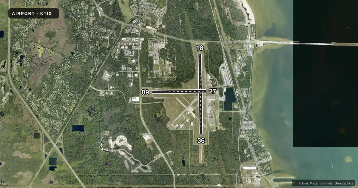
Runways & pattern
Full pagePattern entry · RWY 27
LEFT TRAFFIC| Runway | Heading (°M) | Length | Surface | Traffic |
|---|---|---|---|---|
| 18/36 | 174° / 354° | 7,319 ft | ASPH | Standard L |
| 09/27Favored | 84° / 264° | 5,000 ft | ASPH | Standard L |
Runway end performance
| End | TORA | TODA | ASDA | LDA | VGSI | Approach lights | Obstruction |
|---|---|---|---|---|---|---|---|
| 18 | 7,319' | 7,319' | 7,249' | 6,930' | PAPI 4-box left(3°) | — | 52', trees, 1465' from thr, 45' R of cntrln, slope 24 |
| 36 | 7,319' | 7,319' | 7,244' | 7,244' | PAPI 4-box left(3°) | MALSR | 24', trees, 1155' from thr, 365' R of cntrln, slope 39 |
| 09 | 5,000' | 5,000' | 5,000' | 5,000' | PAPI 4-box left(3°) | — | 29', trees, 1215' from thr, 240' R of cntrln, slope 34 |
| 27 | 5,000' | 5,000' | 5,000' | 5,000' | PAPI 4-box left(3°) | — | 53', trees, 1260' from thr, 265' R of cntrln, slope 20 |
Declared distances in feet. TORA = takeoff run available, TODA = takeoff distance, ASDA = accelerate-stop, LDA = landing distance.
Airport sketch
Runways drawn to scale from FAA survey coordinates, rendered over satellite imagery. Not for navigation.
Approaches & charts
ILS · 1
Services on the field
Fuel grades, oxygen, maintenance, ramp storage and lighting — as declared to the FAA by the airport operator.
Fuel & services
- Fuel
- 100LLA
- Oxygen (bottled)
- Not available
- Oxygen (bulk)
- Not available
- Airframe repair
- Major
- Power plant repair
- Major
- Other services
- AVNCS,CHTR,INSTR,RNTL,SALES
Ramp & ground
- Transient storage
- Tie-down
- Hangar
- Landing fee
- No fee published
- Customs
- Not available
- Lighting schedule
- SEE RMK
- Beacon schedule
- SS-SR
- Beacon
- White / Green (civil land)(WG)
- Wind indicator
- Lighted
- Segmented circle
- No
Fuel & FBOs
Cheapest 100LL and Jet A on the field and nearby. Always confirm with the FBO before taxi.
Airport notes
Surface conditions, obstructions, local procedures, lighting outages and other notes published with each FAA cycle.
General notes
- IN MINIMUM VIS CONDS BRIGHT LGTS IN PARKING LOT 1/4 MILE E OF RY 18 MAY BE MISTAKEN FOR RY LGTS.
- ATCT UNABLE AIR TRAFFIC SVCS ON THESE AREAS OF NON-VISIBILITY: SOUTHWEST PORTIONS OF TAXILANES 'D' AND 'E'.
- FOR CD OR TO CNL IFR IF UNA TO CTC ON FSS FREQ, CTC ORLANDO APCH AT 407-852-7500.
Lighting notes
- WHEN ATCT CLSD ACTVT MALSR RWY 36; REIL RWYS 9, 18, & 27; PAPI RWYS 09, 27, 18, & 36; MIRL RWY 09/27; HIRL RWY 18/36 - CTAF.
Fuel notes
- 100LLFOR FUEL AFT HRS CALL 321-267-8355
Runway surface & condition
- 09/27PCR VALUE: 350/F/A/X/T
- 18/36PCR VALUE: 580/F/B/X/T
- 18/36RWY 18/36 NOT AVBL FOR PART 121/PART 380 OPS WITH SKED PAX CARRYING OPS MORE THAN 9 PAX SEATS AND NON-SKED PAX CARRYING OPS MORE THAN 30 PAX SEATS.
Approach & departure obstructions
- 18TREES 425 FT LEFT & RIGHT OF CNTRLN FIRST 1500 FT OF RWY 18.
Other notes
- CLSD TO ACR OPNS WITH MORE THAN 30 PAX SEATS EXC PPR CALL AMGR 321-267-8780. INDEX A ARFF EQUIPMENT AVAILABLE MONDAY-FRIDAY 0700-1600 L OR UPON REQ. CONTACT ARPT FIRE CHIEF TO COORD 321-289-5393.
VFR map & nearby airports
VFR sectional. Tap any ICAO chip to open that airport.
Key facts · KTIX
Answer card- ICAO
- KTIX
- Name
- SPACE COAST RGNL
- Location
- TITUSVILLE, FLORIDA
- Elevation
- 34 ft MSL
- Traffic pattern altitude
- 1,034 ft MSL (1,000 AGL)
- Control tower
- Towered · 0700-2100
- Total runways
- 2
- Longest runway
- 18/36 · 7,319 ft
- Published ILS approaches
- 1
- Published frequencies
- 9
- Magnetic variation
- 5°
- Current flight rules
- VFR
- Current wind
- 250° at 5 kt
- Favored runway now
- RWY 27
Space Coast Rgnl is in Titusville, Florida. Field elevation is 34 ft MSL. The airport has two asphalt runways. The longest is runway 18/36 at 7,319 ft. Tower service is published from 0700 to 2100 local. One ILS is available to runway 36.
Pattern altitude is not published. Use 1,000 ft AGL for light piston traffic unless ATC or the current Chart Supplement says otherwise. The on-field FBO is Space Coast Executive Jet Center. It carries 100LL and Jet A. If you need fuel after hours, call the FBO directly.
This field has a few operational points worth planning for. Bright parking lot lights one quarter mile east of runway 18 can be mistaken for runway lights in low visibility. The tower cannot provide air traffic services in the southwest portions of taxilanes D and E when visibility is poor. Runway 18/36 has published limits for some larger passenger operations. Check the current Chart Supplement if you are planning anything outside normal general aviation use. The airport sits on the Space Coast. Expect a busy Florida environment with standard sea-level performance. Brief for winds, humidity and traffic before you go in.