METAR & TAF KTEX
Current METAR
Observed 12:15Z
KTEX 271215Z AUTO 15004KT 10SM CLR 12/08 A3050 RMK AO2
- Wind
- 150° @ 4 kt
- Visibility
- 10 SM
- Temp / Dew
- 12°C / 8°C
- Altimeter
- 30.50 inHg
- Clouds
- CLR
- Density alt
- 10,167 ft
- Ceiling
- Unlimited
- Rules
- VFR
Airport info & contacts
Manager on record, flight service, ARTCC, attendance schedule and pattern altitude — published by the FAA and refreshed every 28 days.
Location
- From city
- 5 NM W
- VFR sectional
- DENVER
- Pattern altitude
- 1,414 ft AGL · 10,484 ft MSL
- ARTCC
- ZDV · DENVER
- NOTAM facility
- TEX (NOTAM-D)
Airport manager
- Name
- KENNETH E. MAENPA
- Phone
- (970) 728-8601
- Address
- 1500 LAST DOLLAR RD. SUITE 1, TELLURIDE CO 81435
Flight service · Hours
- FSS DEN
- DENVER1-800-WX-BRIEF
- Attendance
- APR-OCT · 0700-2100
- NOV-MAR · 0700-1800
Frequencies
Tap any row to copy the frequency to your clipboard.
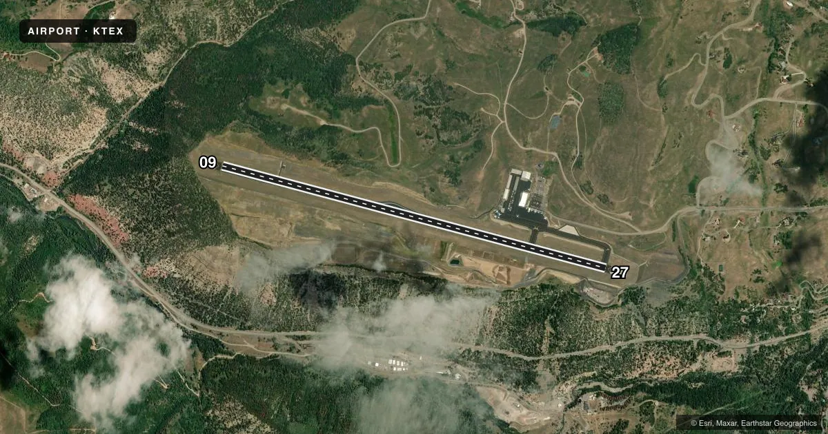
Runways & pattern
Full pagePattern entry · RWY 09
RIGHT TRAFFICRunway end performance
| End | TORA | TODA | ASDA | LDA | VGSI | Approach lights | Obstruction |
|---|---|---|---|---|---|---|---|
| 09 | 7,111' | 7,111' | 7,111' | 6,911' | PAPI 4-box left(3.55°) | — | — |
| 27 | 7,111' | 7,111' | 7,111' | 6,911' | PAPI 4-box left(4°) | — | — |
Declared distances in feet. TORA = takeoff run available, TODA = takeoff distance, ASDA = accelerate-stop, LDA = landing distance.
Airport sketch
Runways drawn to scale from FAA survey coordinates, rendered over satellite imagery. Not for navigation.
Approaches & charts
ILS · 1
Services on the field
Fuel grades, oxygen, maintenance, ramp storage and lighting — as declared to the FAA by the airport operator.
Fuel & services
- Fuel
- 100LLA
- Oxygen (bottled)
- HIGH/LOW
- Oxygen (bulk)
- HIGH/LOW
- Other services
- AFRT,CHTR,GLD
Ramp & ground
- Transient storage
- Tie-down
- Hangar
- Landing fee
- Yes
- Lighting schedule
- SEE RMK
- Beacon schedule
- SS-SR
- Beacon
- White / Green (civil land)(WG)
- Wind indicator
- Lighted
- Segmented circle
- Yes
Fuel & FBOs
Cheapest 100LL and Jet A on the field and nearby. Always confirm with the FBO before taxi.
Airport notes
Surface conditions, obstructions, local procedures, lighting outages and other notes published with each FAA cycle.
General notes
- GLIDER; HANG GLIDER & HELICOPTER OPNS ON & INVOF ARPT.
- NOISE ABATEMENT PROCEDURES IN EFFECT. FOR MORE INFO CONTACT TEX CUSTOMER SERVICE 970-728-8600.
- RISING TERRAIN ALL QUADRANTS.
- ARPT ON 1000 FT MESA; STRONG VERTICAL TURBULENCE IN AREA OF MESA EDGE.
- ACR OPNS DURG UNATNDD HRS MUST NTFY TEX CUSTOMER SVC AT 970-728-8603 24 HRS IN ADVN FOR PROVISION OF ADQT ARFF PSNL.
- TEX RWY 27 PAPI BEYOND 2.5NM UNUSBL
- FOR CD CONTACT DENVER ARTCC AT 303-651-4814. IF UNA TO CTC DENVER ARTCC, CTC DENVER RADIO.
- COLD TEMPERATURE AIRPORT. ALTITUDE CORRECTION REQUIRED AT OR BELOW -17C.
Lighting notes
- ACTVT HIRL RY 09/27; PAPI RYS 09 & 27; REIL RY 09/27 - CTAF. ALS EMERGENCY USE ONLY 2100-0600.
Runway surface & condition
- 09/27PCR VALUE: 250/F/D/X/T
- 09/27RY 09/27 RCMD TKOF RY 27; LAND RY 09 AND AVOID POPULATED AREAS. RY 09/27 GRADE -.08 ON RY ENDS, -1.3 TO APPROX MIDPOINT THEN +.75.
Approach & departure obstructions
- 27RWY27 PAPI LGTS UNUSBL BYD 2.5 NM DUE TO TRRN.
Arresting gear
- 09_EMASENGINEERED MATERIALS ARRESTING SYSTEM (EMAS) 292 FT IN LENGTH BY 122 FT IN WIDTH LCTD AT THE DER 09.
- 27_EMASENGINEERED MATERIALS ARRESTING SYSTEM (EMAS) 292 FT IN LENGTH BY 122 FT IN WIDTH LCTD AT THE DER 27.
Other notes
- PROVIDED OBSTNS FREE 20:1 APCH SFCS ARE MAINTAINED.
- RSTD TO FAR 139 DESIGN GROUPS AI - CIII.
- 1ARPT CLSD 2100-0600 (LOCAL).
- MANAGERFOR SVC CALL TELLURIDE REGIONAL ARPT AT 970-728-8600.
VFR map & nearby airports
VFR sectional. Tap any ICAO chip to open that airport.
Key facts · KTEX
Answer card- ICAO
- KTEX
- Name
- TELLURIDE RGNL
- Location
- TELLURIDE, COLORADO
- Elevation
- 9,069.7 ft MSL
- Traffic pattern altitude
- 10,483.7 ft MSL (1,414 AGL)
- Control tower
- Non-towered (use CTAF)
- Total runways
- 1
- Longest runway
- 09/27 · 7,111 ft
- Published ILS approaches
- 1
- Published frequencies
- 2
- Magnetic variation
- 9°
- Current flight rules
- VFR
- Current wind
- 150° at 4 kt
- Favored runway now
- RWY 09
Telluride Regional Airport sits in Telluride, Colorado at 9,069.7 ft MSL. It has one runway, 09/27, which is 7,111 ft long. The field is not towered. CTAF and UNICOM are both 123.0. The airport has one ILS approach to runway 09. Pattern altitude is 10,483.7 ft MSL, which is 1,414 ft AGL.
The on-field FBO is Telluride Regional Airport. It carries 100LL, Jet A and Jet A Prist. For service, call 970-728-8603. The airport is closed from 2100 to 0600 local time. Runway 09/27 is published with a recommendation to land on 09 and take off on 27 to avoid populated areas. The field sits on a 1,000 ft mesa. Rising terrain is in all quadrants. Strong vertical turbulence can form near the mesa edge, so plan for a careful arrival and departure profile.
This is a cold temperature airport. Altitude correction is required at or below minus 17 degrees Celsius. There is also an EMAS at the departure end of runway 27. High intensity runway lights, PAPI on both ends and REIL on runway 09/27 are available. The airport is restricted to FAR Part 139 design groups AI through CIII. For clearance delivery, contact Denver ARTCC or Denver Radio.