METAR & TAF KTCL
Current METAR
Observed 12:53Z
KTCL 271253Z 00000KT 8SM FEW095 27/23 A2998 RMK AO2 PK WND 35027/1217 SLP149 T02670233 $
- Wind
- 000° @ 0 kt
- Visibility
- 8 SM
- Temp / Dew
- 27°C / 23°C
- Altimeter
- 29.98 inHg
- Clouds
- FEW
- Density alt
- 1,576 ft
- Ceiling
- Unlimited
- Rules
- VFR
Airport info & contacts
Manager on record, flight service, ARTCC, attendance schedule and pattern altitude — published by the FAA and refreshed every 28 days.
Location
- From city
- 3 NM NW
- VFR sectional
- ATLANTA
- ARTCC
- ZTL · ATLANTA
- NOTAM facility
- TCL (NOTAM-D)
Airport manager
- Name
- JEFF POWELL
- Phone
- 205-248-5300
- Address
- 7601 ROBERT CARDINAL ARPT ROAD, SUI, TE 208, TUSCALOOSA AL 35401
Flight service · Hours
- FSS ANB
- ANNISTON1-800-WX-BRIEF
- Attendance
- 0500-2200
Frequencies
Tap any row to copy the frequency to your clipboard.
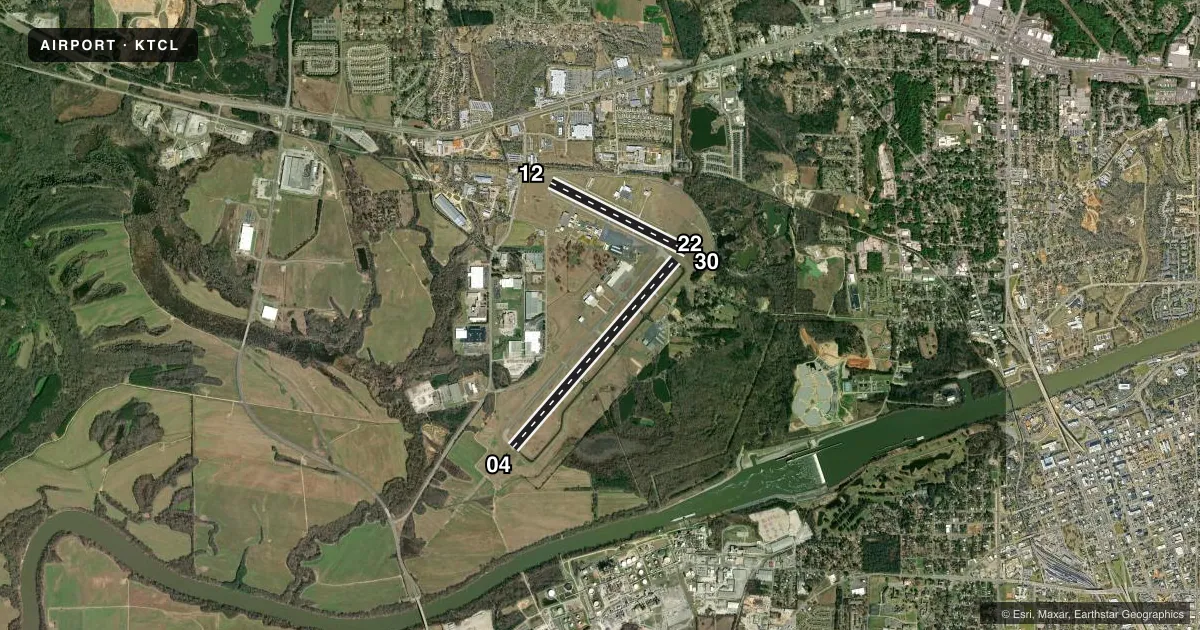
Runways & pattern
Full pagePattern entry · RWY 04
LEFT TRAFFIC| Runway | Heading (°M) | Length | Surface | Traffic |
|---|---|---|---|---|
| 04/22 | 41° / 221° | 6,498 ft | ASPH | Standard L |
| 12/30 | 117° / 297° | 4,000 ft | ASPH | Standard L |
Runway end performance
| End | TORA | TODA | ASDA | LDA | VGSI | Approach lights | Obstruction |
|---|---|---|---|---|---|---|---|
| 04 | — | — | — | — | — | MALSR | — |
| 22 | — | — | — | — | PAPI 4-box left(3°) | — | 38', tree, 1550' from thr, 100' R of cntrln, slope 35 |
| 12 | — | — | — | — | — | — | 40', tree, 850' from thr, 200' R of cntrln, slope 16 |
| 30 | — | — | — | — | PAPI 4-box right(3.5°) | — | 61', trees, 1725' from thr, 180' R of cntrln, slope 25 |
Declared distances in feet. TORA = takeoff run available, TODA = takeoff distance, ASDA = accelerate-stop, LDA = landing distance.
Airport sketch
Runways drawn to scale from FAA survey coordinates, rendered over satellite imagery. Not for navigation.
Approaches & charts
ILS · 1
Services on the field
Fuel grades, oxygen, maintenance, ramp storage and lighting — as declared to the FAA by the airport operator.
Fuel & services
- Fuel
- 100LLA
- Oxygen (bottled)
- Not available
- Oxygen (bulk)
- Low pressure
- Airframe repair
- Major
- Power plant repair
- Major
- Other services
- AFRT,AVNCS,CARGO,CHTR,INSTR,RNTL
Ramp & ground
- Transient storage
- Tie-down
- Hangar
- Landing fee
- Yes
- Customs
- Not available
- Lighting schedule
- SEE RMK
- Beacon schedule
- SS-SR
- Beacon
- White / Green (civil land)(WG)
- Wind indicator
- Lighted
- Segmented circle
- Yes
Fuel & FBOs
Cheapest 100LL and Jet A on the field and nearby. Always confirm with the FBO before taxi.
Airport notes
Surface conditions, obstructions, local procedures, lighting outages and other notes published with each FAA cycle.
General notes
- BIRDS & DEER ON & INVOF ARPT.
- FOR CD WHEN TWR CLSD, CTC BIRMINGHAM APCH AT 205-769-3890.
Lighting notes
- WHEN ATCT CLSD ACTVT HIRL RY 04/22, MALSR RY 04, PAPI RY 22, MIRL RWY 12/30 & TWY LGTS - CTAF.
Runway surface & condition
- 04/22PCR VALUE: 1059/F/D/X/T
- 12/30PCR VALUE: 50/F/C/X/T
- 12/30RWY 12/30 NOT AVBL FOR PART 121/PART 380 OPS WITH SKED PAX CARRYING OPS MORE THAN 9 PAX SEATS AND NON-SKED PAX CARRYING OPS MORE THAN 30 PAX SEATS. LGTD AS A VISUAL RWY.
Other notes
- 24 HR PPR RQR FOR UNSKED ACR OPNS GTR THAN 30 PAX SEATS 2130-0500 - CTC AMGR. INDEX B ARFF CAPABILITY AVBL H24.
VFR map & nearby airports
VFR sectional. Tap any ICAO chip to open that airport.
Key facts · KTCL
Answer card- ICAO
- KTCL
- Name
- TUSCALOOSA NTL
- Location
- TUSCALOOSA, ALABAMA
- Elevation
- 169.9 ft MSL
- Traffic pattern altitude
- 1,169.9 ft MSL (1,000 AGL)
- Control tower
- Towered · 0700-2000
- Total runways
- 2
- Longest runway
- 04/22 · 6,498 ft
- Published ILS approaches
- 1
- Published frequencies
- 9
- Magnetic variation
- 0°
- Current flight rules
- VFR
- Current wind
- 000° at 0 kt
- Favored runway now
- –
Tuscaloosa NTL sits in Tuscaloosa, Alabama at 169.9 ft MSL. It has two asphalt runways. The longest is 04/22 at 6,498 ft. Runway 12/30 is 4,000 ft. The field has a control tower. Tower hours are 0700 to 2000. When the tower is closed, use the published CTAF and follow the lighting instructions in the Chart Supplement. The airport has one ILS approach. It is for runway 04.
Pattern altitude is not published. Use the standard 1,000 ft AGL for light piston traffic unless ATC or the current Chart Supplement says otherwise. That puts the working pattern at about 1,170 ft MSL based on the field elevation. The airport has two on-field FBOs. Dixie Air Services carries 100LL and Jet A Prist. Ascension FBO carries 100LL, Jet A and Jet A Prist.
This is a controlled field with active traffic and published bird and deer activity in the area. Runway 12/30 is lighted as a visual runway. It also has operating limits for some airline and charter operations, so large aircraft should verify the current Chart Supplement before planning in. For clearance delivery when the tower is closed, contact Birmingham Approach. If you are new to KTCL, expect a busy towered environment with a long primary runway and a shorter crosswind option.