METAR & TAF KSTC
Current METAR
Observed 23:53Z
KSTC 272353Z 03010KT 10SM CLR 31/22 A2975 RMK AO2 SLP074 T03060222 10361 20306 51006
- Wind
- 030° @ 10 kt
- Visibility
- 10 SM
- Temp / Dew
- 31°C / 22°C
- Altimeter
- 29.75 inHg
- Clouds
- CLR
- Density alt
- 3,409 ft
- Ceiling
- Unlimited
- Rules
- VFR
Airport info & contacts
Manager on record, flight service, ARTCC, attendance schedule and pattern altitude — published by the FAA and refreshed every 28 days.
Location
- From city
- 4 NM E
- VFR sectional
- TWIN CITIES
- ARTCC
- ZMP · MINNEAPOLIS
- NOTAM facility
- STC (NOTAM-D)
Airport manager
- Name
- BILL P TOWLE
- Phone
- 320-255-7292
- Address
- 1550 45TH AVE SE STE 1, SAINT CLOUD MN 56304-9634
Flight service · Hours
- FSS PNM
- PRINCETON1-800-WX-BRIEF
- Attendance
- 0500-2330
Frequencies
Tap any row to copy the frequency to your clipboard.
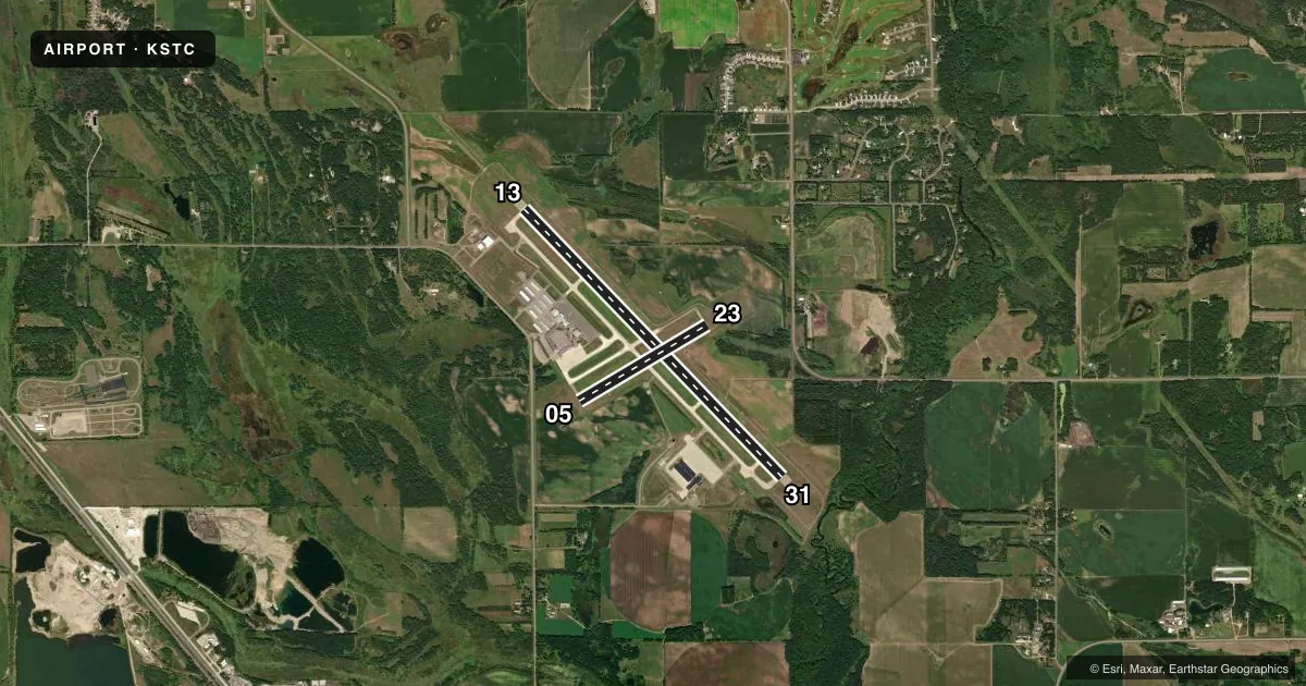
Runways & pattern
Full pagePattern entry · RWY 05
LEFT TRAFFIC| Runway | Heading (°M) | Length | Surface | Traffic |
|---|---|---|---|---|
| 13/31 | 133° / 313° | 7,500 ft | CONC | Standard L |
| 05/23Favored | 56° / 236° | 3,000 ft | ASPH | Standard L |
Runway end performance
| End | TORA | TODA | ASDA | LDA | VGSI | Approach lights | Obstruction |
|---|---|---|---|---|---|---|---|
| 13 | 7,500' | 7,500' | 7,000' | 7,000' | PAPI 4-box right(3°) | MALSR | — |
| 31 | 7,500' | 7,500' | 7,500' | 7,000' | PAPI 4-box left(3°) | MALSR | — |
| 05 | 3,000' | 3,000' | 3,000' | 3,000' | PAPI 4-box right(3°) | — | — |
| 23 | 3,000' | 3,000' | 3,000' | 3,000' | PAPI 4-box left(3°) | — | — |
Declared distances in feet. TORA = takeoff run available, TODA = takeoff distance, ASDA = accelerate-stop, LDA = landing distance.
Airport sketch
Runways drawn to scale from FAA survey coordinates, rendered over satellite imagery. Not for navigation.
Approaches & charts
ILS · 2
Services on the field
Fuel grades, oxygen, maintenance, ramp storage and lighting — as declared to the FAA by the airport operator.
Fuel & services
- Fuel
- 100LLA
- Oxygen (bottled)
- Not available
- Oxygen (bulk)
- High pressure
- Airframe repair
- Major
- Power plant repair
- Major
- Other services
- AVNCS,INSTR,RNTL,SALES
Ramp & ground
- Transient storage
- Tie-down
- Hangar
- Landing fee
- No fee published
- Customs
- Not available
- Lighting schedule
- SEE RMK
- Beacon schedule
- SS-SR
- Beacon
- White / Green (civil land)(WG)
- Wind indicator
- Lighted
- Segmented circle
- Yes
Fuel & FBOs
Cheapest 100LL and Jet A on the field and nearby. Always confirm with the FBO before taxi.
Airport notes
Surface conditions, obstructions, local procedures, lighting outages and other notes published with each FAA cycle.
General notes
- RY 31 CALM WIND RY.
- DEER, MIGRATORY WATERFOWL, AND OTHER WILDLIFE ON & INVOF ARPT.
- FLIGHT TRAINING ON & INVOF ARPT.
- CROP DUSTING OPERATIONS ON AND IN VICINITY OF AIRPORT DURING SUMMER MONTHS.
- HELIPAD NOT VISIBLE FROM ATCT AND APPROACH SURFACES.
- LINE OF SIGHT VISIBILITY IS RESTRICTED FROM THE 13 & 23 APPROACH AND RUNWAY 13 & 5 APPROACH
- FOR CD WHEN ATCT IS CLSD CTC FSS VIA RCO, IF UNA CTC MINNEAPOLIS ARTCC AT 651-463-5588.
Lighting notes
- ACTVT MALSR RWY 13 & 31 - CTAF. PAPI 13 & 31; HIRL RWY 13/31; MIRL RWY 05/23 PRESET ON LOW INTST, TO INCR INTST & ACTVT - CTAF.
Runway surface & condition
- 05/23PCR VALUE: 28/F/A/X/T
- 13/31PCR VALUE: 380/R/A/W/T
- 05/23RWY 05/23 NOT AVBL FOR PART 121/PART 380 OPS WITH SKED PAX CARRYING OPS MORE THAN 9 PAX SEATS AND NON-SKED PAX CARRYING OPS MORE THAN 30 PAX SEATS.
- 13/31RWY 13/31 200 FT BLAST PAD EACH END.
Other notes
- 24 HRS PPR FOR UNSKED ACR OPNS WITH MORE THAN 30 PSGR SEATS CALL AMGR 320-255-7292.
- MANAGERWILLIAM.TOWLE@CI.STCLOUD.MN.US.
VFR map & nearby airports
VFR sectional. Tap any ICAO chip to open that airport.
Key facts · KSTC
Answer card- ICAO
- KSTC
- Name
- ST CLOUD SKY CENTRAL
- Location
- ST CLOUD, MINNESOTA
- Elevation
- 1,030.5 ft MSL
- Traffic pattern altitude
- 2,030.5 ft MSL (1,000 AGL)
- Control tower
- Towered · 0700-2300
- Total runways
- 2
- Longest runway
- 13/31 · 7,500 ft
- Published ILS approaches
- 2
- Published frequencies
- 4
- Magnetic variation
- 3°
- Current flight rules
- VFR
- Current wind
- 030° at 10 kt
- Favored runway now
- RWY 05
ST CLOUD SKY CENTRAL sits in St. Cloud, Minnesota. The field elevation is 1,030.5 ft MSL. It has two runways. The longest is 13/31 at 7,500 ft. Runway 05/23 is 3,000 ft. The tower is open 0700 to 2300. When the tower is closed, use the published clearance delivery backup through Flight Service or Minneapolis ARTCC if needed.
ILS approaches are available to Runways 13 and 31. The pattern altitude is not published, so use the standard 1,000 ft AGL for light piston traffic unless ATC or the Chart Supplement says otherwise. St. Cloud Aviation is on the field. It carries 100LL and Jet A. Call ahead at (320) 253-0480 if you need current ramp or fuel details.
A few operational items matter here. Runway 05/23 is not available for certain larger passenger operations. Line of sight is restricted on the 13 and 23 approach sides plus the 13 and 5 approach sides. Runway 31 is the calm wind runway. MALSR, PAPI and high intensity lighting are on 13/31. Runway 05/23 uses medium intensity lights that start low and are raised from the CTAF. Wildlife is a real factor here. Deer and migratory waterfowl are reported on and near the airport. Crop dusting also occurs in summer. Check the current FAA Chart Supplement for any current noise or operational notes before you go.